Tavas elevation
Tavas (Denizli), Turkey elevation is 948 meters and Tavas elevation in feet is 3110 ft above sea level [src 1]. Tavas is a seat of a second-order administrative division (feature code) with elevation that is 225 meters (738 ft) bigger than average city elevation in Turkey.
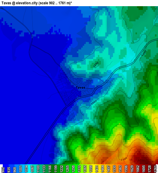
Below is the Elevation map of Tavas, which displays elevation range with different colors. Scale of the first map is from 902 to 1761 m (2959 to 5778 ft) with average elevation of 1057.3 meters (=3469 ft) [note 1]
These maps also provides idea of topography and contour of this city, they are displayed at different zoom levels. More info about maps, scale and edge coordinates you can find below images.
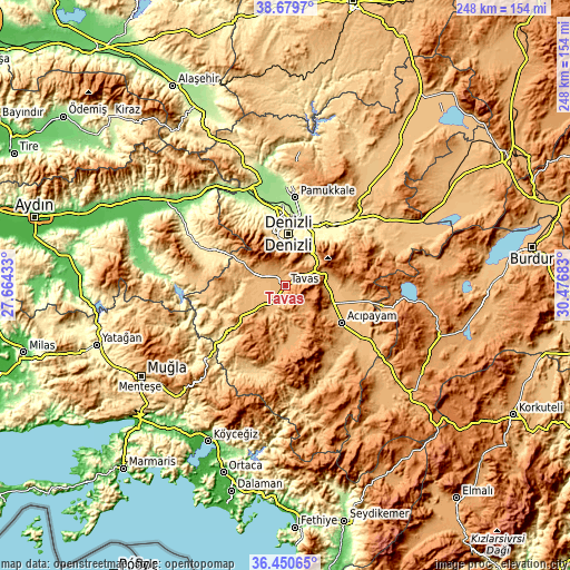
| \ | Map #1 | Map #2 | Topo.Map |
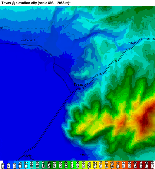
| Scale [m] | 902..1761 m | 893..2086 m | × |
| Scale [ft] | 2959..5778 ft | 2930..6844 ft | × |
| Average | 1057.3 m = 3469 ft | 1102.5 m = 3617 ft | × |
| Width | 7.75 km = 4.8 mi | 15.49 km = 9.6 mi | 247.8 km = 154 mi |
| Height | 7.75 km = 4.8 mi | 15.49 km = 9.6 mi | 247.8 km = 154 mi |
| ↑Max Latitude | 37.608332° | 37.643137° | 38.6797° |
| Latitude at center | 37.57351° | 37.57351° | 37.57351° |
| ↓Min Latitude | 37.538672° | 37.503818° | 36.45065° |
| ← Min Longitude | 29.026635° | 28.982689° | 27.66433° |
| Longitude center | 29.07058° | 29.07058° | 29.07058° |
| →Max Longitude | 29.114525° | 29.158471° | 30.47683° |
Nearby cities:
Cities around Tavas sort by population:
• Denizli elevation 405 m
22.4 km,  3°
3°
• Merkezefendi 439 m
25.9 km,  354°
354°
• Serinhisar 958 m
17.3 km,  87°
87°
• Acıpayam 947 m
29.7 km,  124°
124°
• Pamukkale 255 m
38.4 km,  6°
6°
• Honaz 559 m
26.9 km,  40°
40°
• Kale 1059 m
24.9 km,  233°
233°
• Nikfer 1064 m
19.6 km,  162°
162°
• Babadağ 750 m
32.1 km,  324°
324°
• Beyağaç 697 m
40.6 km,  202°
202°
• Pamukkale 329 m
24.4 km, 6°
• Kızılcabölük 962 m
6.3 km,  312°
312°
Multilingual:
 En español:
Tavas elevación 948 m.
 En France:
Tavas élévation 948 m.


Sources and notes:
- [note 1] Map square and city borders are not equal. Map elevation data is calculated only from area inside that square.
- [src 1] Elevation data from geonames database provided with same terms of usage.
- [src 2] The elevation map of Tavas is generated using elevation data from NASA's 3 arcsec (90m) resolution SRTM data.
- [src 3] Base (background) map © OpenStreetMap contributors tiles are generated by Geofabrik and OpenTopoMap.
Copyright & License:
This Tavas Elevation Map is licensed under CC BY-SA. You may reuse any part from this page, if you give a proper credit by linking to this URL:
 More info on terms of use page.