Nong Phai elevation
Nong Phai (Phetchabun), Thailand elevation is 111 meters and Nong Phai elevation in feet is 364 ft above sea level [src 1]. Nong Phai is a seat of a second-order administrative division (feature code) with elevation that is 14 meters (46 ft) smaller than average city elevation in Thailand.
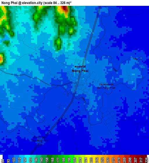
Below is the Elevation map of Nong Phai, which displays elevation range with different colors. Scale of the first map is from 84 to 326 m (276 to 1070 ft) with average elevation of 107 meters (=351 ft) [note 1]
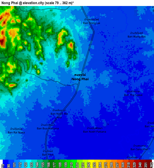
These maps also provides idea of topography and contour of this city, they are displayed at different zoom levels. More info about maps, scale and edge coordinates you can find below images.

| \ | Map #1 | Map #2 | Topo.Map |
| Scale [m] | 84..326 m | 79..362 m | × |
| Scale [ft] | 276..1070 ft | 259..1188 ft | × |
| Average | 107 m = 351 ft | 113.3 m = 372 ft | × |
| Width | 9.39 km = 5.8 mi | 18.79 km = 11.7 mi | 300.6 km = 186.8 mi |
| Height | 9.39 km = 5.8 mi | 18.79 km = 11.7 mi | 300.6 km = 186.8 mi |
| ↑Max Latitude | 16.032491° | 16.074722° | 17.33741° |
| Latitude at center | 15.99025° | 15.99025° | 15.99025° |
| ↓Min Latitude | 15.948001° | 15.905742° | 14.63396° |
| ← Min Longitude | 101.017885° | 100.973939° | 99.65558° |
| Longitude center | 101.06183° | 101.06183° | 101.06183° |
| →Max Longitude | 101.105775° | 101.149721° | 102.46808° |
Nearby cities:
Cities around Nong Phai sort by population:
• Phetchabun elevation 120 m
48.8 km,  12°
12°
• Wichian Buri 72 m
37.3 km,  172°
172°
• Chon Daen 106 m
30.9 km,  315°
315°
• Thap Khlo 51 m
53.2 km,  290°
290°
• Nong Bua 43 m
52.8 km,  254°
254°
• Phai Sali 55 m
61.9 km,  225°
225°
• Sap Yai 344 m
71.2 km,  123°
123°
• Si Thep 64 m
59.8 km,  179°
179°
• Wang Pong 128 m
48.5 km, 323°
• Dong Charoen 60 m
42.8 km,  274°
274°
• Phakdi Chumphon 275 m
39.7 km,  103°
103°
• Bueng Sam Phan 190 m
23.4 km,  220°
220°
Multilingual:
 En español:
Nong Phai elevación 111 m.
 En France:
Nong Phai élévation 111 m.
 Auf Deutsch:
Nong Phai höhe über dem Meeresspiegel ist 111 m.

Sources and notes:
- [note 1] Map square and city borders are not equal. Map elevation data is calculated only from area inside that square.
- [src 1] Elevation data from geonames database provided with same terms of usage.
- [src 2] The elevation map of Nong Phai is generated using elevation data from NASA's 3 arcsec (90m) resolution SRTM data.
- [src 3] Base (background) map © OpenStreetMap contributors tiles are generated by Geofabrik and OpenTopoMap.
Copyright & License:
This Nong Phai Elevation Map is licensed under CC BY-SA. You may reuse any part from this page, if you give a proper credit by linking to this URL:
 More info on terms of use page.