Si Thep elevation
Si Thep (Phetchabun), Thailand elevation is 64 meters and Si Thep elevation in feet is 210 ft above sea level [src 1]. Si Thep is a seat of a second-order administrative division (feature code) with elevation that is 61 meters (200 ft) smaller than average city elevation in Thailand.
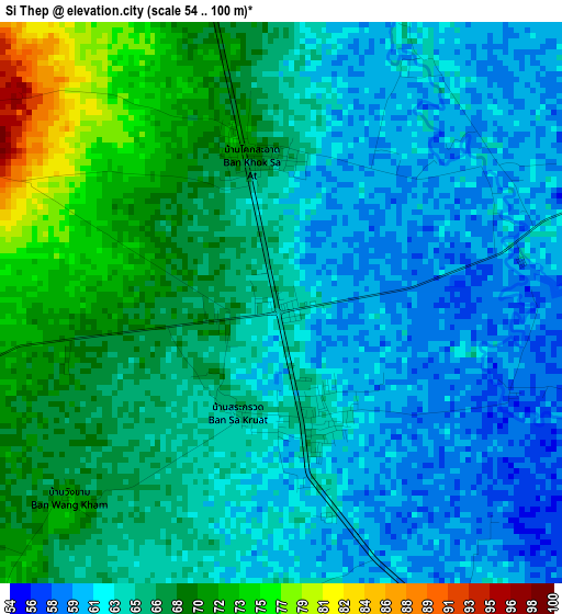
Below is the Elevation map of Si Thep, which displays elevation range with different colors. Scale of the first map is from 54 to 100 m (177 to 328 ft) with average elevation of 65.1 meters (=214 ft) [note 1]
These maps also provides idea of topography and contour of this city, they are displayed at different zoom levels. More info about maps, scale and edge coordinates you can find below images.
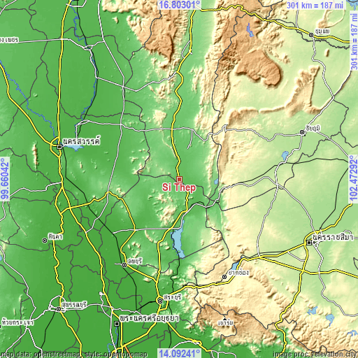
| \ | Map #1 | Topo.Map |
| Scale [m] | 54..100 m | × |
| Scale [ft] | 177..328 ft | × |
| Average | 65.1 m = 214 ft | × |
| Width | 9.42 km = 5.9 mi | 301.4 km = 187.3 mi |
| Height | 9.42 km = 5.9 mi | 301.4 km = 187.3 mi |
| ↑Max Latitude | 15.494493° | 16.80301° |
| Latitude at center | 15.45214° | 15.45214° |
| ↓Min Latitude | 15.409779° | 14.09241° |
| ← Min Longitude | 101.022725° | 99.66042° |
| Longitude center | 101.06667° | 101.06667° |
| →Max Longitude | 101.110615° | 102.47292° |
Nearby cities:
Cities around Si Thep sort by population:
• Wichian Buri elevation 72 m
23.3 km,  10°
10°
• Chai Badan 44 m
28.9 km,  165°
165°
• Phai Sali 55 m
47.6 km,  290°
290°
• Khok Samrong 36 m
56.6 km,  220°
220°
• Thepharak 282 m
54.3 km,  107°
107°
• Nong Muang 119 m
49.7 km,  242°
242°
• Bueng Sam Phan 190 m
44.9 km,  339°
339°
• Tha Luang 58 m
42.5 km,  175°
175°
• Thep Sathit 317 m
41.7 km,  99°
99°
• Sa Bot 48 m
36.9 km, 223°
• Lam Sonthi 85 m
36 km,  117°
117°
• Khok Charoen 77 m
27.8 km,  253°
253°
Multilingual:
 En español:
Si Thep elevación 64 m.
 En France:
Si Thep élévation 64 m.


Sources and notes:
- [note 1] Map square and city borders are not equal. Map elevation data is calculated only from area inside that square.
- [src 1] Elevation data from geonames database provided with same terms of usage.
- [src 2] The elevation map of Si Thep is generated using elevation data from NASA's 3 arcsec (90m) resolution SRTM data.
- [src 3] Base (background) map © OpenStreetMap contributors tiles are generated by Geofabrik and OpenTopoMap.
Copyright & License:
This Si Thep Elevation Map is licensed under CC BY-SA. You may reuse any part from this page, if you give a proper credit by linking to this URL:
 More info on terms of use page.