Wichian Buri elevation
Wichian Buri (Phetchabun), Thailand elevation is 72 meters and Wichian Buri elevation in feet is 236 ft above sea level [src 1]. Wichian Buri is a seat of a second-order administrative division (feature code) with elevation that is 53 meters (174 ft) smaller than average city elevation in Thailand.
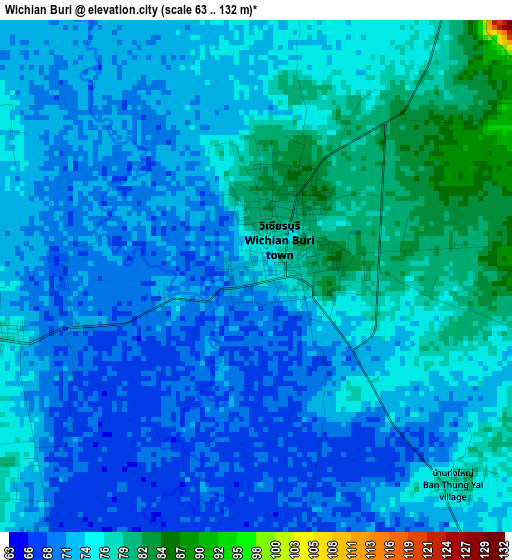
Below is the Elevation map of Wichian Buri, which displays elevation range with different colors. Scale of the first map is from 63 to 132 m (207 to 433 ft) with average elevation of 73.5 meters (=241 ft) [note 1]
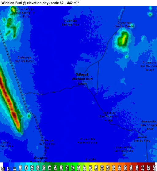
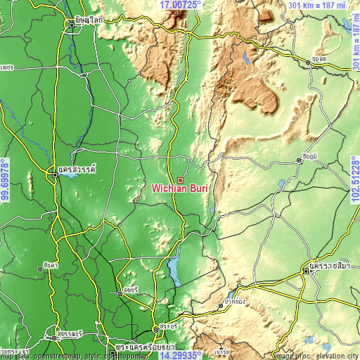
These maps also provides idea of topography and contour of this city, they are displayed at different zoom levels. More info about maps, scale and edge coordinates you can find below images.
| \ | Map #1 | Map #2 | Topo.Map |
| Scale [m] | 63..132 m | 62..442 m | × |
| Scale [ft] | 207..433 ft | 203..1450 ft | × |
| Average | 73.5 m = 241 ft | 85.5 m = 281 ft | × |
| Width | 9.41 km = 5.8 mi | 18.82 km = 11.7 mi | 301.1 km = 187.1 mi |
| Height | 9.41 km = 5.8 mi | 18.82 km = 11.7 mi | 301.1 km = 187.1 mi |
| ↑Max Latitude | 15.70009° | 15.742392° | 17.00725° |
| Latitude at center | 15.65778° | 15.65778° | 15.65778° |
| ↓Min Latitude | 15.615461° | 15.573133° | 14.29935° |
| ← Min Longitude | 101.062085° | 101.018139° | 99.69978° |
| Longitude center | 101.10603° | 101.10603° | 101.10603° |
| →Max Longitude | 101.149975° | 101.193921° | 102.51228° |
Nearby cities:
Cities around Wichian Buri sort by population:
• Nong Phai elevation 111 m
37.3 km,  352°
352°
• Chai Badan 44 m
51 km,  176°
176°
• Nong Bua 43 m
60.2 km,  292°
292°
• Phai Sali 55 m
49.3 km,  262°
262°
• Sa Bot 48 m
57.9 km,  210°
210°
• Sap Yai 344 m
54.7 km,  92°
92°
• Lam Sonthi 85 m
48.3 km,  145°
145°
• Thep Sathit 317 m
47.3 km,  128°
128°
• Khok Charoen 77 m
43.7 km,  224°
224°
• Phakdi Chumphon 275 m
43.6 km,  50°
50°
• Bueng Sam Phan 190 m
27.7 km,  313°
313°
• Si Thep 64 m
23.3 km,  190°
190°
Multilingual:
 En español:
Wichian Buri elevación 72 m.
 En France:
Wichian Buri élévation 72 m.
 Auf Deutsch:
Wichian Buri höhe über dem Meeresspiegel ist 72 m.

Sources and notes:
- [note 1] Map square and city borders are not equal. Map elevation data is calculated only from area inside that square.
- [src 1] Elevation data from geonames database provided with same terms of usage.
- [src 2] The elevation map of Wichian Buri is generated using elevation data from NASA's 3 arcsec (90m) resolution SRTM data.
- [src 3] Base (background) map © OpenStreetMap contributors tiles are generated by Geofabrik and OpenTopoMap.
Copyright & License:
This Wichian Buri Elevation Map is licensed under CC BY-SA. You may reuse any part from this page, if you give a proper credit by linking to this URL:
 More info on terms of use page.