Chai Badan elevation
Chai Badan (Lop Buri), Thailand elevation is 44 meters and Chai Badan elevation in feet is 144 ft above sea level [src 1]. Chai Badan is a populated place (feature code) with elevation that is 81 meters (266 ft) smaller than average city elevation in Thailand.
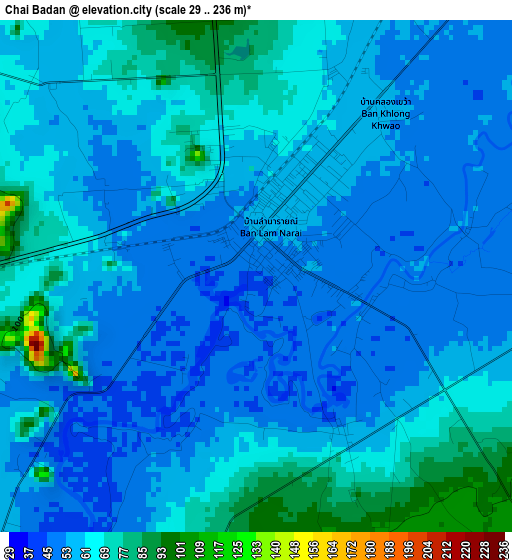
Below is the Elevation map of Chai Badan, which displays elevation range with different colors. Scale of the first map is from 29 to 236 m (95 to 774 ft) with average elevation of 59.2 meters (=194 ft) [note 1]
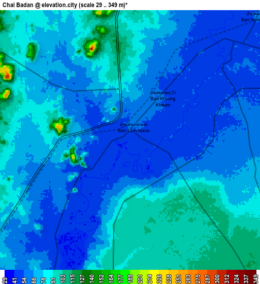
These maps also provides idea of topography and contour of this city, they are displayed at different zoom levels. More info about maps, scale and edge coordinates you can find below images.
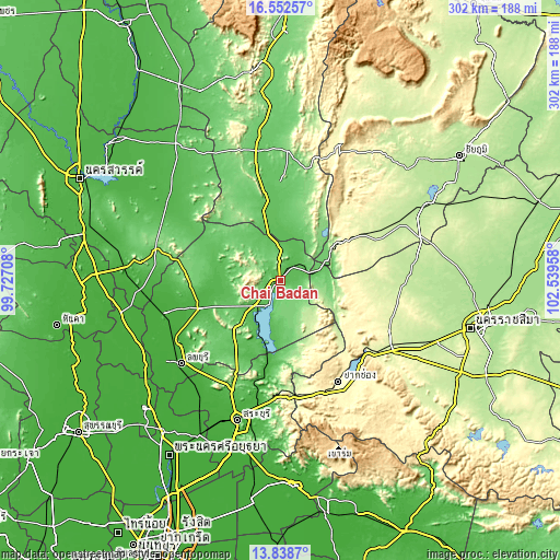
| \ | Map #1 | Map #2 | Topo.Map |
| Scale [m] | 29..236 m | 29..349 m | × |
| Scale [ft] | 95..774 ft | 95..1145 ft | × |
| Average | 59.2 m = 194 ft | 72 m = 236 ft | × |
| Width | 9.43 km = 5.9 mi | 18.86 km = 11.7 mi | 301.8 km = 187.5 mi |
| Height | 9.43 km = 5.9 mi | 18.86 km = 11.7 mi | 301.8 km = 187.5 mi |
| ↑Max Latitude | 15.242404° | 15.284799° | 16.55257° |
| Latitude at center | 15.2° | 15.2° | 15.2° |
| ↓Min Latitude | 15.157588° | 15.115167° | 13.8387° |
| ← Min Longitude | 101.089385° | 101.045439° | 99.72708° |
| Longitude center | 101.13333° | 101.13333° | 101.13333° |
| →Max Longitude | 101.177275° | 101.221221° | 102.53958° |
Nearby cities:
Cities around Chai Badan sort by population:
• Wichian Buri elevation 72 m
51 km,  356°
356°
• Nong Muang 119 m
51.5 km,  275°
275°
• Khok Samrong 36 m
46.5 km,  251°
251°
• Thepharak 282 m
46.3 km,  74°
74°
• Phatthana Nikhom 46 m
41.4 km,  202°
202°
• Thep Sathit 317 m
40.2 km,  57°
57°
• Wang Muang 70 m
39.8 km,  181°
181°
• Khok Charoen 77 m
39.2 km,  300°
300°
• Sa Bot 48 m
32.5 km,  271°
271°
• Si Thep 64 m
28.9 km,  345°
345°
• Lam Sonthi 85 m
27.2 km, 65°
• Tha Luang 58 m
14.8 km,  194°
194°
Multilingual:
 En español:
Chai Badan elevación 44 m.
 En France:
Chai Badan élévation 44 m.
 Auf Deutsch:
Chai Badan höhe über dem Meeresspiegel ist 44 m.

Sources and notes:
- [note 1] Map square and city borders are not equal. Map elevation data is calculated only from area inside that square.
- [src 1] Elevation data from geonames database provided with same terms of usage.
- [src 2] The elevation map of Chai Badan is generated using elevation data from NASA's 3 arcsec (90m) resolution SRTM data.
- [src 3] Base (background) map © OpenStreetMap contributors tiles are generated by Geofabrik and OpenTopoMap.
Copyright & License:
This Chai Badan Elevation Map is licensed under CC BY-SA. You may reuse any part from this page, if you give a proper credit by linking to this URL:
 More info on terms of use page.