Phetchabun elevation
Phetchabun, Thailand elevation is 120 meters and Phetchabun elevation in feet is 394 ft above sea level [src 1]. Phetchabun is a seat of a first-order administrative division (feature code) with elevation that is 5 meters (16 ft) smaller than average city elevation in Thailand.
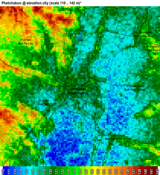
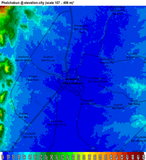
Below is the Elevation map of Phetchabun, which displays elevation range with different colors. Scale of the first map is from 110 to 142 m (361 to 466 ft) with average elevation of 120.7 meters (=396 ft) [note 1]
These maps also provides idea of topography and contour of this city, they are displayed at different zoom levels. More info about maps, scale and edge coordinates you can find below images.
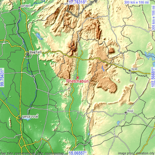
| \ | Map #1 | Map #2 | Topo.Map |
| Scale [m] | 110..142 m | 107..496 m | × |
| Scale [ft] | 361..466 ft | 351..1627 ft | × |
| Average | 120.7 m = 396 ft | 137.5 m = 451 ft | × |
| Width | 9.37 km = 5.8 mi | 18.75 km = 11.7 mi | 299.9 km = 186.3 mi |
| Height | 9.37 km = 5.8 mi | 18.75 km = 11.7 mi | 300 km = 186.4 mi |
| ↑Max Latitude | 16.461189° | 16.503328° | 17.76315° |
| Latitude at center | 16.41904° | 16.41904° | 16.41904° |
| ↓Min Latitude | 16.376882° | 16.334715° | 15.06557° |
| ← Min Longitude | 101.116615° | 101.072669° | 99.75431° |
| Longitude center | 101.16056° | 101.16056° | 101.16056° |
| →Max Longitude | 101.204505° | 101.248451° | 102.56681° |
Nearby cities:
Cities around Phetchabun sort by population:
• Nong Phai elevation 111 m
48.8 km,  192°
192°
• Chon Daen 106 m
41 km,  231°
231°
• Lom Sak 147 m
41 km,  12°
12°
• Thap Khlo 51 m
66.7 km,  244°
244°
• Wang Sai Phun 50 m
66.5 km,  267°
267°
• Dong Charoen 60 m
69.2 km, 230°
• Nam Nao 855 m
66.6 km,  54°
54°
• Phakdi Chumphon 275 m
63.6 km,  153°
153°
• Noen Maprang 60 m
58.6 km,  286°
286°
• Lom Kao 163 m
52.4 km, 7°
• Wang Pong 128 m
40.1 km,  257°
257°
• Khao Kho 926 m
30.4 km,  330°
330°
Multilingual:
 En español:
Phetchabun elevación 120 m.
 En France:
Phetchabun élévation 120 m.
 Auf Deutsch:
Phetchabun höhe über dem Meeresspiegel ist 120 m.

Sources and notes:
- [note 1] Map square and city borders are not equal. Map elevation data is calculated only from area inside that square.
- [src 1] Elevation data from geonames database provided with same terms of usage.
- [src 2] The elevation map of Phetchabun is generated using elevation data from NASA's 3 arcsec (90m) resolution SRTM data.
- [src 3] Base (background) map © OpenStreetMap contributors tiles are generated by Geofabrik and OpenTopoMap.
Copyright & License:
This Phetchabun Elevation Map is licensed under CC BY-SA. You may reuse any part from this page, if you give a proper credit by linking to this URL:
 More info on terms of use page.