Lom Sak elevation
Lom Sak (Phetchabun), Thailand elevation is 147 meters and Lom Sak elevation in feet is 482 ft above sea level [src 1]. Lom Sak is a seat of a second-order administrative division (feature code) with elevation that is 22 meters (72 ft) bigger than average city elevation in Thailand.
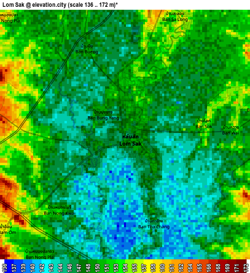
Below is the Elevation map of Lom Sak, which displays elevation range with different colors. Scale of the first map is from 136 to 172 m (446 to 564 ft) with average elevation of 148.5 meters (=487 ft) [note 1]
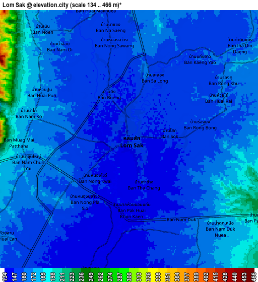
These maps also provides idea of topography and contour of this city, they are displayed at different zoom levels. More info about maps, scale and edge coordinates you can find below images.
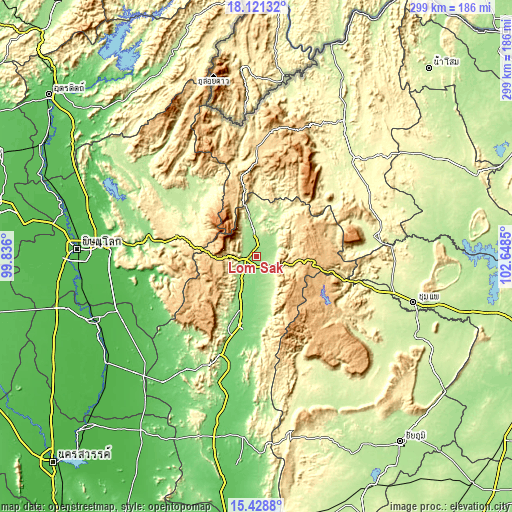
| \ | Map #1 | Map #2 | Topo.Map |
| Scale [m] | 136..172 m | 134..466 m | × |
| Scale [ft] | 446..564 ft | 440..1529 ft | × |
| Average | 148.5 m = 487 ft | 162.8 m = 534 ft | × |
| Width | 9.36 km = 5.8 mi | 18.71 km = 11.6 mi | 299.4 km = 186 mi |
| Height | 9.36 km = 5.8 mi | 18.71 km = 11.6 mi | 299.4 km = 186 mi |
| ↑Max Latitude | 16.8219° | 16.86396° | 18.12132° |
| Latitude at center | 16.77983° | 16.77983° | 16.77983° |
| ↓Min Latitude | 16.737751° | 16.695663° | 15.4288° |
| ← Min Longitude | 101.198305° | 101.154359° | 99.836° |
| Longitude center | 101.24225° | 101.24225° | 101.24225° |
| →Max Longitude | 101.286195° | 101.330141° | 102.6485° |
Nearby cities:
Cities around Lom Sak sort by population:
• Phetchabun elevation 120 m
41 km,  192°
192°
• Phu Kradueng 268 m
69.3 km,  80°
80°
• Nakhon Thai 211 m
55.9 km,  309°
309°
• Khon San 250 m
74.5 km,  104°
104°
• Phu Pha Man 249 m
71.6 km, 101°
• Noen Maprang 60 m
69.1 km,  249°
249°
• Wang Pong 128 m
68.3 km,  224°
224°
• Phu Luang 277 m
60.1 km,  48°
48°
• Dan Sai 357 m
56.5 km,  349°
349°
• Nam Nao 855 m
45.5 km,  91°
91°
• Khao Kho 926 m
27.1 km,  239°
239°
• Lom Kao 163 m
11.9 km, 353°
Multilingual:
 En español:
Lom Sak elevación 147 m.
 En France:
Lom Sak élévation 147 m.


Sources and notes:
- [note 1] Map square and city borders are not equal. Map elevation data is calculated only from area inside that square.
- [src 1] Elevation data from geonames database provided with same terms of usage.
- [src 2] The elevation map of Lom Sak is generated using elevation data from NASA's 3 arcsec (90m) resolution SRTM data.
- [src 3] Base (background) map © OpenStreetMap contributors tiles are generated by Geofabrik and OpenTopoMap.
Copyright & License:
This Lom Sak Elevation Map is licensed under CC BY-SA. You may reuse any part from this page, if you give a proper credit by linking to this URL:
 More info on terms of use page.