Lom Kao elevation
Lom Kao (Phetchabun), Thailand elevation is 163 meters and Lom Kao elevation in feet is 535 ft above sea level [src 1]. Lom Kao is a seat of a second-order administrative division (feature code) with elevation that is 38 meters (125 ft) bigger than average city elevation in Thailand.
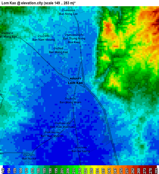
Below is the Elevation map of Lom Kao, which displays elevation range with different colors. Scale of the first map is from 149 to 283 m (489 to 928 ft) with average elevation of 175.9 meters (=577 ft) [note 1]
These maps also provides idea of topography and contour of this city, they are displayed at different zoom levels. More info about maps, scale and edge coordinates you can find below images.
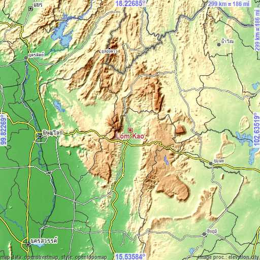
| \ | Map #1 | Topo.Map |
| Scale [m] | 149..283 m | × |
| Scale [ft] | 489..928 ft | × |
| Average | 175.9 m = 577 ft | × |
| Width | 9.35 km = 5.8 mi | 299.2 km = 185.9 mi |
| Height | 9.35 km = 5.8 mi | 299.2 km = 185.9 mi |
| ↑Max Latitude | 16.928186° | 18.22685° |
| Latitude at center | 16.88614° | 16.88614° |
| ↓Min Latitude | 16.844085° | 15.53584° |
| ← Min Longitude | 101.184995° | 99.82269° |
| Longitude center | 101.22894° | 101.22894° |
| →Max Longitude | 101.272885° | 102.63519° |
Nearby cities:
Cities around Lom Kao sort by population:
• Phetchabun elevation 120 m
52.4 km,  187°
187°
• Lom Sak 147 m
11.9 km,  173°
173°
• Phu Kradueng 268 m
69.8 km,  90°
90°
• Nakhon Thai 211 m
48 km,  299°
299°
• Noen Maprang 60 m
72.7 km,  240°
240°
• Nong Hin 323 m
71.9 km,  68°
68°
• Na Haeo 494 m
68.8 km,  345°
345°
• Phu Ruea 632 m
64.7 km,  12°
12°
• Phu Luang 277 m
54.1 km,  58°
58°
• Nam Nao 855 m
48.7 km,  105°
105°
• Dan Sai 357 m
44.7 km, 348°
• Khao Kho 926 m
33.6 km,  220°
220°
Multilingual:
 En español:
Lom Kao elevación 163 m.
 En France:
Lom Kao élévation 163 m.


Sources and notes:
- [note 1] Map square and city borders are not equal. Map elevation data is calculated only from area inside that square.
- [src 1] Elevation data from geonames database provided with same terms of usage.
- [src 2] The elevation map of Lom Kao is generated using elevation data from NASA's 3 arcsec (90m) resolution SRTM data.
- [src 3] Base (background) map © OpenStreetMap contributors tiles are generated by Geofabrik and OpenTopoMap.
Copyright & License:
This Lom Kao Elevation Map is licensed under CC BY-SA. You may reuse any part from this page, if you give a proper credit by linking to this URL:
 More info on terms of use page.