Na Haeo elevation
Na Haeo (Loei), Thailand elevation is 494 meters and Na Haeo elevation in feet is 1621 ft above sea level [src 1]. Na Haeo is a seat of a second-order administrative division (feature code) with elevation that is 369 meters (1211 ft) bigger than average city elevation in Thailand.
Below is the Elevation map of Na Haeo, which displays elevation range with different colors. Scale of the first map is from 463 to 918 m (1519 to 3012 ft) with average elevation of 581.4 meters (=1907 ft) [note 1]
These maps also provides idea of topography and contour of this city, they are displayed at different zoom levels. More info about maps, scale and edge coordinates you can find below images.
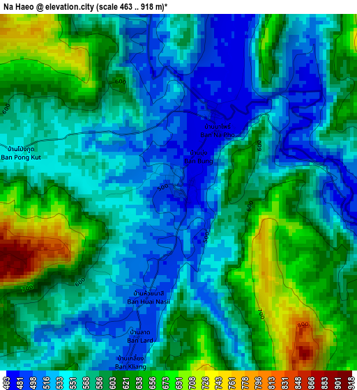
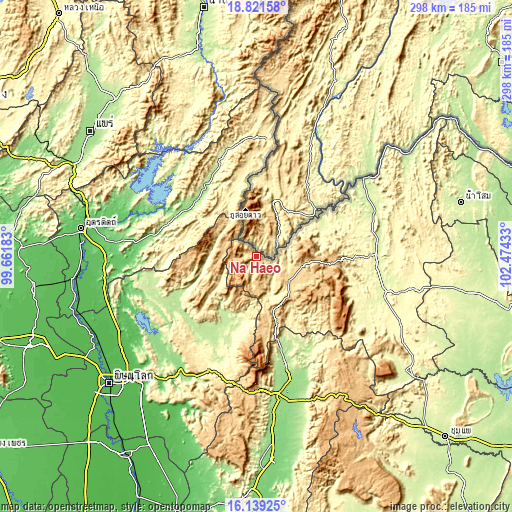
| \ | Map #1 | Topo.Map |
| Scale [m] | 463..918 m | × |
| Scale [ft] | 1519..3012 ft | × |
| Average | 581.4 m = 1907 ft | × |
| Width | 9.32 km = 5.8 mi | 298.2 km = 185.3 mi |
| Height | 9.32 km = 5.8 mi | 298.3 km = 185.4 mi |
| ↑Max Latitude | 17.52727° | 18.82158° |
| Latitude at center | 17.48536° | 17.48536° |
| ↓Min Latitude | 17.44344° | 16.13925° |
| ← Min Longitude | 101.024135° | 99.66183° |
| Longitude center | 101.06808° | 101.06808° |
| →Max Longitude | 101.112025° | 102.47433° |
Nearby cities:
Cities around Na Haeo sort by population:
• Loei elevation 244 m
69.9 km,  89°
89°
• Wang Saphung 254 m
77.1 km,  105°
105°
• Nakhon Thai 211 m
49.3 km,  209°
209°
• Chat Trakan 210 m
54.8 km,  244°
244°
• Phu Luang 277 m
74 km,  121°
121°
• Lom Kao 163 m
68.8 km,  165°
165°
• Fak Tha 227 m
60.5 km,  340°
340°
• Ban Khok 433 m
60.1 km,  359°
359°
• Nam Pat 155 m
48.8 km,  303°
303°
• Tha Li 268 m
40.4 km,  67°
67°
• Phu Ruea 632 m
31.4 km,  96°
96°
• Dan Sai 357 m
24.3 km,  159°
159°
Multilingual:
 En español:
Na Haeo elevación 494 m.
 En France:
Na Haeo élévation 494 m.


Sources and notes:
- [note 1] Map square and city borders are not equal. Map elevation data is calculated only from area inside that square.
- [src 1] Elevation data from geonames database provided with same terms of usage.
- [src 2] The elevation map of Na Haeo is generated using elevation data from NASA's 3 arcsec (90m) resolution SRTM data.
- [src 3] Base (background) map © OpenStreetMap contributors tiles are generated by Geofabrik and OpenTopoMap.
Copyright & License:
This Na Haeo Elevation Map is licensed under CC BY-SA. You may reuse any part from this page, if you give a proper credit by linking to this URL:
 More info on terms of use page.