Tha Li elevation
Tha Li (Loei), Thailand elevation is 268 meters and Tha Li elevation in feet is 879 ft above sea level [src 1]. Tha Li is a seat of a second-order administrative division (feature code) with elevation that is 143 meters (469 ft) bigger than average city elevation in Thailand.
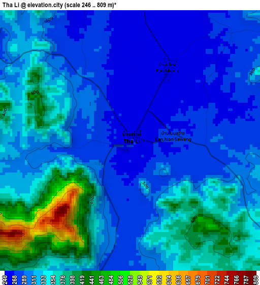
Below is the Elevation map of Tha Li, which displays elevation range with different colors. Scale of the first map is from 246 to 809 m (807 to 2654 ft) with average elevation of 323.7 meters (=1062 ft) [note 1]
These maps also provides idea of topography and contour of this city, they are displayed at different zoom levels. More info about maps, scale and edge coordinates you can find below images.
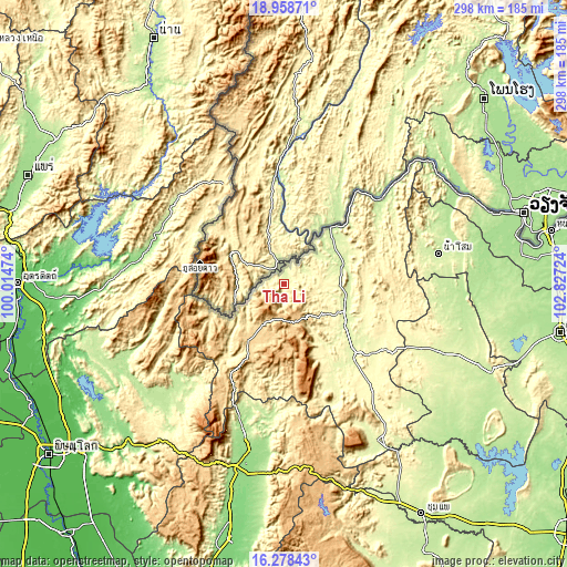
| \ | Map #1 | Topo.Map |
| Scale [m] | 246..809 m | × |
| Scale [ft] | 807..2654 ft | × |
| Average | 323.7 m = 1062 ft | × |
| Width | 9.31 km = 5.8 mi | 298 km = 185.2 mi |
| Height | 9.31 km = 5.8 mi | 298 km = 185.2 mi |
| ↑Max Latitude | 17.665428° | 18.95871° |
| Latitude at center | 17.62355° | 17.62355° |
| ↓Min Latitude | 17.581662° | 16.27843° |
| ← Min Longitude | 101.377045° | 100.01474° |
| Longitude center | 101.42099° | 101.42099° |
| →Max Longitude | 101.464935° | 102.82724° |
Nearby cities:
Cities around Tha Li sort by population:
• Loei elevation 244 m
35.7 km,  114°
114°
• Wang Saphung 254 m
51.4 km,  134°
134°
• Nong Hin 323 m
72.4 km,  140°
140°
• Fak Tha 227 m
70.9 km,  306°
306°
• Pak Chom 221 m
67.1 km,  48°
48°
• Erawan 358 m
66.9 km,  122°
122°
• Phu Luang 277 m
59.7 km,  154°
154°
• Ban Khok 433 m
58.3 km,  320°
320°
• Dan Sai 357 m
48 km,  217°
217°
• Na Haeo 494 m
40.4 km,  247°
247°
• Chiang Khan 218 m
39.3 km,  40°
40°
• Phu Ruea 632 m
19.9 km,  198°
198°
Multilingual:
 En español:
Tha Li elevación 268 m.
 En France:
Tha Li élévation 268 m.


Sources and notes:
- [note 1] Map square and city borders are not equal. Map elevation data is calculated only from area inside that square.
- [src 1] Elevation data from geonames database provided with same terms of usage.
- [src 2] The elevation map of Tha Li is generated using elevation data from NASA's 3 arcsec (90m) resolution SRTM data.
- [src 3] Base (background) map © OpenStreetMap contributors tiles are generated by Geofabrik and OpenTopoMap.
Copyright & License:
This Tha Li Elevation Map is licensed under CC BY-SA. You may reuse any part from this page, if you give a proper credit by linking to this URL:
 More info on terms of use page.