Ban Khok elevation
Ban Khok (Uttaradit), Thailand elevation is 433 meters and Ban Khok elevation in feet is 1421 ft above sea level [src 1]. Ban Khok is a seat of a second-order administrative division (feature code) with elevation that is 308 meters (1010 ft) bigger than average city elevation in Thailand.
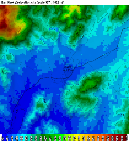
Below is the Elevation map of Ban Khok, which displays elevation range with different colors. Scale of the first map is from 387 to 1022 m (1270 to 3353 ft) with average elevation of 499.4 meters (=1638 ft) [note 1]
These maps also provides idea of topography and contour of this city, they are displayed at different zoom levels. More info about maps, scale and edge coordinates you can find below images.
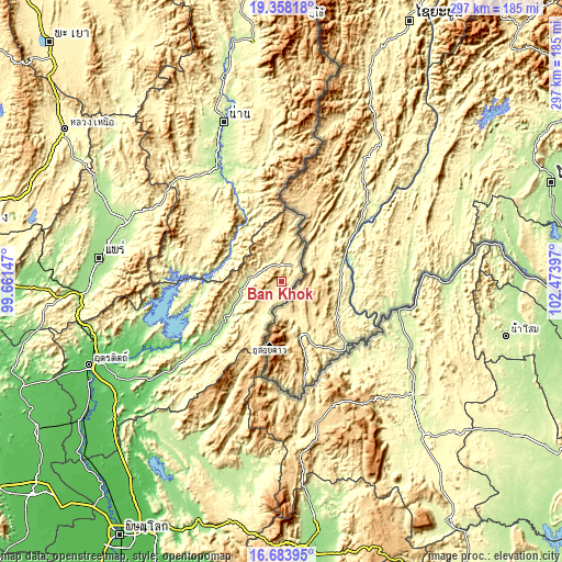
| \ | Map #1 | Topo.Map |
| Scale [m] | 387..1022 m | × |
| Scale [ft] | 1270..3353 ft | × |
| Average | 499.4 m = 1638 ft | × |
| Width | 9.29 km = 5.8 mi | 297.3 km = 184.7 mi |
| Height | 9.29 km = 5.8 mi | 297.4 km = 184.8 mi |
| ↑Max Latitude | 18.067923° | 19.35818° |
| Latitude at center | 18.02614° | 18.02614° |
| ↓Min Latitude | 17.984347° | 16.68395° |
| ← Min Longitude | 101.023775° | 99.66147° |
| Longitude center | 101.06772° | 101.06772° |
| →Max Longitude | 101.111665° | 102.47397° |
Nearby cities:
Cities around Ban Khok sort by population:
• Dan Sai elevation 357 m
83.4 km,  174°
174°
• Tha Pla 122 m
77.7 km,  250°
250°
• Mae Charim 289 m
75.9 km,  355°
355°
• Wiang Sa 210 m
72.4 km,  331°
331°
• Phu Ruea 632 m
70.9 km,  153°
153°
• Chiang Khan 218 m
64.3 km,  103°
103°
• Na Haeo 494 m
60.1 km,  179°
179°
• Tha Li 268 m
58.3 km,  140°
140°
• Nam Pat 155 m
52.4 km,  230°
230°
• Na Noi 274 m
50.1 km,  311°
311°
• Na Muen 351 m
46.7 km,  292°
292°
• Fak Tha 227 m
20.1 km,  261°
261°
Multilingual:
 En español:
Ban Khok elevación 433 m.
 En France:
Ban Khok élévation 433 m.
 Auf Deutsch:
Ban Khok höhe über dem Meeresspiegel ist 433 m.

Sources and notes:
- [note 1] Map square and city borders are not equal. Map elevation data is calculated only from area inside that square.
- [src 1] Elevation data from geonames database provided with same terms of usage.
- [src 2] The elevation map of Ban Khok is generated using elevation data from NASA's 3 arcsec (90m) resolution SRTM data.
- [src 3] Base (background) map © OpenStreetMap contributors tiles are generated by Geofabrik and OpenTopoMap.
Copyright & License:
This Ban Khok Elevation Map is licensed under CC BY-SA. You may reuse any part from this page, if you give a proper credit by linking to this URL:
 More info on terms of use page.