Na Noi elevation
Na Noi (Nan), Thailand elevation is 274 meters and Na Noi elevation in feet is 899 ft above sea level [src 1]. Na Noi is a seat of a second-order administrative division (feature code) with elevation that is 149 meters (489 ft) bigger than average city elevation in Thailand.
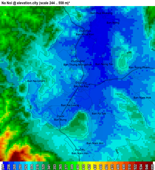
Below is the Elevation map of Na Noi, which displays elevation range with different colors. Scale of the first map is from 244 to 558 m (801 to 1831 ft) with average elevation of 304.5 meters (=999 ft) [note 1]
These maps also provides idea of topography and contour of this city, they are displayed at different zoom levels. More info about maps, scale and edge coordinates you can find below images.
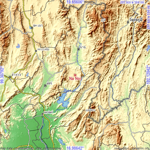
| \ | Map #1 | Topo.Map |
| Scale [m] | 244..558 m | × |
| Scale [ft] | 801..1831 ft | × |
| Average | 304.5 m = 999 ft | × |
| Width | 9.28 km = 5.8 mi | 296.8 km = 184.4 mi |
| Height | 9.28 km = 5.8 mi | 296.9 km = 184.5 mi |
| ↑Max Latitude | 18.368101° | 19.65606° |
| Latitude at center | 18.32639° | 18.32639° |
| ↓Min Latitude | 18.284669° | 16.98642° |
| ← Min Longitude | 100.670225° | 99.30792° |
| Longitude center | 100.71417° | 100.71417° |
| →Max Longitude | 100.758115° | 102.12042° |
Nearby cities:
Cities around Na Noi sort by population:
• Phrae elevation 162 m
63.8 km,  251°
251°
• Nan 205 m
51.3 km,  7°
7°
• Rong Kwang 212 m
41.9 km,  271°
271°
• Ban Luang 373 m
65.1 km,  333°
333°
• Song 189 m
58.3 km,  286°
286°
• Nong Muang Khai 166 m
55.8 km,  262°
262°
• Mae Charim 289 m
52.2 km,  36°
36°
• Ban Khok 433 m
50.1 km,  131°
131°
• Phu Phiang 221 m
47.1 km, 11°
• Fak Tha 227 m
40.4 km,  154°
154°
• Wiang Sa 210 m
30.4 km, 5°
• Na Muen 351 m
16.3 km,  200°
200°
Multilingual:
 En español:
Na Noi elevación 274 m.
 En France:
Na Noi élévation 274 m.


Sources and notes:
- [note 1] Map square and city borders are not equal. Map elevation data is calculated only from area inside that square.
- [src 1] Elevation data from geonames database provided with same terms of usage.
- [src 2] The elevation map of Na Noi is generated using elevation data from NASA's 3 arcsec (90m) resolution SRTM data.
- [src 3] Base (background) map © OpenStreetMap contributors tiles are generated by Geofabrik and OpenTopoMap.
Copyright & License:
This Na Noi Elevation Map is licensed under CC BY-SA. You may reuse any part from this page, if you give a proper credit by linking to this URL:
 More info on terms of use page.