Nan elevation
Nan, Thailand elevation is 205 meters and Nan elevation in feet is 673 ft above sea level [src 1]. Nan is a seat of a first-order administrative division (feature code) with elevation that is 80 meters (262 ft) bigger than average city elevation in Thailand.
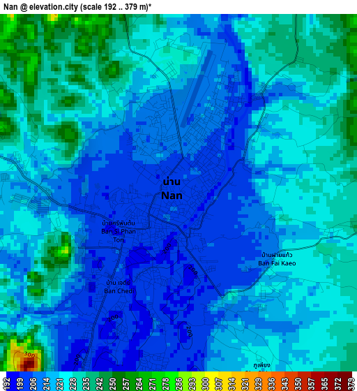
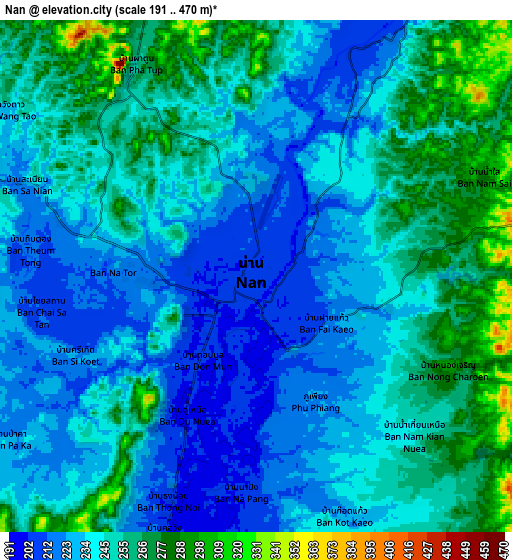
Below is the Elevation map of Nan, which displays elevation range with different colors. Scale of the first map is from 192 to 379 m (630 to 1243 ft) with average elevation of 219.9 meters (=721 ft) [note 1]
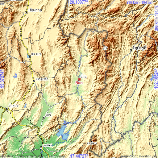
These maps also provides idea of topography and contour of this city, they are displayed at different zoom levels. More info about maps, scale and edge coordinates you can find below images.
| \ | Map #1 | Map #2 | Topo.Map |
| Scale [m] | 192..379 m | 191..470 m | × |
| Scale [ft] | 630..1243 ft | 627..1542 ft | × |
| Average | 219.9 m = 721 ft | 243.7 m = 800 ft | × |
| Width | 9.25 km = 5.7 mi | 18.5 km = 11.5 mi | 296 km = 183.9 mi |
| Height | 9.25 km = 5.7 mi | 18.5 km = 11.5 mi | 296.1 km = 184 mi |
| ↑Max Latitude | 18.82538° | 18.866969° | 20.10977° |
| Latitude at center | 18.78378° | 18.78378° | 18.78378° |
| ↓Min Latitude | 18.74217° | 18.70055° | 17.44727° |
| ← Min Longitude | 100.735045° | 100.691099° | 99.37274° |
| Longitude center | 100.77899° | 100.77899° | 100.77899° |
| →Max Longitude | 100.822935° | 100.866881° | 102.18524° |
Nearby cities:
Cities around Nan sort by population:
• Chiang Klang elevation 266 m
57.4 km,  8°
8°
• Song Khwae 299 m
64.6 km,  352°
352°
• Bo Kluea 674 m
56.8 km,  44°
44°
• Na Noi 274 m
51.3 km,  187°
187°
• Chiang Muan 275 m
51.2 km,  283°
283°
• Pua 290 m
45.8 km,  18°
18°
• Tha Wang Pha 234 m
37.7 km, 5°
• Ban Luang 373 m
36.7 km, 281°
• Mae Charim 289 m
25.4 km,  109°
109°
• Santi Suk 292 m
22.4 km,  49°
49°
• Wiang Sa 210 m
21 km, 190°
• Phu Phiang 221 m
5.1 km,  154°
154°
Multilingual:
 En español:
Nan elevación 205 m.
 En France:
Nan élévation 205 m.


Sources and notes:
- [note 1] Map square and city borders are not equal. Map elevation data is calculated only from area inside that square.
- [src 1] Elevation data from geonames database provided with same terms of usage.
- [src 2] The elevation map of Nan is generated using elevation data from NASA's 3 arcsec (90m) resolution SRTM data.
- [src 3] Base (background) map © OpenStreetMap contributors tiles are generated by Geofabrik and OpenTopoMap.
Copyright & License:
This Nan Elevation Map is licensed under CC BY-SA. You may reuse any part from this page, if you give a proper credit by linking to this URL:
 More info on terms of use page.