Phrae elevation
Phrae, Thailand elevation is 162 meters and Phrae elevation in feet is 531 ft above sea level [src 1]. Phrae is a seat of a first-order administrative division (feature code) with elevation that is 37 meters (121 ft) bigger than average city elevation in Thailand.
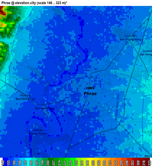
Below is the Elevation map of Phrae, which displays elevation range with different colors. Scale of the first map is from 146 to 323 m (479 to 1060 ft) with average elevation of 163.6 meters (=537 ft) [note 1]
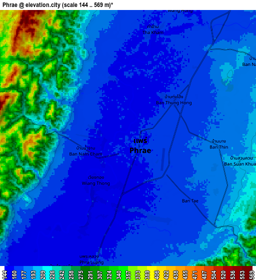
These maps also provides idea of topography and contour of this city, they are displayed at different zoom levels. More info about maps, scale and edge coordinates you can find below images.
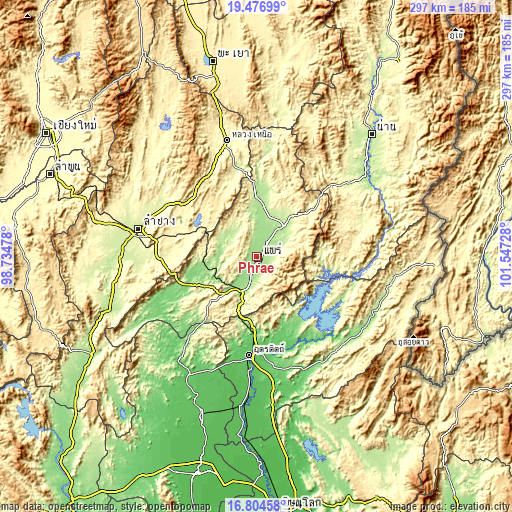
| \ | Map #1 | Map #2 | Topo.Map |
| Scale [m] | 146..323 m | 144..569 m | × |
| Scale [ft] | 479..1060 ft | 472..1867 ft | × |
| Average | 163.6 m = 537 ft | 201.5 m = 661 ft | × |
| Width | 9.29 km = 5.8 mi | 18.57 km = 11.5 mi | 297.1 km = 184.6 mi |
| Height | 9.29 km = 5.8 mi | 18.57 km = 11.5 mi | 297.2 km = 184.7 mi |
| ↑Max Latitude | 18.187645° | 18.22939° | 19.47699° |
| Latitude at center | 18.14589° | 18.14589° | 18.14589° |
| ↓Min Latitude | 18.104125° | 18.062351° | 16.80458° |
| ← Min Longitude | 100.097085° | 100.053139° | 98.73478° |
| Longitude center | 100.14103° | 100.14103° | 100.14103° |
| →Max Longitude | 100.184975° | 100.228921° | 101.54728° |
Nearby cities:
Cities around Phrae sort by population:
• Uttaradit elevation 68 m
58.1 km,  184°
184°
• Den Chai 159 m
20.3 km,  207°
207°
• Rong Kwang 212 m
28.4 km,  40°
40°
• Long 139 m
33.7 km,  256°
256°
• Lap Lae 85 m
56 km,  191°
191°
• Laplae 85 m
56 km, 191°
• Na Muen 351 m
55.1 km,  84°
84°
• Mae Mo 388 m
53.8 km,  285°
285°
• Tha Pla 122 m
46.6 km,  147°
147°
• Song 189 m
36.5 km,  7°
7°
• Nong Muang Khai 166 m
14.2 km,  21°
21°
• Sung Men 163 m
11.1 km, 194°
Multilingual:
 En español:
Phrae elevación 162 m.
 En France:
Phrae élévation 162 m.


Sources and notes:
- [note 1] Map square and city borders are not equal. Map elevation data is calculated only from area inside that square.
- [src 1] Elevation data from geonames database provided with same terms of usage.
- [src 2] The elevation map of Phrae is generated using elevation data from NASA's 3 arcsec (90m) resolution SRTM data.
- [src 3] Base (background) map © OpenStreetMap contributors tiles are generated by Geofabrik and OpenTopoMap.
Copyright & License:
This Phrae Elevation Map is licensed under CC BY-SA. You may reuse any part from this page, if you give a proper credit by linking to this URL:
 More info on terms of use page.