Long elevation
Long (Phrae), Thailand elevation is 139 meters and Long elevation in feet is 456 ft above sea level [src 1]. Long is a seat of a second-order administrative division (feature code) with elevation that is 14 meters (46 ft) bigger than average city elevation in Thailand.
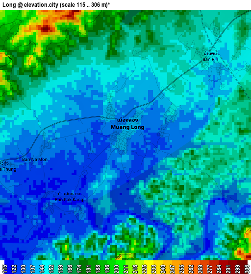
Below is the Elevation map of Long, which displays elevation range with different colors. Scale of the first map is from 115 to 306 m (377 to 1004 ft) with average elevation of 150.4 meters (=493 ft) [note 1]
These maps also provides idea of topography and contour of this city, they are displayed at different zoom levels. More info about maps, scale and edge coordinates you can find below images.
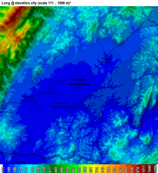
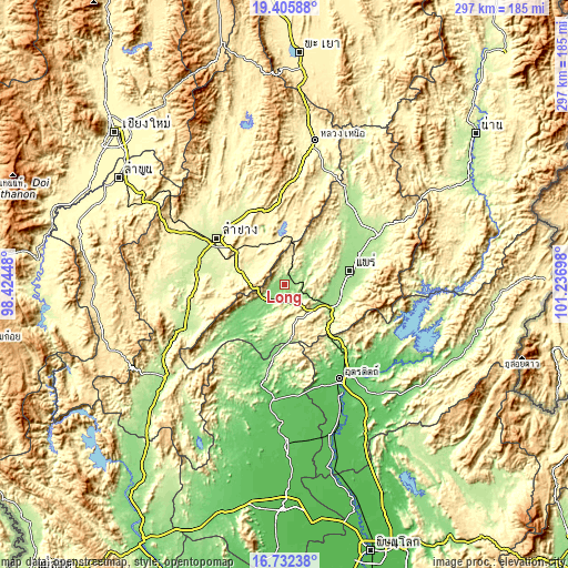
| \ | Map #1 | Map #2 | Topo.Map |
| Scale [m] | 115..306 m | 111..1086 m | × |
| Scale [ft] | 377..1004 ft | 364..3563 ft | × |
| Average | 150.4 m = 493 ft | 226.1 m = 742 ft | × |
| Width | 9.29 km = 5.8 mi | 18.58 km = 11.5 mi | 297.3 km = 184.7 mi |
| Height | 9.29 km = 5.8 mi | 18.58 km = 11.5 mi | 297.3 km = 184.7 mi |
| ↑Max Latitude | 18.115992° | 18.157754° | 19.40588° |
| Latitude at center | 18.07422° | 18.07422° | 18.07422° |
| ↓Min Latitude | 18.032438° | 17.990646° | 16.73238° |
| ← Min Longitude | 99.786785° | 99.742839° | 98.42448° |
| Longitude center | 99.83073° | 99.83073° | 99.83073° |
| →Max Longitude | 99.874675° | 99.918621° | 101.23698° |
Nearby cities:
Cities around Long sort by population:
• Lampang elevation 238 m
43.2 km,  304°
304°
• Phrae 162 m
33.7 km,  76°
76°
• Den Chai 159 m
25.5 km,  113°
113°
• Sop Prap 200 m
56.5 km,  247°
247°
• Lap Lae 85 m
51.8 km,  154°
154°
• Laplae 85 m
51.8 km, 154°
• Ko Kha 223 m
47.9 km,  285°
285°
• Nong Muang Khai 166 m
43.4 km,  60°
60°
• Mae Tha 250 m
34.1 km,  281°
281°
• Wang Chin 108 m
31.7 km,  227°
227°
• Sung Men 163 m
30.1 km,  95°
95°
• Mae Mo 388 m
29.4 km,  319°
319°
Multilingual:
 En español:
Long elevación 139 m.
 En France:
Long élévation 139 m.


Sources and notes:
- [note 1] Map square and city borders are not equal. Map elevation data is calculated only from area inside that square.
- [src 1] Elevation data from geonames database provided with same terms of usage.
- [src 2] The elevation map of Long is generated using elevation data from NASA's 3 arcsec (90m) resolution SRTM data.
- [src 3] Base (background) map © OpenStreetMap contributors tiles are generated by Geofabrik and OpenTopoMap.
Copyright & License:
This Long Elevation Map is licensed under CC BY-SA. You may reuse any part from this page, if you give a proper credit by linking to this URL:
 More info on terms of use page.