Wang Chin elevation
Wang Chin (Phrae, Amphoe Wang Chin), Thailand elevation is 108 meters and Wang Chin elevation in feet is 354 ft above sea level [src 1]. Wang Chin is a seat of a second-order administrative division (feature code) with elevation that is 17 meters (56 ft) smaller than average city elevation in Thailand.
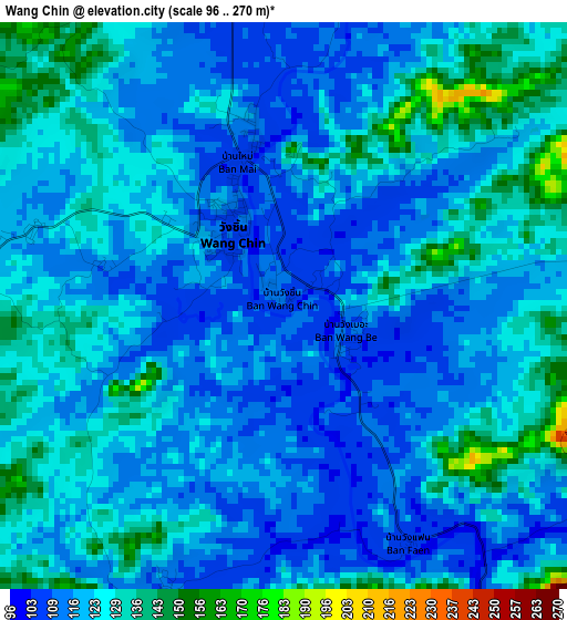
Below is the Elevation map of Wang Chin, which displays elevation range with different colors. Scale of the first map is from 96 to 270 m (315 to 886 ft) with average elevation of 121.9 meters (=400 ft) [note 1]
These maps also provides idea of topography and contour of this city, they are displayed at different zoom levels. More info about maps, scale and edge coordinates you can find below images.
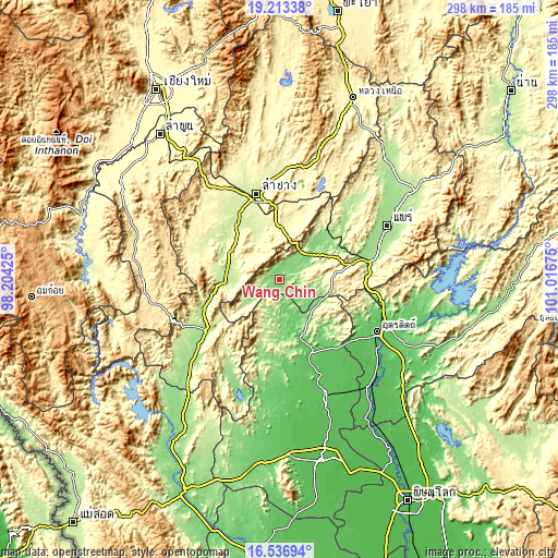
| \ | Map #1 | Topo.Map |
| Scale [m] | 96..270 m | × |
| Scale [ft] | 315..886 ft | × |
| Average | 121.9 m = 400 ft | × |
| Width | 9.3 km = 5.8 mi | 297.6 km = 184.9 mi |
| Height | 9.3 km = 5.8 mi | 297.6 km = 184.9 mi |
| ↑Max Latitude | 17.922018° | 19.21338° |
| Latitude at center | 17.8802° | 17.8802° |
| ↓Min Latitude | 17.838372° | 16.53694° |
| ← Min Longitude | 99.566555° | 98.20425° |
| Longitude center | 99.6105° | 99.6105° |
| →Max Longitude | 99.654445° | 101.01675° |
Nearby cities:
Cities around Wang Chin sort by population:
• Lampang elevation 238 m
47.5 km,  344°
344°
• Si Satchanalai 77 m
43.4 km,  158°
158°
• Thoen 170 m
51.3 km,  234°
234°
• Den Chai 159 m
48.1 km,  76°
76°
• Long 139 m
31.7 km,  47°
47°
• Lap Lae 85 m
52 km,  119°
119°
• Laplae 85 m
52 km, 119°
• Mae Mo 388 m
44.2 km,  5°
5°
• Soem Ngam 248 m
43.7 km,  298°
298°
• Ko Kha 223 m
41.5 km,  326°
326°
• Mae Tha 250 m
30 km, 340°
• Sop Prap 200 m
28.9 km,  270°
270°
Multilingual:
 En español:
Wang Chin elevación 108 m.
 En France:
Wang Chin élévation 108 m.
 Auf Deutsch:
Wang Chin höhe über dem Meeresspiegel ist 108 m.

Sources and notes:
- [note 1] Map square and city borders are not equal. Map elevation data is calculated only from area inside that square.
- [src 1] Elevation data from geonames database provided with same terms of usage.
- [src 2] The elevation map of Wang Chin is generated using elevation data from NASA's 3 arcsec (90m) resolution SRTM data.
- [src 3] Base (background) map © OpenStreetMap contributors tiles are generated by Geofabrik and OpenTopoMap.
Copyright & License:
This Wang Chin Elevation Map is licensed under CC BY-SA. You may reuse any part from this page, if you give a proper credit by linking to this URL:
 More info on terms of use page.