Lampang elevation
Lampang, Thailand elevation is 238 meters and Lampang elevation in feet is 781 ft above sea level [src 1]. Lampang is a seat of a first-order administrative division (feature code) with elevation that is 113 meters (371 ft) bigger than average city elevation in Thailand.
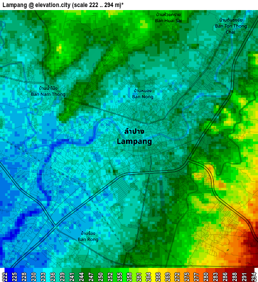
Below is the Elevation map of Lampang, which displays elevation range with different colors. Scale of the first map is from 222 to 294 m (728 to 965 ft) with average elevation of 243 meters (=797 ft) [note 1]
These maps also provides idea of topography and contour of this city, they are displayed at different zoom levels. More info about maps, scale and edge coordinates you can find below images.
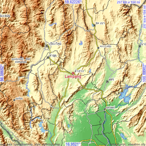
| \ | Map #1 | Map #2 | Topo.Map |
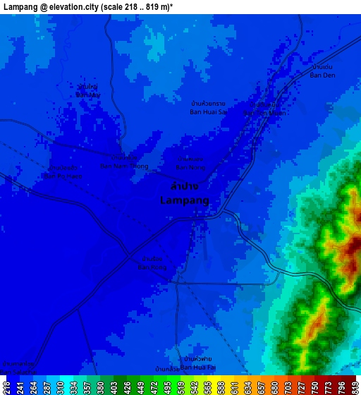
| Scale [m] | 222..294 m | 218..819 m | × |
| Scale [ft] | 728..965 ft | 715..2687 ft | × |
| Average | 243 m = 797 ft | 272.2 m = 893 ft | × |
| Width | 9.28 km = 5.8 mi | 18.56 km = 11.5 mi | 296.9 km = 184.5 mi |
| Height | 9.28 km = 5.8 mi | 18.56 km = 11.5 mi | 296.9 km = 184.5 mi |
| ↑Max Latitude | 18.33404° | 18.375749° | 19.62226° |
| Latitude at center | 18.29232° | 18.29232° | 18.29232° |
| ↓Min Latitude | 18.25059° | 18.208851° | 16.9521° |
| ← Min Longitude | 99.448825° | 99.404879° | 98.08652° |
| Longitude center | 99.49277° | 99.49277° | 99.49277° |
| →Max Longitude | 99.536715° | 99.580661° | 100.89902° |
Nearby cities:
Cities around Lampang sort by population:
• Long elevation 139 m
43.2 km,  124°
124°
• Mae Tha 406 m
41.8 km,  297°
297°
• Ban Thi 309 m
54.8 km,  313°
313°
• Mueang Pan 393 m
52.9 km,  1°
1°
• Sop Prap 200 m
48.7 km,  199°
199°
• Wang Chin 108 m
47.5 km,  164°
164°
• Chae Hom 326 m
47.2 km,  8°
8°
• Soem Ngam 248 m
36.4 km,  225°
225°
• Mae Tha 250 m
17.7 km,  172°
172°
• Mae Mo 388 m
16.8 km,  96°
96°
• Hang Chat 280 m
16 km,  284°
284°
• Ko Kha 223 m
15.2 km,  223°
223°
Multilingual:
 En español:
Lampang elevación 238 m.
 En France:
Lampang élévation 238 m.


Sources and notes:
- [note 1] Map square and city borders are not equal. Map elevation data is calculated only from area inside that square.
- [src 1] Elevation data from geonames database provided with same terms of usage.
- [src 2] The elevation map of Lampang is generated using elevation data from NASA's 3 arcsec (90m) resolution SRTM data.
- [src 3] Base (background) map © OpenStreetMap contributors tiles are generated by Geofabrik and OpenTopoMap.
Copyright & License:
This Lampang Elevation Map is licensed under CC BY-SA. You may reuse any part from this page, if you give a proper credit by linking to this URL:
 More info on terms of use page.