Mae Tha elevation
Mae Tha (Lamphun), Thailand elevation is 406 meters and Mae Tha elevation in feet is 1332 ft above sea level [src 1]. Mae Tha is a seat of a second-order administrative division (feature code) with elevation that is 281 meters (922 ft) bigger than average city elevation in Thailand.
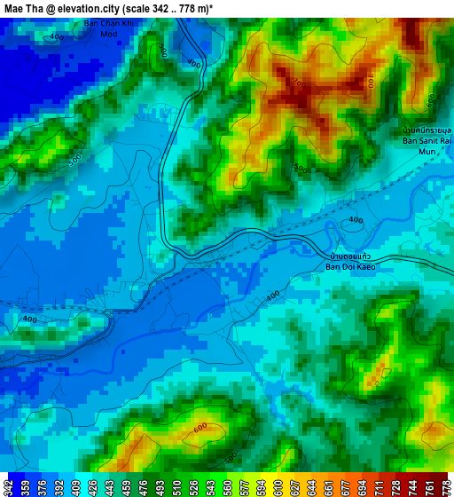
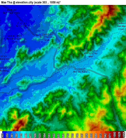
Below is the Elevation map of Mae Tha, which displays elevation range with different colors. Scale of the first map is from 342 to 778 m (1122 to 2552 ft) with average elevation of 458.5 meters (=1504 ft) [note 1]
These maps also provides idea of topography and contour of this city, they are displayed at different zoom levels. More info about maps, scale and edge coordinates you can find below images.
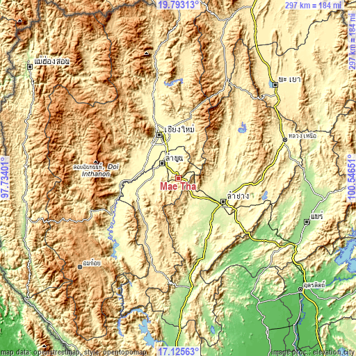
| \ | Map #1 | Map #2 | Topo.Map |
| Scale [m] | 342..778 m | 303..1058 m | × |
| Scale [ft] | 1122..2552 ft | 994..3471 ft | × |
| Average | 458.5 m = 1504 ft | 501 m = 1644 ft | × |
| Width | 9.27 km = 5.8 mi | 18.54 km = 11.5 mi | 296.6 km = 184.3 mi |
| Height | 9.27 km = 5.8 mi | 18.54 km = 11.5 mi | 296.6 km = 184.3 mi |
| ↑Max Latitude | 18.506238° | 18.547906° | 19.79313° |
| Latitude at center | 18.46456° | 18.46456° | 18.46456° |
| ↓Min Latitude | 18.422872° | 18.381174° | 17.12563° |
| ← Min Longitude | 99.096315° | 99.052369° | 97.73401° |
| Longitude center | 99.14026° | 99.14026° | 99.14026° |
| →Max Longitude | 99.184205° | 99.228151° | 100.54651° |
Nearby cities:
Cities around Mae Tha sort by population:
• Chiang Mai elevation 313 m
39.8 km,  335°
335°
• Lamphun 296 m
19 km,  312°
312°
• San Kamphaeng 311 m
31.2 km,  355°
355°
• Hang Dong 311 m
34 km,  316°
316°
• San Pa Tong 300 m
31.6 km, 305°
• Pa Sang 295 m
22.3 km,  287°
287°
• Doi Lo 303 m
38.2 km,  269°
269°
• Ban Hong 322 m
37 km,  246°
246°
• Mae On 401 m
36.5 km,  18°
18°
• Saraphi 303 m
29.9 km, 338°
• Hang Chat 280 m
26.5 km,  124°
124°
• Ban Thi 309 m
18.8 km,  352°
352°
Multilingual:
 En español:
Mae Tha elevación 406 m.
 En France:
Mae Tha élévation 406 m.


Sources and notes:
- [note 1] Map square and city borders are not equal. Map elevation data is calculated only from area inside that square.
- [src 1] Elevation data from geonames database provided with same terms of usage.
- [src 2] The elevation map of Mae Tha is generated using elevation data from NASA's 3 arcsec (90m) resolution SRTM data.
- [src 3] Base (background) map © OpenStreetMap contributors tiles are generated by Geofabrik and OpenTopoMap.
Copyright & License:
This Mae Tha Elevation Map is licensed under CC BY-SA. You may reuse any part from this page, if you give a proper credit by linking to this URL:
 More info on terms of use page.