Chiang Mai elevation
Chiang Mai, Thailand elevation is 313 meters and Chiang Mai elevation in feet is 1027 ft above sea level [src 1]. Chiang Mai is a seat of a first-order administrative division (feature code) with elevation that is 188 meters (617 ft) bigger than average city elevation in Thailand.
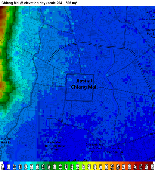
Below is the Elevation map of Chiang Mai, which displays elevation range with different colors. Scale of the first map is from 294 to 596 m (965 to 1955 ft) with average elevation of 320.3 meters (=1051 ft) [note 1]
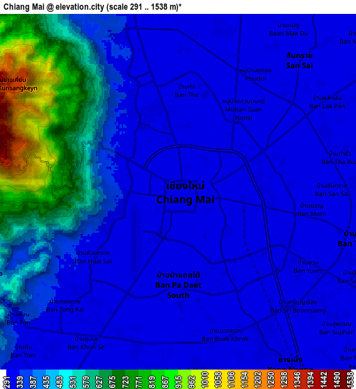
These maps also provides idea of topography and contour of this city, they are displayed at different zoom levels. More info about maps, scale and edge coordinates you can find below images.
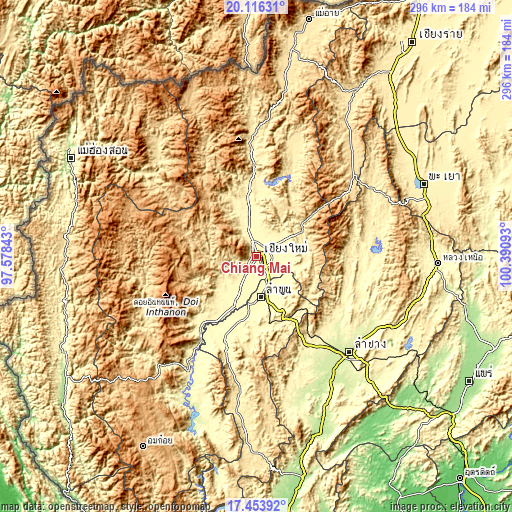
| \ | Map #1 | Map #2 | Topo.Map |
| Scale [m] | 294..596 m | 291..1538 m | × |
| Scale [ft] | 965..1955 ft | 955..5046 ft | × |
| Average | 320.3 m = 1051 ft | 402.3 m = 1320 ft | × |
| Width | 9.25 km = 5.7 mi | 18.5 km = 11.5 mi | 296 km = 183.9 mi |
| Height | 9.25 km = 5.7 mi | 18.5 km = 11.5 mi | 296.1 km = 184 mi |
| ↑Max Latitude | 18.831978° | 18.873566° | 20.11631° |
| Latitude at center | 18.79038° | 18.79038° | 18.79038° |
| ↓Min Latitude | 18.748772° | 18.707153° | 17.45392° |
| ← Min Longitude | 98.940735° | 98.896789° | 97.57843° |
| Longitude center | 98.98468° | 98.98468° | 98.98468° |
| →Max Longitude | 99.028625° | 99.072571° | 100.39093° |
Nearby cities:
Cities around Chiang Mai sort by population:
• Lamphun elevation 296 m
23.5 km,  174°
174°
• San Kamphaeng 311 m
15.1 km,  109°
109°
• Hang Dong 311 m
13.4 km,  210°
210°
• San Pa Tong 300 m
20.3 km, 207°
• Pa Sang 295 m
29.8 km,  189°
189°
• Mae Taeng 336 m
36.6 km,  352°
352°
• Mae Wang 335 m
29.5 km,  229°
229°
• Mae On 401 m
27.8 km,  93°
93°
• Samoeng 507 m
27.3 km,  283°
283°
• Ban Thi 309 m
22.4 km,  141°
141°
• Saraphi 303 m
10 km,  147°
147°
• San Sai 316 m
9 km,  44°
44°
Multilingual:
 En español:
Chiang Mai elevación 313 m.
 En France:
Chiang Mai élévation 313 m.
 Auf Deutsch:
Chiang Mai höhe über dem Meeresspiegel ist 313 m.

Sources and notes:
- [note 1] Map square and city borders are not equal. Map elevation data is calculated only from area inside that square.
- [src 1] Elevation data from geonames database provided with same terms of usage.
- [src 2] The elevation map of Chiang Mai is generated using elevation data from NASA's 3 arcsec (90m) resolution SRTM data.
- [src 3] Base (background) map © OpenStreetMap contributors tiles are generated by Geofabrik and OpenTopoMap.
Copyright & License:
This Chiang Mai Elevation Map is licensed under CC BY-SA. You may reuse any part from this page, if you give a proper credit by linking to this URL:
 More info on terms of use page.