Mueang Pan elevation
Mueang Pan (Lampang), Thailand elevation is 393 meters and Mueang Pan elevation in feet is 1289 ft above sea level [src 1]. Mueang Pan is a seat of a second-order administrative division (feature code) with elevation that is 268 meters (879 ft) bigger than average city elevation in Thailand.
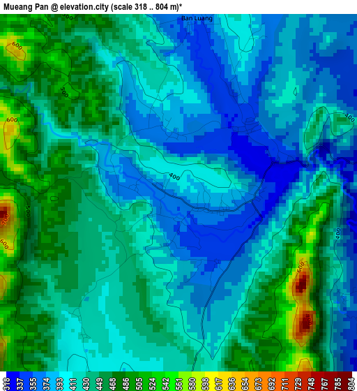
Below is the Elevation map of Mueang Pan, which displays elevation range with different colors. Scale of the first map is from 318 to 804 m (1043 to 2638 ft) with average elevation of 423.1 meters (=1388 ft) [note 1]
These maps also provides idea of topography and contour of this city, they are displayed at different zoom levels. More info about maps, scale and edge coordinates you can find below images.
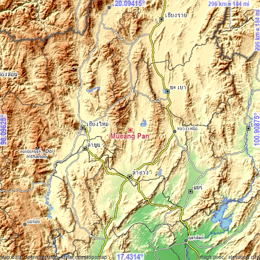
| \ | Map #1 | Topo.Map |
| Scale [m] | 318..804 m | × |
| Scale [ft] | 1043..2638 ft | × |
| Average | 423.1 m = 1388 ft | × |
| Width | 9.25 km = 5.7 mi | 296.1 km = 184 mi |
| Height | 9.25 km = 5.7 mi | 296.1 km = 184 mi |
| ↑Max Latitude | 18.809634° | 20.09415° |
| Latitude at center | 18.76803° | 18.76803° |
| ↓Min Latitude | 18.726416° | 17.4314° |
| ← Min Longitude | 99.458555° | 98.09625° |
| Longitude center | 99.5025° | 99.5025° |
| →Max Longitude | 99.546445° | 100.90875° |
Nearby cities:
Cities around Mueang Pan sort by population:
• Chiang Mai elevation 313 m
54.6 km,  272°
272°
• Lampang 238 m
52.9 km,  181°
181°
• San Kamphaeng 311 m
40.4 km, 266°
• Mae Tha 406 m
50.9 km,  228°
228°
• Hang Chat 280 m
51.5 km,  198°
198°
• Ngao 283 m
50.1 km,  91°
91°
• Saraphi 303 m
49.6 km,  263°
263°
• San Sai 316 m
49 km,  280°
280°
• Wang Nuea 420 m
43.9 km,  16°
16°
• Ban Thi 309 m
43.4 km,  249°
249°
• Mae On 401 m
26.7 km, 272°
• Chae Hom 326 m
8.5 km,  136°
136°
Multilingual:
 En español:
Mueang Pan elevación 393 m.
 En France:
Mueang Pan élévation 393 m.
 Auf Deutsch:
Mueang Pan höhe über dem Meeresspiegel ist 393 m.

Sources and notes:
- [note 1] Map square and city borders are not equal. Map elevation data is calculated only from area inside that square.
- [src 1] Elevation data from geonames database provided with same terms of usage.
- [src 2] The elevation map of Mueang Pan is generated using elevation data from NASA's 3 arcsec (90m) resolution SRTM data.
- [src 3] Base (background) map © OpenStreetMap contributors tiles are generated by Geofabrik and OpenTopoMap.
Copyright & License:
This Mueang Pan Elevation Map is licensed under CC BY-SA. You may reuse any part from this page, if you give a proper credit by linking to this URL:
 More info on terms of use page.