Erawan elevation
Erawan (Loei), Thailand elevation is 358 meters and Erawan elevation in feet is 1175 ft above sea level [src 1]. Erawan is a seat of a second-order administrative division (feature code) with elevation that is 233 meters (764 ft) bigger than average city elevation in Thailand.
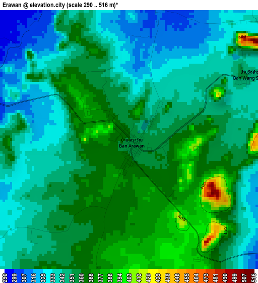
Below is the Elevation map of Erawan, which displays elevation range with different colors. Scale of the first map is from 290 to 516 m (951 to 1693 ft) with average elevation of 350.9 meters (=1151 ft) [note 1]
These maps also provides idea of topography and contour of this city, they are displayed at different zoom levels. More info about maps, scale and edge coordinates you can find below images.
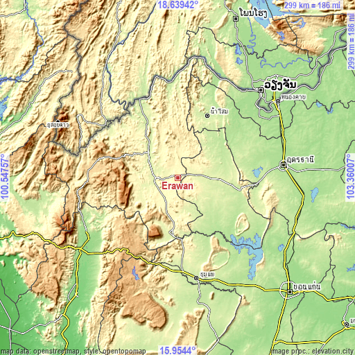
| \ | Map #1 | Topo.Map |
| Scale [m] | 290..516 m | × |
| Scale [ft] | 951..1693 ft | × |
| Average | 350.9 m = 1151 ft | × |
| Width | 9.33 km = 5.8 mi | 298.5 km = 185.5 mi |
| Height | 9.33 km = 5.8 mi | 298.6 km = 185.5 mi |
| ↑Max Latitude | 17.343762° | 18.63942° |
| Latitude at center | 17.30181° | 17.30181° |
| ↓Min Latitude | 17.259848° | 15.9544° |
| ← Min Longitude | 101.909875° | 100.54757° |
| Longitude center | 101.95382° | 101.95382° |
| →Max Longitude | 101.997765° | 103.36007° |
Nearby cities:
Cities around Erawan sort by population:
• Loei elevation 244 m
31.9 km,  311°
311°
• Nong Bua Lamphu 217 m
52.8 km,  101°
101°
• Na Klang 253 m
25 km,  88°
88°
• Phu Kradueng 268 m
47 km,  188°
188°
• Wang Saphung 254 m
19.7 km,  269°
269°
• Si Bun Rueang 211 m
50.6 km,  137°
137°
• Suwannakhuha 225 m
45.2 km,  49°
49°
• Suwanna Khuha 225 m
45.2 km, 49°
• Phu Luang 277 m
35.7 km,  239°
239°
• Pha Khao 256 m
27.5 km,  162°
162°
• Nong Hin 323 m
22.3 km,  207°
207°
• Na Wang 266 m
13.5 km,  79°
79°
Multilingual:
 En español:
Erawan elevación 358 m.
 En France:
Erawan élévation 358 m.


Sources and notes:
- [note 1] Map square and city borders are not equal. Map elevation data is calculated only from area inside that square.
- [src 1] Elevation data from geonames database provided with same terms of usage.
- [src 2] The elevation map of Erawan is generated using elevation data from NASA's 3 arcsec (90m) resolution SRTM data.
- [src 3] Base (background) map © OpenStreetMap contributors tiles are generated by Geofabrik and OpenTopoMap.
Copyright & License:
This Erawan Elevation Map is licensed under CC BY-SA. You may reuse any part from this page, if you give a proper credit by linking to this URL:
 More info on terms of use page.