Chat Trakan elevation
Chat Trakan (Phitsanulok), Thailand elevation is 210 meters and Chat Trakan elevation in feet is 689 ft above sea level [src 1]. Chat Trakan is a seat of a second-order administrative division (feature code) with elevation that is 85 meters (279 ft) bigger than average city elevation in Thailand.
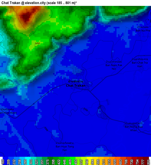
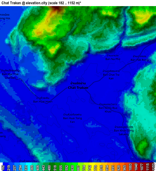
Below is the Elevation map of Chat Trakan, which displays elevation range with different colors. Scale of the first map is from 185 to 801 m (607 to 2628 ft) with average elevation of 257.7 meters (=845 ft) [note 1]
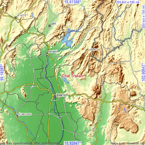
These maps also provides idea of topography and contour of this city, they are displayed at different zoom levels. More info about maps, scale and edge coordinates you can find below images.
| \ | Map #1 | Map #2 | Topo.Map |
| Scale [m] | 185..801 m | 182..1152 m | × |
| Scale [ft] | 607..2628 ft | 597..3780 ft | × |
| Average | 257.7 m = 845 ft | 310.1 m = 1017 ft | × |
| Width | 9.33 km = 5.8 mi | 18.66 km = 11.6 mi | 298.6 km = 185.5 mi |
| Height | 9.33 km = 5.8 mi | 18.66 km = 11.6 mi | 298.6 km = 185.5 mi |
| ↑Max Latitude | 17.318018° | 17.359966° | 18.61386° |
| Latitude at center | 17.27606° | 17.27606° | 17.27606° |
| ↓Min Latitude | 17.234093° | 17.192115° | 15.92847° |
| ← Min Longitude | 100.556275° | 100.512329° | 99.19397° |
| Longitude center | 100.60022° | 100.60022° | 100.60022° |
| →Max Longitude | 100.644165° | 100.688111° | 102.00647° |
Nearby cities:
Cities around Chat Trakan sort by population:
• Phitsanulok elevation 50 m
61.9 km,  215°
215°
• Nakhon Thai 211 m
31.9 km,  127°
127°
• Tha Pla 122 m
62 km,  337°
337°
• Dan Sai 357 m
58 km,  89°
89°
• Tron 64 m
56.6 km,  293°
293°
• Na Haeo 494 m
54.8 km,  64°
64°
• Phichai 60 m
54.5 km,  271°
271°
• Wang Thong 50 m
53.4 km,  199°
199°
• Nam Pat 155 m
51 km,  10°
10°
• Phrom Phiram 51 m
50.2 km,  237°
237°
• Wat Bot 49 m
43.4 km, 221°
• Thong Saen Khan 83 m
35.8 km,  307°
307°
Multilingual:
 En español:
Chat Trakan elevación 210 m.
 En France:
Chat Trakan élévation 210 m.
 Auf Deutsch:
Chat Trakan höhe über dem Meeresspiegel ist 210 m.

Sources and notes:
- [note 1] Map square and city borders are not equal. Map elevation data is calculated only from area inside that square.
- [src 1] Elevation data from geonames database provided with same terms of usage.
- [src 2] The elevation map of Chat Trakan is generated using elevation data from NASA's 3 arcsec (90m) resolution SRTM data.
- [src 3] Base (background) map © OpenStreetMap contributors tiles are generated by Geofabrik and OpenTopoMap.
Copyright & License:
This Chat Trakan Elevation Map is licensed under CC BY-SA. You may reuse any part from this page, if you give a proper credit by linking to this URL:
 More info on terms of use page.