Wat Bot elevation
Wat Bot (Phitsanulok), Thailand elevation is 49 meters and Wat Bot elevation in feet is 161 ft above sea level [src 1]. Wat Bot is a seat of a second-order administrative division (feature code) with elevation that is 76 meters (249 ft) smaller than average city elevation in Thailand.
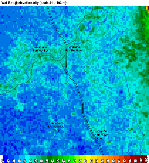
Below is the Elevation map of Wat Bot, which displays elevation range with different colors. Scale of the first map is from 41 to 103 m (135 to 338 ft) with average elevation of 50.4 meters (=165 ft) [note 1]
These maps also provides idea of topography and contour of this city, they are displayed at different zoom levels. More info about maps, scale and edge coordinates you can find below images.
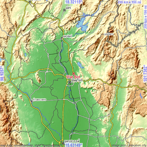
| \ | Map #1 | Topo.Map |
| Scale [m] | 41..103 m | × |
| Scale [ft] | 135..338 ft | × |
| Average | 50.4 m = 165 ft | × |
| Width | 9.35 km = 5.8 mi | 299.1 km = 185.9 mi |
| Height | 9.35 km = 5.8 mi | 299.1 km = 185.9 mi |
| ↑Max Latitude | 17.023165° | 18.32115° |
| Latitude at center | 16.98114° | 16.98114° |
| ↓Min Latitude | 16.939106° | 15.63149° |
| ← Min Longitude | 100.288005° | 98.9257° |
| Longitude center | 100.33195° | 100.33195° |
| →Max Longitude | 100.375895° | 101.7382° |
Nearby cities:
Cities around Wat Bot sort by population:
• Phitsanulok elevation 50 m
19.1 km,  204°
204°
• Sukhothai 53 m
54.2 km,  273°
273°
• Bang Krathum 45 m
44.9 km,  184°
184°
• Bang Rakam 47 m
33.7 km,  222°
222°
• Chat Trakan 210 m
43.4 km,  41°
41°
• Sam Ngam 44 m
54.5 km,  194°
194°
• Thong Saen Khan 83 m
54.4 km,  359°
359°
• Si Samrong 59 m
53.9 km,  292°
292°
• Phichai 60 m
42.9 km,  322°
322°
• Kong Krailat 46 m
37.8 km, 265°
• Wang Thong 50 m
20.3 km,  149°
149°
• Phrom Phiram 51 m
15 km, 292°
Multilingual:
 En español:
Wat Bot elevación 49 m.
 En France:
Wat Bot élévation 49 m.


Sources and notes:
- [note 1] Map square and city borders are not equal. Map elevation data is calculated only from area inside that square.
- [src 1] Elevation data from geonames database provided with same terms of usage.
- [src 2] The elevation map of Wat Bot is generated using elevation data from NASA's 3 arcsec (90m) resolution SRTM data.
- [src 3] Base (background) map © OpenStreetMap contributors tiles are generated by Geofabrik and OpenTopoMap.
Copyright & License:
This Wat Bot Elevation Map is licensed under CC BY-SA. You may reuse any part from this page, if you give a proper credit by linking to this URL:
 More info on terms of use page.