Bang Krathum elevation
Bang Krathum (Phitsanulok), Thailand elevation is 45 meters and Bang Krathum elevation in feet is 148 ft above sea level [src 1]. Bang Krathum is a seat of a second-order administrative division (feature code) with elevation that is 80 meters (262 ft) smaller than average city elevation in Thailand.
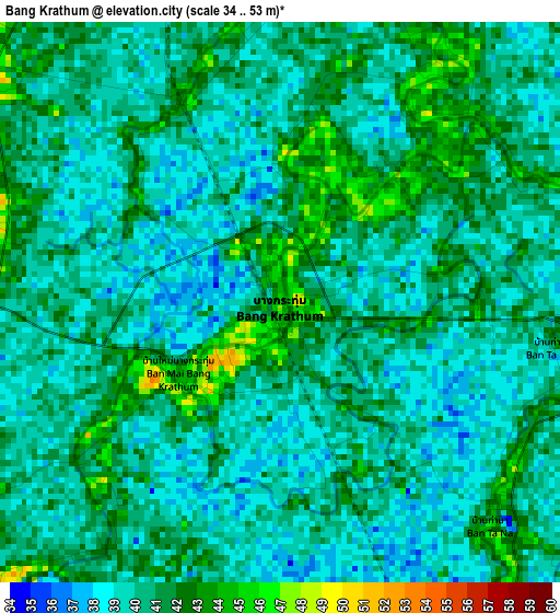
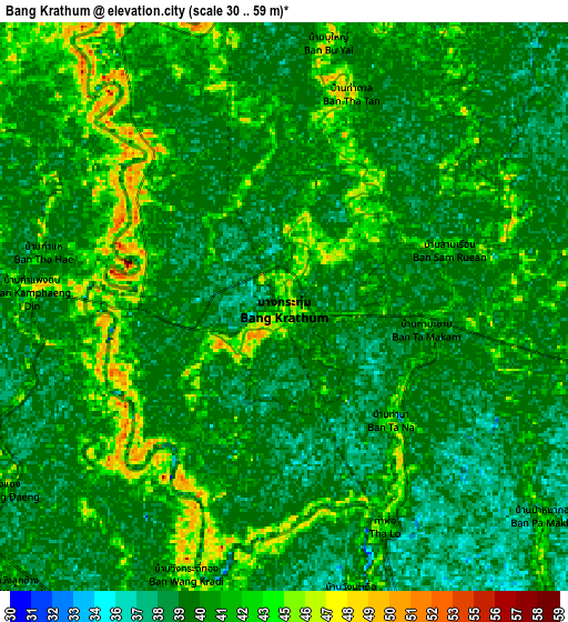
Below is the Elevation map of Bang Krathum, which displays elevation range with different colors. Scale of the first map is from 34 to 53 m (112 to 174 ft) with average elevation of 40.2 meters (=132 ft) [note 1]
These maps also provides idea of topography and contour of this city, they are displayed at different zoom levels. More info about maps, scale and edge coordinates you can find below images.
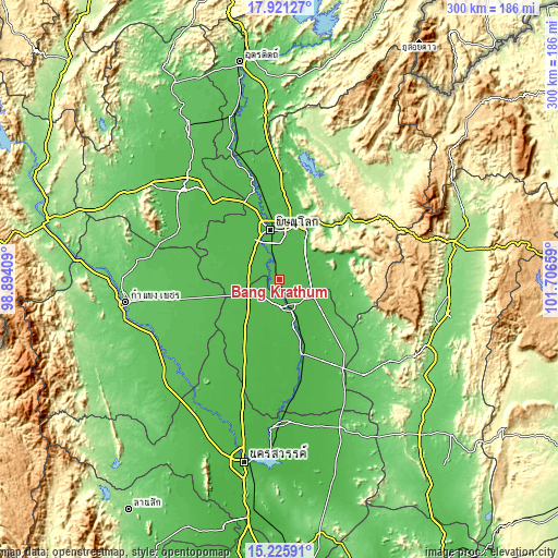
| \ | Map #1 | Map #2 | Topo.Map |
| Scale [m] | 34..53 m | 30..59 m | × |
| Scale [ft] | 112..174 ft | 98..194 ft | × |
| Average | 40.2 m = 132 ft | 40.5 m = 133 ft | × |
| Width | 9.37 km = 5.8 mi | 18.73 km = 11.6 mi | 299.7 km = 186.2 mi |
| Height | 9.37 km = 5.8 mi | 18.73 km = 11.6 mi | 299.7 km = 186.2 mi |
| ↑Max Latitude | 16.620424° | 16.662529° | 17.92127° |
| Latitude at center | 16.57831° | 16.57831° | 16.57831° |
| ↓Min Latitude | 16.536187° | 16.494055° | 15.22591° |
| ← Min Longitude | 100.256395° | 100.212449° | 98.89409° |
| Longitude center | 100.30034° | 100.30034° | 100.30034° |
| →Max Longitude | 100.344285° | 100.388231° | 101.70659° |
Nearby cities:
Cities around Bang Krathum sort by population:
• Phitsanulok elevation 50 m
27.8 km,  350°
350°
• Phichit 44 m
16 km,  161°
161°
• Taphan Hin 36 m
41.7 km, 162°
• Bang Rakam 47 m
27.9 km,  315°
315°
• Wang Sai Phun 50 m
33 km,  129°
129°
• Sai Ngam 59 m
45.6 km,  254°
254°
• Wat Bot 49 m
44.9 km,  4°
4°
• Noen Maprang 60 m
35.5 km,  92°
92°
• Wang Thong 50 m
30.6 km,  26°
26°
• Sak Lek 40 m
19.9 km,  114°
114°
• Wachira Barami 40 m
17.7 km, 249°
• Sam Ngam 44 m
12.9 km,  231°
231°
Multilingual:
 En español:
Bang Krathum elevación 45 m.
 En France:
Bang Krathum élévation 45 m.
 Auf Deutsch:
Bang Krathum höhe über dem Meeresspiegel ist 45 m.

Sources and notes:
- [note 1] Map square and city borders are not equal. Map elevation data is calculated only from area inside that square.
- [src 1] Elevation data from geonames database provided with same terms of usage.
- [src 2] The elevation map of Bang Krathum is generated using elevation data from NASA's 3 arcsec (90m) resolution SRTM data.
- [src 3] Base (background) map © OpenStreetMap contributors tiles are generated by Geofabrik and OpenTopoMap.
Copyright & License:
This Bang Krathum Elevation Map is licensed under CC BY-SA. You may reuse any part from this page, if you give a proper credit by linking to this URL:
 More info on terms of use page.