Phichit elevation
Phichit, Thailand elevation is 44 meters and Phichit elevation in feet is 144 ft above sea level [src 1]. Phichit is a seat of a first-order administrative division (feature code) with elevation that is 81 meters (266 ft) smaller than average city elevation in Thailand.
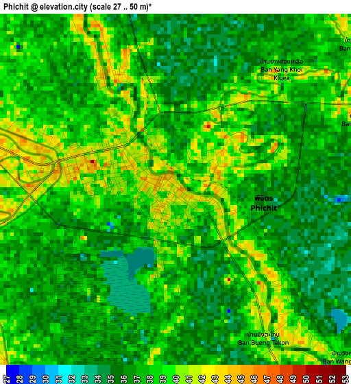
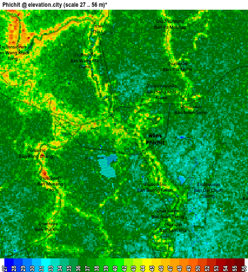
Below is the Elevation map of Phichit, which displays elevation range with different colors. Scale of the first map is from 27 to 50 m (89 to 164 ft) with average elevation of 37.5 meters (=123 ft) [note 1]
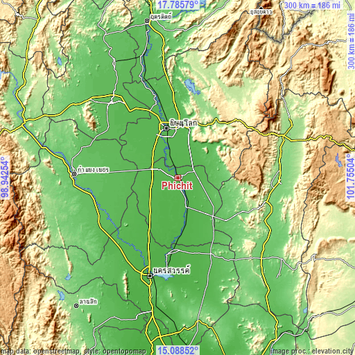
These maps also provides idea of topography and contour of this city, they are displayed at different zoom levels. More info about maps, scale and edge coordinates you can find below images.
| \ | Map #1 | Map #2 | Topo.Map |
| Scale [m] | 27..50 m | 27..56 m | × |
| Scale [ft] | 89..164 ft | 89..184 ft | × |
| Average | 37.5 m = 123 ft | 37.4 m = 123 ft | × |
| Width | 9.37 km = 5.8 mi | 18.75 km = 11.7 mi | 299.9 km = 186.3 mi |
| Height | 9.37 km = 5.8 mi | 18.75 km = 11.7 mi | 299.9 km = 186.3 mi |
| ↑Max Latitude | 16.483984° | 16.526118° | 17.78579° |
| Latitude at center | 16.44184° | 16.44184° | 16.44184° |
| ↓Min Latitude | 16.399687° | 16.357525° | 15.08852° |
| ← Min Longitude | 100.304845° | 100.260899° | 98.94254° |
| Longitude center | 100.34879° | 100.34879° | 100.34879° |
| →Max Longitude | 100.392735° | 100.436681° | 101.75504° |
Nearby cities:
Cities around Phichit sort by population:
• Taphan Hin elevation 36 m
25.7 km,  162°
162°
• Bang Krathum 45 m
16 km,  341°
341°
• Bang Rakam 47 m
43 km,  324°
324°
• Thap Khlo 51 m
41 km,  139°
139°
• Wang Sai Phun 50 m
21 km,  106°
106°
• Bueng Na Rang 37 m
38.4 km,  218°
218°
• Wang Thong 50 m
43.4 km,  11°
11°
• Pho Thale 35 m
39.9 km,  193°
193°
• Noen Maprang 60 m
33.4 km,  65°
65°
• Wachira Barami 40 m
23.6 km,  292°
292°
• Sam Ngam 44 m
16.9 km,  295°
295°
• Sak Lek 40 m
14.8 km,  61°
61°
Multilingual:
 En español:
Phichit elevación 44 m.
 En France:
Phichit élévation 44 m.


Sources and notes:
- [note 1] Map square and city borders are not equal. Map elevation data is calculated only from area inside that square.
- [src 1] Elevation data from geonames database provided with same terms of usage.
- [src 2] The elevation map of Phichit is generated using elevation data from NASA's 3 arcsec (90m) resolution SRTM data.
- [src 3] Base (background) map © OpenStreetMap contributors tiles are generated by Geofabrik and OpenTopoMap.
Copyright & License:
This Phichit Elevation Map is licensed under CC BY-SA. You may reuse any part from this page, if you give a proper credit by linking to this URL:
 More info on terms of use page.