Bueng Na Rang elevation
Bueng Na Rang (Phichit), Thailand elevation is 37 meters and Bueng Na Rang elevation in feet is 121 ft above sea level [src 1]. Bueng Na Rang is a seat of a second-order administrative division (feature code) with elevation that is 88 meters (289 ft) smaller than average city elevation in Thailand.
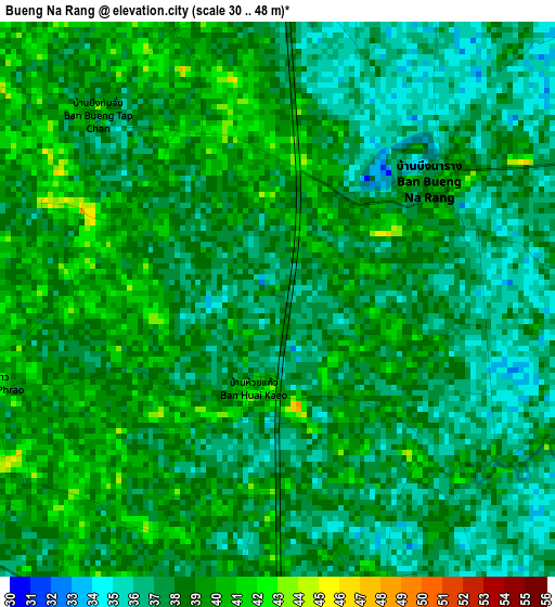
Below is the Elevation map of Bueng Na Rang, which displays elevation range with different colors. Scale of the first map is from 30 to 48 m (98 to 157 ft) with average elevation of 37.8 meters (=124 ft) [note 1]
These maps also provides idea of topography and contour of this city, they are displayed at different zoom levels. More info about maps, scale and edge coordinates you can find below images.
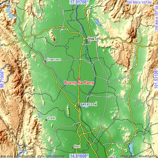
| \ | Map #1 | Map #2 | Topo.Map |
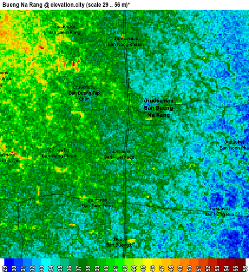
| Scale [m] | 30..48 m | 29..56 m | × |
| Scale [ft] | 98..157 ft | 95..184 ft | × |
| Average | 37.8 m = 124 ft | 37.4 m = 123 ft | × |
| Width | 9.39 km = 5.8 mi | 18.77 km = 11.7 mi | 300.3 km = 186.6 mi |
| Height | 9.39 km = 5.8 mi | 18.77 km = 11.7 mi | 300.3 km = 186.6 mi |
| ↑Max Latitude | 16.213402° | 16.255595° | 17.51708° |
| Latitude at center | 16.1712° | 16.1712° | 16.1712° |
| ↓Min Latitude | 16.128989° | 16.086769° | 14.81609° |
| ← Min Longitude | 100.081365° | 100.037419° | 98.71906° |
| Longitude center | 100.12531° | 100.12531° | 100.12531° |
| →Max Longitude | 100.169255° | 100.213201° | 101.53156° |
Nearby cities:
Cities around Bueng Na Rang sort by population:
• Phichit elevation 44 m
38.4 km,  38°
38°
• Taphan Hin 36 m
31.9 km,  80°
80°
• Khanu Woralaksaburi 52 m
30.8 km,  246°
246°
• Bang Mun Nak 33 m
31.5 km,  120°
120°
• Kao Liao 36 m
36 km,  187°
187°
• Wachira Barami 40 m
39.2 km,  3°
3°
• Sam Ngam 44 m
38.2 km,  12°
12°
• Chumsaeng 32 m
36.7 km,  147°
147°
• Thung Sai 57 m
35.1 km,  297°
297°
• Banphot Phisai 46 m
30.4 km,  210°
210°
• Pho Thale 35 m
16.9 km, 121°
• Bueng Samakkhi 49 m
16.1 km,  276°
276°
Multilingual:
 En español:
Bueng Na Rang elevación 37 m.
 En France:
Bueng Na Rang élévation 37 m.
 Auf Deutsch:
Bueng Na Rang höhe über dem Meeresspiegel ist 37 m.

Sources and notes:
- [note 1] Map square and city borders are not equal. Map elevation data is calculated only from area inside that square.
- [src 1] Elevation data from geonames database provided with same terms of usage.
- [src 2] The elevation map of Bueng Na Rang is generated using elevation data from NASA's 3 arcsec (90m) resolution SRTM data.
- [src 3] Base (background) map © OpenStreetMap contributors tiles are generated by Geofabrik and OpenTopoMap.
Copyright & License:
This Bueng Na Rang Elevation Map is licensed under CC BY-SA. You may reuse any part from this page, if you give a proper credit by linking to this URL:
 More info on terms of use page.