Kao Liao elevation
Kao Liao (Nakhon Sawan), Thailand elevation is 36 meters and Kao Liao elevation in feet is 118 ft above sea level [src 1]. Kao Liao is a seat of a second-order administrative division (feature code) with elevation that is 89 meters (292 ft) smaller than average city elevation in Thailand.
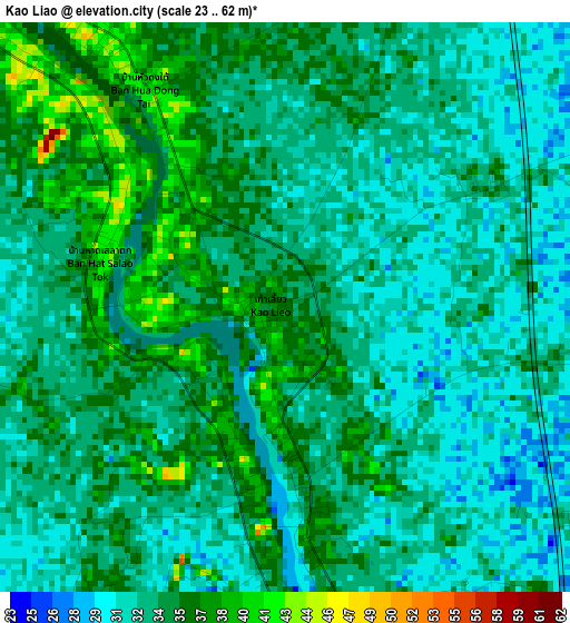
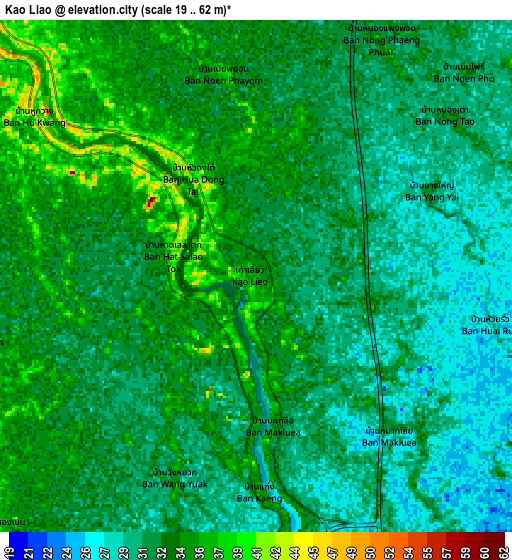
Below is the Elevation map of Kao Liao, which displays elevation range with different colors. Scale of the first map is from 23 to 62 m (75 to 203 ft) with average elevation of 33.2 meters (=109 ft) [note 1]
These maps also provides idea of topography and contour of this city, they are displayed at different zoom levels. More info about maps, scale and edge coordinates you can find below images.
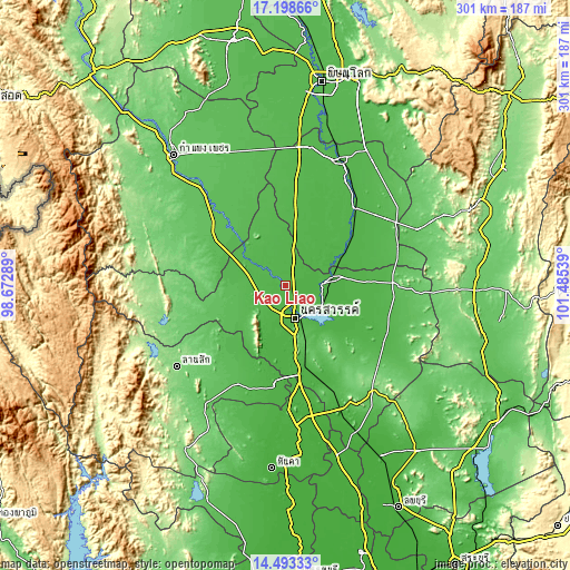
| \ | Map #1 | Map #2 | Topo.Map |
| Scale [m] | 23..62 m | 19..62 m | × |
| Scale [ft] | 75..203 ft | 62..203 ft | × |
| Average | 33.2 m = 109 ft | 32 m = 105 ft | × |
| Width | 9.4 km = 5.8 mi | 18.8 km = 11.7 mi | 300.8 km = 186.9 mi |
| Height | 9.4 km = 5.8 mi | 18.8 km = 11.7 mi | 300.8 km = 186.9 mi |
| ↑Max Latitude | 15.8928° | 15.935061° | 17.19866° |
| Latitude at center | 15.85053° | 15.85053° | 15.85053° |
| ↓Min Latitude | 15.808251° | 15.765964° | 14.49333° |
| ← Min Longitude | 100.035195° | 99.991249° | 98.67289° |
| Longitude center | 100.07914° | 100.07914° | 100.07914° |
| →Max Longitude | 100.123085° | 100.167031° | 101.48539° |
Nearby cities:
Cities around Kao Liao sort by population:
• Nakhon Sawan elevation 31 m
17.4 km,  159°
159°
• Khanu Woralaksaburi 52 m
33.1 km,  315°
315°
• Lat Yao 62 m
32.9 km,  250°
250°
• Bang Mun Nak 33 m
37.7 km,  58°
58°
• Phayuha Khiri 27 m
44.4 km,  172°
172°
• Bueng Na Rang 37 m
36 km,  7°
7°
• Bueng Samakkhi 49 m
39.1 km,  343°
343°
• Sawang Arom 44 m
37.7 km,  218°
218°
• Pho Thale 35 m
33.2 km,  35°
35°
• Krok Phra 26 m
32.8 km,  181°
181°
• Chumsaeng 32 m
24.9 km,  79°
79°
• Banphot Phisai 46 m
14.1 km,  312°
312°
Multilingual:
 En español:
Kao Liao elevación 36 m.
 En France:
Kao Liao élévation 36 m.


Sources and notes:
- [note 1] Map square and city borders are not equal. Map elevation data is calculated only from area inside that square.
- [src 1] Elevation data from geonames database provided with same terms of usage.
- [src 2] The elevation map of Kao Liao is generated using elevation data from NASA's 3 arcsec (90m) resolution SRTM data.
- [src 3] Base (background) map © OpenStreetMap contributors tiles are generated by Geofabrik and OpenTopoMap.
Copyright & License:
This Kao Liao Elevation Map is licensed under CC BY-SA. You may reuse any part from this page, if you give a proper credit by linking to this URL:
 More info on terms of use page.