Yelabuga elevation
Yelabuga (Tatarstan Republic), Russia elevation is 72 meters and Yelabuga elevation in feet is 236 ft above sea level [src 1]. Yelabuga is a populated place (feature code) with elevation that is 127 meters (417 ft) smaller than average city elevation in Russia.
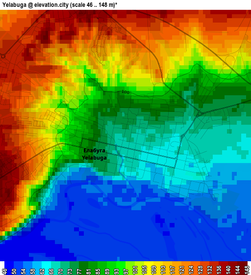
Below is the Elevation map of Yelabuga, which displays elevation range with different colors. Scale of the first map is from 46 to 148 m (151 to 486 ft) with average elevation of 87.4 meters (=287 ft) [note 1]
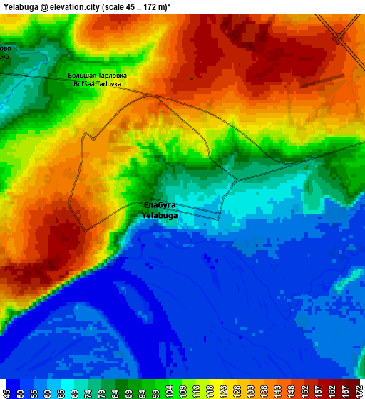
These maps also provides idea of topography and contour of this city, they are displayed at different zoom levels. More info about maps, scale and edge coordinates you can find below images.
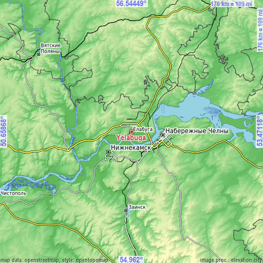
| \ | Map #1 | Map #2 | Topo.Map |
| Scale [m] | 46..148 m | 45..172 m | × |
| Scale [ft] | 151..486 ft | 148..564 ft | × |
| Average | 87.4 m = 287 ft | 95.3 m = 313 ft | × |
| Width | 5.5 km = 3.4 mi | 11 km = 6.8 mi | 176 km = 109.4 mi |
| Height | 5.5 km = 3.4 mi | 11 km = 6.8 mi | 175.9 km = 109.3 mi |
| ↑Max Latitude | 55.785988° | 55.81069° | 56.54449° |
| Latitude at center | 55.76127° | 55.76127° | 55.76127° |
| ↓Min Latitude | 55.736537° | 55.711788° | 54.962° |
| ← Min Longitude | 52.020985° | 51.977039° | 50.65868° |
| Longitude center | 52.06493° | 52.06493° | 52.06493° |
| →Max Longitude | 52.108875° | 52.152821° | 53.47118° |
Nearby cities:
Cities around Yelabuga sort by population:
• Naberezhnyye Chelny elevation 103 m
22 km,  100°
100°
• Nizhnekamsk 119 m
20.5 km,  227°
227°
• Zainsk 109 m
49.1 km,  179°
179°
• Mendeleyevsk 101 m
21.6 km,  40°
40°
• Menzelinsk 98 m
65.1 km,  93°
93°
• Mamadysh 90 m
41.4 km,  262°
262°
• Sosnovka 91 m
73.3 km,  318°
318°
• Kizner 76 m
66.8 km,  328°
328°
• Sarmanovo 130 m
65.2 km,  149°
149°
• Alnashi 120 m
53.9 km,  28°
28°
• Grakhovo 124 m
32.7 km,  349°
349°
• Lubyany 60 m
51.6 km,  306°
306°
Multilingual:
 En español:
Yelabuga elevación 72 m.
 En France:
Yelabuga élévation 72 m.


Sources and notes:
- [note 1] Map square and city borders are not equal. Map elevation data is calculated only from area inside that square.
- [src 1] Elevation data from geonames database provided with same terms of usage.
- [src 2] The elevation map of Yelabuga is generated using elevation data from NASA's 3 arcsec (90m) resolution SRTM data.
- [src 3] Base (background) map © OpenStreetMap contributors tiles are generated by Geofabrik and OpenTopoMap.
Copyright & License:
This Yelabuga Elevation Map is licensed under CC BY-SA. You may reuse any part from this page, if you give a proper credit by linking to this URL:
 More info on terms of use page.