Kizner elevation
Kizner (Udmurtiya Republic), Russia elevation is 76 meters and Kizner elevation in feet is 249 ft above sea level [src 1]. Kizner is a populated place (feature code) with elevation that is 123 meters (404 ft) smaller than average city elevation in Russia.
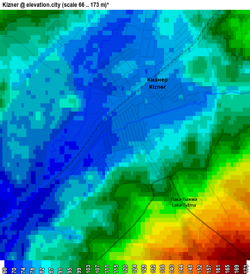
Below is the Elevation map of Kizner, which displays elevation range with different colors. Scale of the first map is from 66 to 173 m (217 to 568 ft) with average elevation of 92 meters (=302 ft) [note 1]
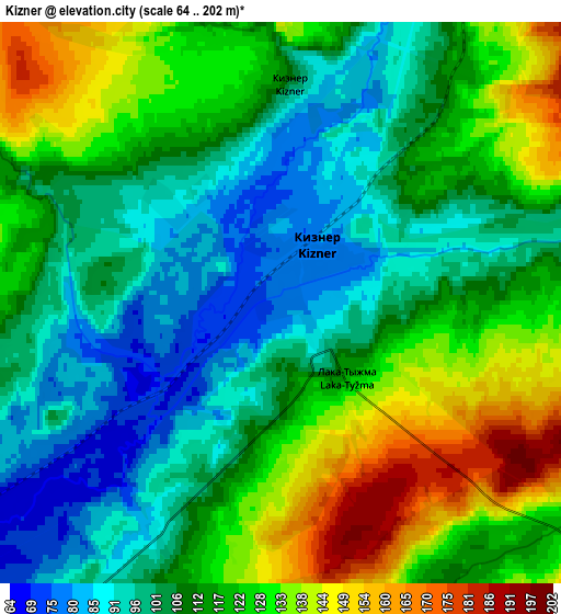
These maps also provides idea of topography and contour of this city, they are displayed at different zoom levels. More info about maps, scale and edge coordinates you can find below images.
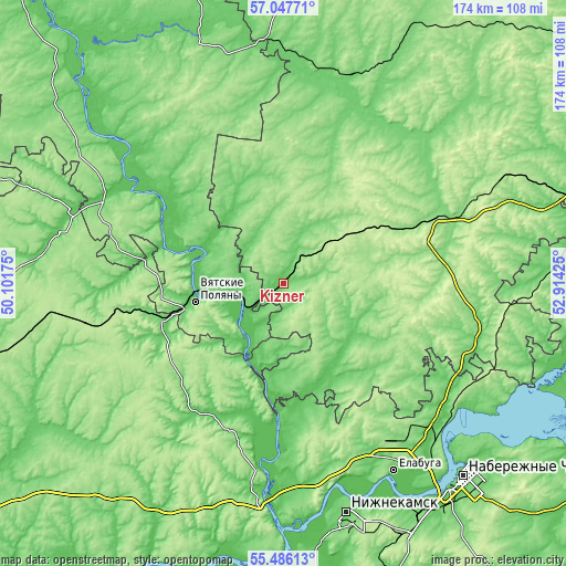
| \ | Map #1 | Map #2 | Topo.Map |
| Scale [m] | 66..173 m | 64..202 m | × |
| Scale [ft] | 217..568 ft | 210..663 ft | × |
| Average | 92 m = 302 ft | 113.7 m = 373 ft | × |
| Width | 5.43 km = 3.4 mi | 10.85 km = 6.7 mi | 173.6 km = 107.9 mi |
| Height | 5.43 km = 3.4 mi | 10.85 km = 6.7 mi | 173.6 km = 107.9 mi |
| ↑Max Latitude | 56.299281° | 56.323657° | 57.04771° |
| Latitude at center | 56.27489° | 56.27489° | 56.27489° |
| ↓Min Latitude | 56.250483° | 56.226061° | 55.48613° |
| ← Min Longitude | 51.464055° | 51.420109° | 50.10175° |
| Longitude center | 51.508° | 51.508° | 51.508° |
| →Max Longitude | 51.551945° | 51.595891° | 52.91425° |
Nearby cities:
Cities around Kizner sort by population:
• Mozhga elevation 152 m
48.2 km,  66°
66°
• Vyatskiye Polyany 74 m
27.9 km,  258°
258°
• Kukmor 102 m
39.2 km, 255°
• Mamadysh 90 m
62.5 km,  185°
185°
• Sosnovka 91 m
14 km, 260°
• Malmyzh 76 m
57.7 km,  298°
298°
• Krasnaya Polyana 65 m
22.8 km, 260°
• Alnashi 120 m
60.8 km,  99°
99°
• Vavozh 137 m
61.4 km,  25°
25°
• Grakhovo 124 m
37.9 km,  131°
131°
• Pychas 154 m
62.8 km, 66°
• Lubyany 60 m
27.2 km, 194°
Multilingual:
 En español:
Kizner elevación 76 m.
 En France:
Kizner élévation 76 m.


Sources and notes:
- [note 1] Map square and city borders are not equal. Map elevation data is calculated only from area inside that square.
- [src 1] Elevation data from geonames database provided with same terms of usage.
- [src 2] The elevation map of Kizner is generated using elevation data from NASA's 3 arcsec (90m) resolution SRTM data.
- [src 3] Base (background) map © OpenStreetMap contributors tiles are generated by Geofabrik and OpenTopoMap.
Copyright & License:
This Kizner Elevation Map is licensed under CC BY-SA. You may reuse any part from this page, if you give a proper credit by linking to this URL:
 More info on terms of use page.