Mamadysh elevation
Mamadysh (Tatarstan Republic), Russia elevation is 90 meters and Mamadysh elevation in feet is 295 ft above sea level [src 1]. Mamadysh is a populated place (feature code) with elevation that is 109 meters (358 ft) smaller than average city elevation in Russia.
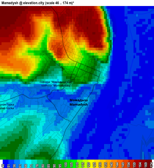
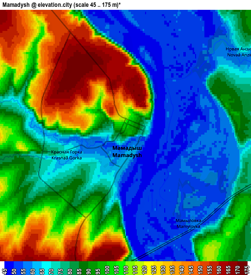
Below is the Elevation map of Mamadysh, which displays elevation range with different colors. Scale of the first map is from 46 to 174 m (151 to 571 ft) with average elevation of 83.7 meters (=275 ft) [note 1]
These maps also provides idea of topography and contour of this city, they are displayed at different zoom levels. More info about maps, scale and edge coordinates you can find below images.
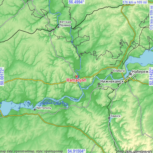
| \ | Map #1 | Map #2 | Topo.Map |
| Scale [m] | 46..174 m | 45..175 m | × |
| Scale [ft] | 151..571 ft | 148..574 ft | × |
| Average | 83.7 m = 275 ft | 89.1 m = 292 ft | × |
| Width | 5.5 km = 3.4 mi | 11.01 km = 6.8 mi | 176.2 km = 109.5 mi |
| Height | 5.5 km = 3.4 mi | 11.01 km = 6.8 mi | 176.1 km = 109.4 mi |
| ↑Max Latitude | 55.739997° | 55.764728° | 56.4994° |
| Latitude at center | 55.71525° | 55.71525° | 55.71525° |
| ↓Min Latitude | 55.690487° | 55.665709° | 54.91504° |
| ← Min Longitude | 51.364025° | 51.320079° | 50.00172° |
| Longitude center | 51.40797° | 51.40797° | 51.40797° |
| →Max Longitude | 51.451915° | 51.495861° | 52.81422° |
Nearby cities:
Cities around Mamadysh sort by population:
• Nizhnekamsk elevation 119 m
27.5 km,  108°
108°
• Yelabuga 72 m
41.4 km,  82°
82°
• Chistopol’ 107 m
62.1 km,  230°
230°
• Zainsk 109 m
60.6 km,  136°
136°
• Vyatskiye Polyany 74 m
60.7 km,  339°
339°
• Mendeleyevsk 101 m
59.2 km,  68°
68°
• Kukmor 102 m
61.3 km,  328°
328°
• Sosnovka 91 m
60.5 km,  352°
352°
• Kizner 76 m
62.5 km,  5°
5°
• Krasnaya Polyana 65 m
60.8 km, 344°
• Grakhovo 124 m
51 km,  43°
43°
• Lubyany 60 m
35.9 km,  359°
359°
Multilingual:
 En español:
Mamadysh elevación 90 m.
 En France:
Mamadych élévation 90 m.
 Auf Deutsch:
Mamadysch höhe über dem Meeresspiegel ist 90 m.

Sources and notes:
- [note 1] Map square and city borders are not equal. Map elevation data is calculated only from area inside that square.
- [src 1] Elevation data from geonames database provided with same terms of usage.
- [src 2] The elevation map of Mamadysh is generated using elevation data from NASA's 3 arcsec (90m) resolution SRTM data.
- [src 3] Base (background) map © OpenStreetMap contributors tiles are generated by Geofabrik and OpenTopoMap.
Copyright & License:
This Mamadysh Elevation Map is licensed under CC BY-SA. You may reuse any part from this page, if you give a proper credit by linking to this URL:
 More info on terms of use page.