Zainsk elevation
Zainsk (Tatarstan Republic), Russia elevation is 109 meters and Zainsk elevation in feet is 358 ft above sea level [src 1]. Zainsk is a populated place (feature code) with elevation that is 90 meters (295 ft) smaller than average city elevation in Russia.
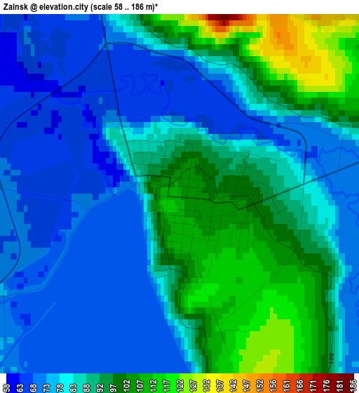
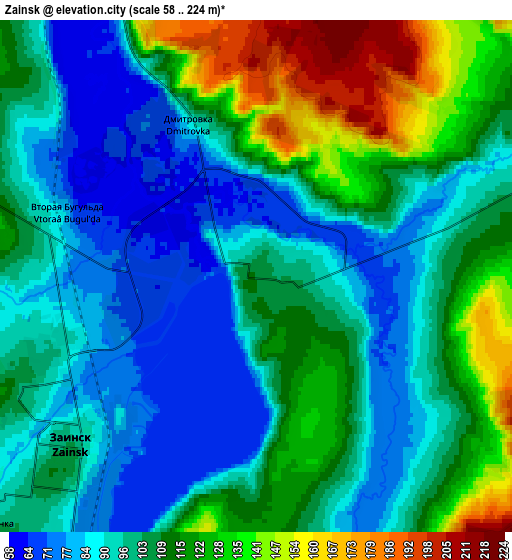
Below is the Elevation map of Zainsk, which displays elevation range with different colors. Scale of the first map is from 58 to 186 m (190 to 610 ft) with average elevation of 85.5 meters (=281 ft) [note 1]
These maps also provides idea of topography and contour of this city, they are displayed at different zoom levels. More info about maps, scale and edge coordinates you can find below images.
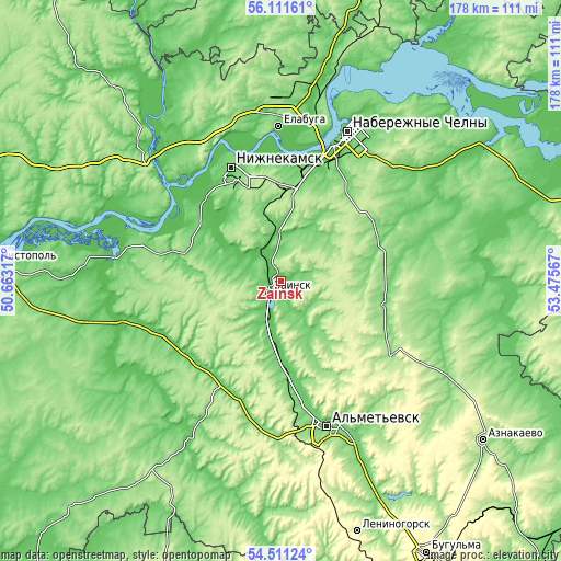
| \ | Map #1 | Map #2 | Topo.Map |
| Scale [m] | 58..186 m | 58..224 m | × |
| Scale [ft] | 190..610 ft | 190..735 ft | × |
| Average | 85.5 m = 281 ft | 104.7 m = 344 ft | × |
| Width | 5.56 km = 3.5 mi | 11.12 km = 6.9 mi | 177.9 km = 110.5 mi |
| Height | 5.56 km = 3.5 mi | 11.12 km = 6.9 mi | 177.9 km = 110.5 mi |
| ↑Max Latitude | 55.344497° | 55.369478° | 56.11161° |
| Latitude at center | 55.3195° | 55.3195° | 55.3195° |
| ↓Min Latitude | 55.294487° | 55.269459° | 54.51124° |
| ← Min Longitude | 52.025475° | 51.981529° | 50.66317° |
| Longitude center | 52.06942° | 52.06942° | 52.06942° |
| →Max Longitude | 52.113365° | 52.157311° | 53.47567° |
Nearby cities:
Cities around Zainsk sort by population:
• Naberezhnyye Chelny elevation 103 m
50 km,  25°
25°
• Nizhnekamsk 119 m
38.5 km,  336°
336°
• Al’met’yevsk 121 m
48.7 km,  161°
161°
• Yelabuga 72 m
49.1 km,  359°
359°
• Mendeleyevsk 101 m
66.9 km,  11°
11°
• Dzhalil’ 288 m
53.6 km,  127°
127°
• Mamadysh 90 m
60.6 km,  316°
316°
• Nizhnyaya Maktama 110 m
55.6 km, 155°
• Muslyumovo 77 m
71.2 km,  91°
91°
• Sarmanovo 130 m
33.7 km,  102°
102°
• Novosheshminsk 63 m
60.1 km,  241°
241°
• Russkiy Aktash 88 m
31.4 km,  173°
173°
Multilingual:
 En español:
Zaínsk elevación 109 m.
 En France:
Zaïnsk élévation 109 m.


Sources and notes:
- [note 1] Map square and city borders are not equal. Map elevation data is calculated only from area inside that square.
- [src 1] Elevation data from geonames database provided with same terms of usage.
- [src 2] The elevation map of Zainsk is generated using elevation data from NASA's 3 arcsec (90m) resolution SRTM data.
- [src 3] Base (background) map © OpenStreetMap contributors tiles are generated by Geofabrik and OpenTopoMap.
Copyright & License:
This Zainsk Elevation Map is licensed under CC BY-SA. You may reuse any part from this page, if you give a proper credit by linking to this URL:
 More info on terms of use page.