Chistopol’ elevation
Chistopol’ (Tatarstan Republic, Chistopol’skiy Rayon), Russia elevation is 107 meters and Chistopol’ elevation in feet is 351 ft above sea level [src 1]. Chistopol’ is a populated place (feature code) with elevation that is 92 meters (302 ft) smaller than average city elevation in Russia.
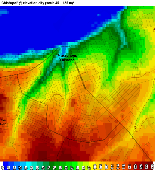
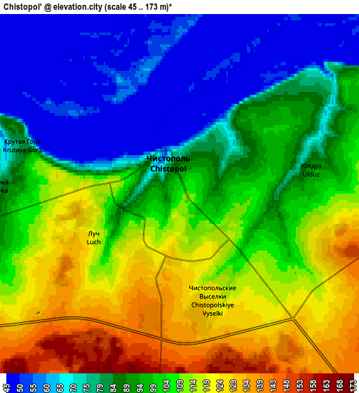
Below is the Elevation map of Chistopol’, which displays elevation range with different colors. Scale of the first map is from 45 to 135 m (148 to 443 ft) with average elevation of 92.3 meters (=303 ft) [note 1]
These maps also provides idea of topography and contour of this city, they are displayed at different zoom levels. More info about maps, scale and edge coordinates you can find below images.
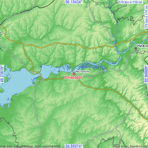
| \ | Map #1 | Map #2 | Topo.Map |
| Scale [m] | 45..135 m | 45..173 m | × |
| Scale [ft] | 148..443 ft | 148..568 ft | × |
| Average | 92.3 m = 303 ft | 94.9 m = 311 ft | × |
| Width | 5.55 km = 3.4 mi | 11.11 km = 6.9 mi | 177.7 km = 110.4 mi |
| Height | 5.55 km = 3.4 mi | 11.11 km = 6.9 mi | 177.7 km = 110.4 mi |
| ↑Max Latitude | 55.388079° | 55.413033° | 56.15434° |
| Latitude at center | 55.36311° | 55.36311° | 55.36311° |
| ↓Min Latitude | 55.338125° | 55.313124° | 54.55574° |
| ← Min Longitude | 50.598495° | 50.554549° | 49.23619° |
| Longitude center | 50.64244° | 50.64244° | 50.64244° |
| →Max Longitude | 50.686385° | 50.730331° | 52.04869° |
Nearby cities:
Cities around Chistopol’ sort by population:
• Nizhnekamsk elevation 119 m
80.4 km,  67°
67°
• Mamadysh 90 m
62.1 km,  50°
50°
• Alekseyevskoye 56 m
34 km,  259°
259°
• Laishevo 101 m
69.1 km,  273°
273°
• Pestretsy 98 m
75.8 km,  304°
304°
• Bogatyye Saby 152 m
73 km,  350°
350°
• Rybnaya Sloboda 115 m
33.5 km,  289°
289°
• Bazarnyye Mataki 130 m
69.8 km,  220°
220°
• Novosheshminsk 63 m
50 km,  131°
131°
• Tyulyachi 99 m
63.9 km,  336°
336°
• Bilyarsk 107 m
45.2 km,  201°
201°
• Lubyany 60 m
88.8 km,  32°
32°
Multilingual:
 En español:
Chistopol’ elevación 107 m.
 En France:
Chistopol’ élévation 107 m.
 Auf Deutsch:
Chistopol’ höhe über dem Meeresspiegel ist 107 m.

Sources and notes:
- [note 1] Map square and city borders are not equal. Map elevation data is calculated only from area inside that square.
- [src 1] Elevation data from geonames database provided with same terms of usage.
- [src 2] The elevation map of Chistopol’ is generated using elevation data from NASA's 3 arcsec (90m) resolution SRTM data.
- [src 3] Base (background) map © OpenStreetMap contributors tiles are generated by Geofabrik and OpenTopoMap.
Copyright & License:
This Chistopol’ Elevation Map is licensed under CC BY-SA. You may reuse any part from this page, if you give a proper credit by linking to this URL:
 More info on terms of use page.