Alnashi elevation
Alnashi (Udmurtiya Republic), Russia elevation is 120 meters and Alnashi elevation in feet is 394 ft above sea level [src 1]. Alnashi is a populated place (feature code) with elevation that is 79 meters (259 ft) smaller than average city elevation in Russia.
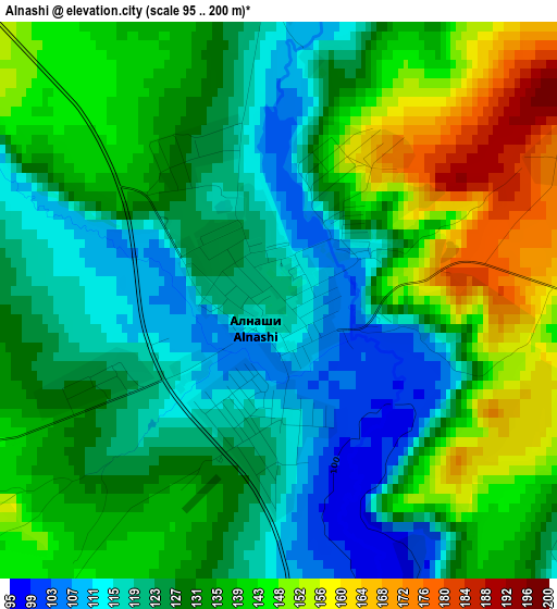
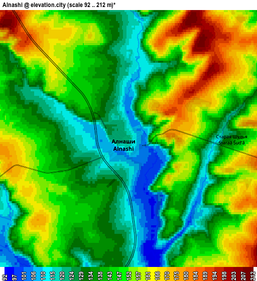
Below is the Elevation map of Alnashi, which displays elevation range with different colors. Scale of the first map is from 95 to 200 m (312 to 656 ft) with average elevation of 132.4 meters (=434 ft) [note 1]
These maps also provides idea of topography and contour of this city, they are displayed at different zoom levels. More info about maps, scale and edge coordinates you can find below images.
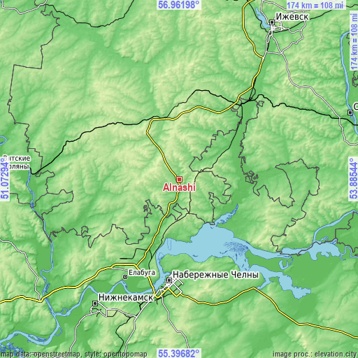
| \ | Map #1 | Map #2 | Topo.Map |
| Scale [m] | 95..200 m | 92..212 m | × |
| Scale [ft] | 312..656 ft | 302..696 ft | × |
| Average | 132.4 m = 434 ft | 144.1 m = 473 ft | × |
| Width | 5.44 km = 3.4 mi | 10.88 km = 6.8 mi | 174 km = 108.1 mi |
| Height | 5.44 km = 3.4 mi | 10.88 km = 6.8 mi | 174 km = 108.1 mi |
| ↑Max Latitude | 56.211827° | 56.236258° | 56.96198° |
| Latitude at center | 56.18738° | 56.18738° | 56.18738° |
| ↓Min Latitude | 56.162918° | 56.13844° | 55.39682° |
| ← Min Longitude | 52.435245° | 52.391299° | 51.07294° |
| Longitude center | 52.47919° | 52.47919° | 52.47919° |
| →Max Longitude | 52.523135° | 52.567081° | 53.88544° |
Nearby cities:
Cities around Alnashi sort by population:
• Naberezhnyye Chelny elevation 103 m
51.5 km,  184°
184°
• Yelabuga 72 m
53.9 km,  208°
208°
• Mozhga 152 m
32.5 km,  331°
331°
• Mendeleyevsk 101 m
33.2 km,  200°
200°
• Agryz 93 m
48.8 km,  40°
40°
• Menzelinsk 98 m
64.2 km,  142°
142°
• Kizner 76 m
60.8 km,  279°
279°
• Malaya Purga 114 m
52.3 km, 38°
• Grakhovo 124 m
35.2 km,  244°
244°
• Kiyasovo 168 m
43.7 km,  65°
65°
• Pychas 154 m
35.2 km,  356°
356°
• Lubyany 60 m
68.9 km,  256°
256°
Multilingual:
 En español:
Alnashi elevación 120 m.
 En France:
Alnashi élévation 120 m.


Sources and notes:
- [note 1] Map square and city borders are not equal. Map elevation data is calculated only from area inside that square.
- [src 1] Elevation data from geonames database provided with same terms of usage.
- [src 2] The elevation map of Alnashi is generated using elevation data from NASA's 3 arcsec (90m) resolution SRTM data.
- [src 3] Base (background) map © OpenStreetMap contributors tiles are generated by Geofabrik and OpenTopoMap.
Copyright & License:
This Alnashi Elevation Map is licensed under CC BY-SA. You may reuse any part from this page, if you give a proper credit by linking to this URL:
 More info on terms of use page.