Menzelinsk elevation
Menzelinsk (Tatarstan Republic), Russia elevation is 98 meters and Menzelinsk elevation in feet is 322 ft above sea level [src 1]. Menzelinsk is a populated place (feature code) with elevation that is 101 meters (331 ft) smaller than average city elevation in Russia.
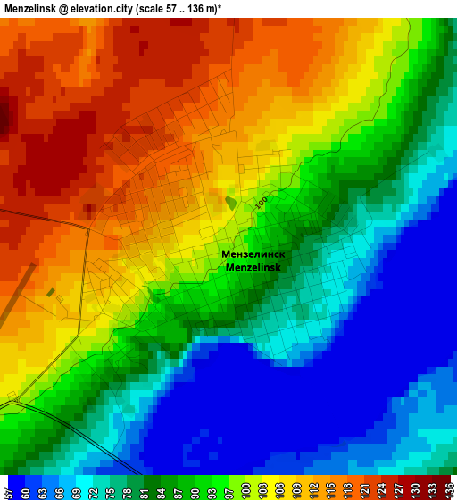
Below is the Elevation map of Menzelinsk, which displays elevation range with different colors. Scale of the first map is from 57 to 136 m (187 to 446 ft) with average elevation of 92 meters (=302 ft) [note 1]
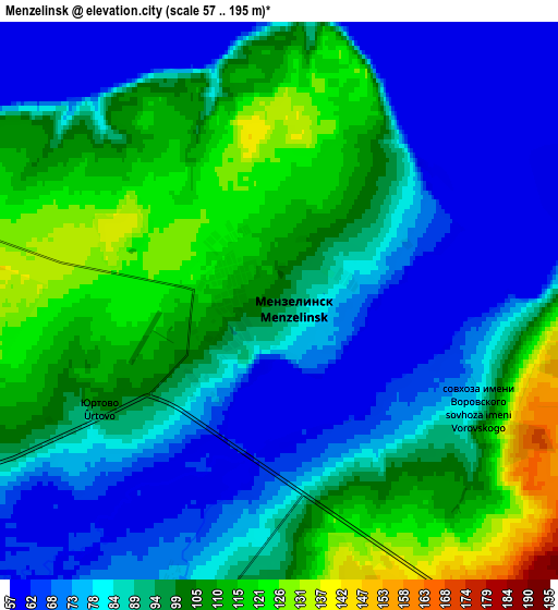
These maps also provides idea of topography and contour of this city, they are displayed at different zoom levels. More info about maps, scale and edge coordinates you can find below images.
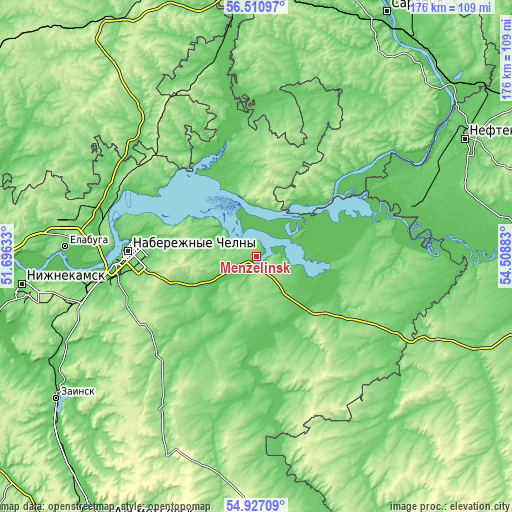
| \ | Map #1 | Map #2 | Topo.Map |
| Scale [m] | 57..136 m | 57..195 m | × |
| Scale [ft] | 187..446 ft | 187..640 ft | × |
| Average | 92 m = 302 ft | 91.8 m = 301 ft | × |
| Width | 5.5 km = 3.4 mi | 11.01 km = 6.8 mi | 176.1 km = 109.4 mi |
| Height | 5.5 km = 3.4 mi | 11.01 km = 6.8 mi | 176.1 km = 109.4 mi |
| ↑Max Latitude | 55.751799° | 55.776523° | 56.51097° |
| Latitude at center | 55.72706° | 55.72706° | 55.72706° |
| ↓Min Latitude | 55.702305° | 55.677534° | 54.92709° |
| ← Min Longitude | 53.058635° | 53.014689° | 51.69633° |
| Longitude center | 53.10258° | 53.10258° | 53.10258° |
| →Max Longitude | 53.146525° | 53.190471° | 54.50883° |
Nearby cities:
Cities around Menzelinsk sort by population:
• Naberezhnyye Chelny elevation 103 m
43.3 km,  269°
269°
• Yelabuga 72 m
65.1 km, 273°
• Mendeleyevsk 101 m
54.6 km,  291°
291°
• Agidel’ 82 m
55.8 km,  68°
68°
• Bakaly 108 m
75.3 km,  144°
144°
• Aktanysh 67 m
61.4 km,  90°
90°
• Muslyumovo 77 m
47.5 km,  172°
172°
• Sarmanovo 130 m
61.6 km,  211°
211°
• Alnashi 120 m
64.2 km,  322°
322°
• Nikolo-Berëzovka 70 m
79.1 km,  56°
56°
• Karakulino 112 m
49.2 km,  49°
49°
• Kiyasovo 168 m
69.2 km,  1°
1°
Multilingual:
 En español:
Menzelinsk elevación 98 m.
 En France:
Menzelinsk élévation 98 m.
 Auf Deutsch:
Menselinsk höhe über dem Meeresspiegel ist 98 m.

Sources and notes:
- [note 1] Map square and city borders are not equal. Map elevation data is calculated only from area inside that square.
- [src 1] Elevation data from geonames database provided with same terms of usage.
- [src 2] The elevation map of Menzelinsk is generated using elevation data from NASA's 3 arcsec (90m) resolution SRTM data.
- [src 3] Base (background) map © OpenStreetMap contributors tiles are generated by Geofabrik and OpenTopoMap.
Copyright & License:
This Menzelinsk Elevation Map is licensed under CC BY-SA. You may reuse any part from this page, if you give a proper credit by linking to this URL:
 More info on terms of use page.