Gujar Khan elevation
Gujar Khan (Punjab), Pakistan elevation is 461 meters and Gujar Khan elevation in feet is 1512 ft above sea level [src 1]. Gujar Khan is a populated place (feature code) with elevation that is 115 meters (377 ft) bigger than average city elevation in Pakistan.
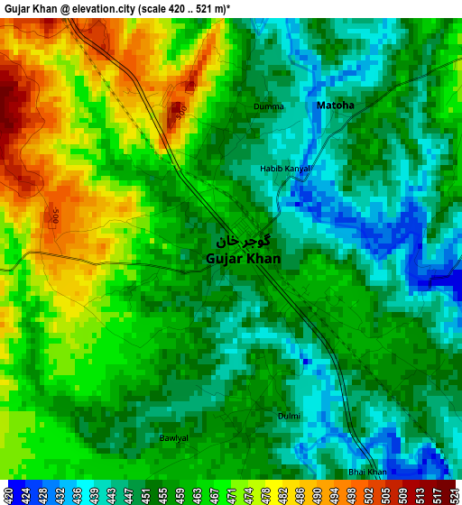
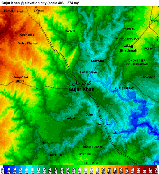
Below is the Elevation map of Gujar Khan, which displays elevation range with different colors. Scale of the first map is from 420 to 521 m (1378 to 1709 ft) with average elevation of 459.5 meters (=1508 ft) [note 1]
These maps also provides idea of topography and contour of this city, they are displayed at different zoom levels. More info about maps, scale and edge coordinates you can find below images.
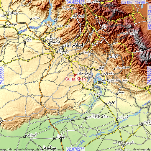
| \ | Map #1 | Map #2 | Topo.Map |
| Scale [m] | 420..521 m | 403..574 m | × |
| Scale [ft] | 1378..1709 ft | 1322..1883 ft | × |
| Average | 459.5 m = 1508 ft | 472.9 m = 1552 ft | × |
| Width | 8.17 km = 5.1 mi | 16.34 km = 10.2 mi | 261.5 km = 162.5 mi |
| Height | 8.17 km = 5.1 mi | 16.34 km = 10.2 mi | 261.5 km = 162.5 mi |
| ↑Max Latitude | 33.290851° | 33.327577° | 34.42212° |
| Latitude at center | 33.25411° | 33.25411° | 33.25411° |
| ↓Min Latitude | 33.217353° | 33.180581° | 32.07027° |
| ← Min Longitude | 73.260385° | 73.216439° | 71.89808° |
| Longitude center | 73.30433° | 73.30433° | 73.30433° |
| →Max Longitude | 73.348275° | 73.392221° | 74.71058° |
Nearby cities:
Cities around Gujar Khan sort by population:
• Rawalpindi elevation 499 m
45 km,  328°
328°
• Kotli 609 m
62.8 km,  62°
62°
• Islamabad 579 m
57.3 km,  335°
335°
• Jhelum 230 m
53.3 km,  131°
131°
• Chakwal 523 m
55.1 km,  229°
229°
• Sarai Alamgir 232 m
57.2 km, 132°
• Kamra 1006 m
58.1 km,  19°
19°
• Kahuta 610 m
38.3 km,  11°
11°
• Choa Saidan Shah 625 m
66.4 km,  206°
206°
• Daultala 547 m
16.7 km,  245°
245°
• Nazir Town 495 m
17.6 km,  70°
70°
• New Mirpur 436 m
43.3 km,  105°
105°
Multilingual:
 En español:
Gujar Khan elevación 461 m.
 En France:
Gujar Khan élévation 461 m.
 Auf Deutsch:
Gujar Khan höhe über dem Meeresspiegel ist 461 m.

Sources and notes:
- [note 1] Map square and city borders are not equal. Map elevation data is calculated only from area inside that square.
- [src 1] Elevation data from geonames database provided with same terms of usage.
- [src 2] The elevation map of Gujar Khan is generated using elevation data from NASA's 3 arcsec (90m) resolution SRTM data.
- [src 3] Base (background) map © OpenStreetMap contributors tiles are generated by Geofabrik and OpenTopoMap.
Copyright & License:
This Gujar Khan Elevation Map is licensed under CC BY-SA. You may reuse any part from this page, if you give a proper credit by linking to this URL:
 More info on terms of use page.