Jhelum elevation
Jhelum (Punjab), Pakistan elevation is 230 meters and Jhelum elevation in feet is 755 ft above sea level [src 1]. Jhelum is a seat of a second-order administrative division (feature code) with elevation that is 116 meters (381 ft) smaller than average city elevation in Pakistan.
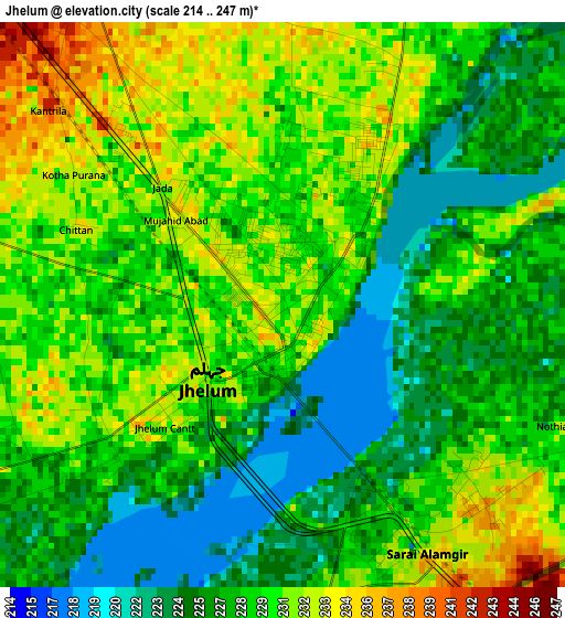
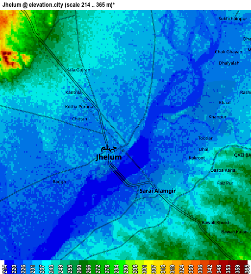
Below is the Elevation map of Jhelum, which displays elevation range with different colors. Scale of the first map is from 214 to 247 m (702 to 810 ft) with average elevation of 228.5 meters (=750 ft) [note 1]
These maps also provides idea of topography and contour of this city, they are displayed at different zoom levels. More info about maps, scale and edge coordinates you can find below images.
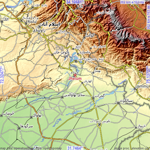
| \ | Map #1 | Map #2 | Topo.Map |
| Scale [m] | 214..247 m | 214..365 m | × |
| Scale [ft] | 702..810 ft | 702..1198 ft | × |
| Average | 228.5 m = 750 ft | 237.1 m = 778 ft | × |
| Width | 8.2 km = 5.1 mi | 16.4 km = 10.2 mi | 262.5 km = 163.1 mi |
| Height | 8.2 km = 5.1 mi | 16.4 km = 10.2 mi | 262.5 km = 163.1 mi |
| ↑Max Latitude | 32.971355° | 33.008215° | 34.10681° |
| Latitude at center | 32.93448° | 32.93448° | 32.93448° |
| ↓Min Latitude | 32.897589° | 32.860683° | 31.7464° |
| ← Min Longitude | 73.687075° | 73.643129° | 72.32477° |
| Longitude center | 73.73102° | 73.73102° | 73.73102° |
| →Max Longitude | 73.774965° | 73.818911° | 75.13727° |
Nearby cities:
Cities around Jhelum sort by population:
• Bhimbar elevation 332 m
32.7 km,  82°
82°
• Gujrat 237 m
51.4 km,  141°
141°
• Mandi Bahauddin 223 m
44.7 km,  210°
210°
• Kharian 285 m
19.6 km,  132°
132°
• Gujar Khan 461 m
53.3 km,  311°
311°
• Lala Musa 258 m
33.5 km, 140°
• Sarai Alamgir 232 m
4 km,  145°
145°
• Dinga 229 m
32.6 km,  181°
181°
• Kunjah 234 m
50.4 km, 153°
• Nazir Town 495 m
47.3 km,  330°
330°
• Mehmand Chak 274 m
18.7 km, 152°
• New Mirpur 436 m
23.8 km,  4°
4°
Multilingual:
 En español:
Jhelum elevación 230 m.
 En France:
Jhelum élévation 230 m.


Sources and notes:
- [note 1] Map square and city borders are not equal. Map elevation data is calculated only from area inside that square.
- [src 1] Elevation data from geonames database provided with same terms of usage.
- [src 2] The elevation map of Jhelum is generated using elevation data from NASA's 3 arcsec (90m) resolution SRTM data.
- [src 3] Base (background) map © OpenStreetMap contributors tiles are generated by Geofabrik and OpenTopoMap.
Copyright & License:
This Jhelum Elevation Map is licensed under CC BY-SA. You may reuse any part from this page, if you give a proper credit by linking to this URL:
 More info on terms of use page.