Gujrat elevation
Gujrat (Punjab), Pakistan elevation is 237 meters and Gujrat elevation in feet is 778 ft above sea level [src 1]. Gujrat is a seat of a second-order administrative division (feature code) with elevation that is 109 meters (358 ft) smaller than average city elevation in Pakistan.
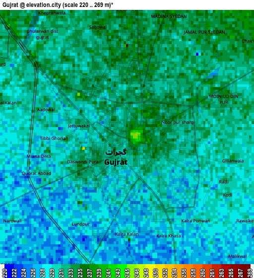
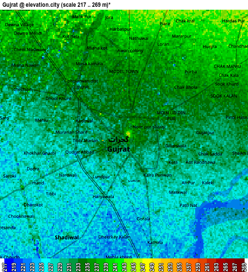
Below is the Elevation map of Gujrat, which displays elevation range with different colors. Scale of the first map is from 220 to 269 m (722 to 883 ft) with average elevation of 230.7 meters (=757 ft) [note 1]
These maps also provides idea of topography and contour of this city, they are displayed at different zoom levels. More info about maps, scale and edge coordinates you can find below images.
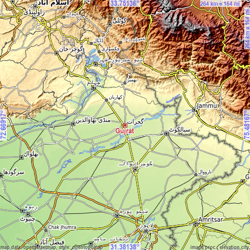
| \ | Map #1 | Map #2 | Topo.Map |
| Scale [m] | 220..269 m | 217..269 m | × |
| Scale [ft] | 722..883 ft | 712..883 ft | × |
| Average | 230.7 m = 757 ft | 231.1 m = 758 ft | × |
| Width | 8.24 km = 5.1 mi | 16.47 km = 10.2 mi | 263.5 km = 163.7 mi |
| Height | 8.24 km = 5.1 mi | 16.47 km = 10.2 mi | 263.5 km = 163.7 mi |
| ↑Max Latitude | 32.611225° | 32.648234° | 33.75136° |
| Latitude at center | 32.5742° | 32.5742° | 32.5742° |
| ↓Min Latitude | 32.53716° | 32.500104° | 31.38138° |
| ← Min Longitude | 74.031475° | 73.987529° | 72.66917° |
| Longitude center | 74.07542° | 74.07542° | 74.07542° |
| →Max Longitude | 74.119365° | 74.163311° | 75.48167° |
Nearby cities:
Cities around Gujrat sort by population:
• Wazirabad elevation 231 m
15.1 km,  163°
163°
• Jalalpur Jattan 250 m
14.3 km,  58°
58°
• Kharian 285 m
32.2 km,  326°
326°
• Lala Musa 258 m
17.9 km,  322°
322°
• Sambrial 239 m
28.2 km,  112°
112°
• Dinga 229 m
34.1 km,  282°
282°
• Kunjah 234 m
10.6 km,  242°
242°
• Bhopalwala 245 m
31.4 km,  120°
120°
• Sodhri 238 m
16 km,  141°
141°
• Dhaunkal 236 m
19.6 km, 162°
• Begowala 238 m
23.6 km,  129°
129°
• Mehmand Chak 274 m
33.3 km,  314°
314°
Multilingual:
 En español:
Gujrat elevación 237 m.
 En France:
Gujrat élévation 237 m.


Sources and notes:
- [note 1] Map square and city borders are not equal. Map elevation data is calculated only from area inside that square.
- [src 1] Elevation data from geonames database provided with same terms of usage.
- [src 2] The elevation map of Gujrat is generated using elevation data from NASA's 3 arcsec (90m) resolution SRTM data.
- [src 3] Base (background) map © OpenStreetMap contributors tiles are generated by Geofabrik and OpenTopoMap.
Copyright & License:
This Gujrat Elevation Map is licensed under CC BY-SA. You may reuse any part from this page, if you give a proper credit by linking to this URL:
 More info on terms of use page.