Kamra elevation
Kamra (Punjab), Pakistan elevation is 1006 meters and Kamra elevation in feet is 3301 ft above sea level [src 1]. Kamra is a populated place (feature code) with elevation that is 660 meters (2165 ft) bigger than average city elevation in Pakistan.
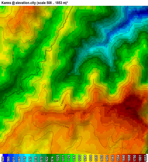
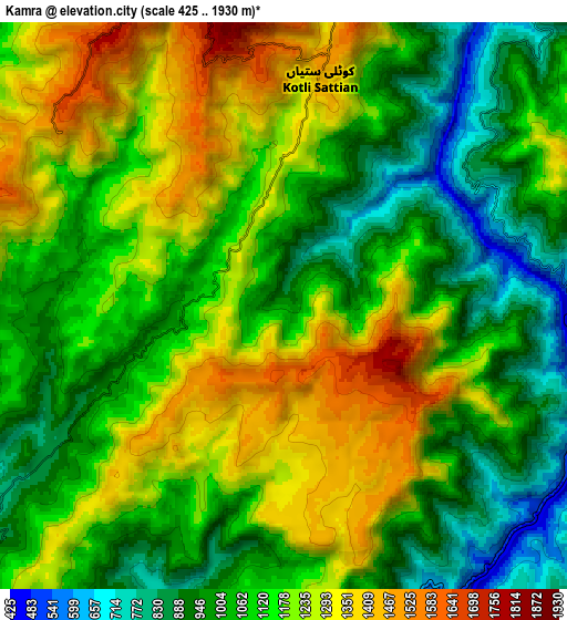
Below is the Elevation map of Kamra, which displays elevation range with different colors. Scale of the first map is from 508 to 1853 m (1667 to 6079 ft) with average elevation of 1243.9 meters (=4081 ft) [note 1]
These maps also provides idea of topography and contour of this city, they are displayed at different zoom levels. More info about maps, scale and edge coordinates you can find below images.
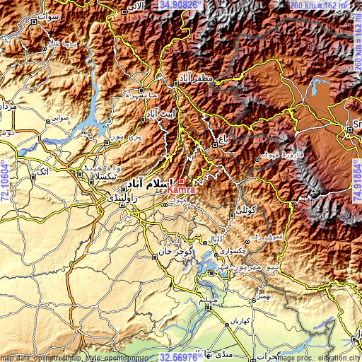
| \ | Map #1 | Map #2 | Topo.Map |
| Scale [m] | 508..1853 m | 425..1930 m | × |
| Scale [ft] | 1667..6079 ft | 1394..6332 ft | × |
| Average | 1243.9 m = 4081 ft | 1124.7 m = 3690 ft | × |
| Width | 8.13 km = 5.1 mi | 16.25 km = 10.1 mi | 260 km = 161.6 mi |
| Height | 8.13 km = 5.1 mi | 16.25 km = 10.1 mi | 260 km = 161.6 mi |
| ↑Max Latitude | 33.783513° | 33.82003° | 34.90826° |
| Latitude at center | 33.74698° | 33.74698° | 33.74698° |
| ↓Min Latitude | 33.710432° | 33.673868° | 32.56976° |
| ← Min Longitude | 73.468345° | 73.424399° | 72.10604° |
| Longitude center | 73.51229° | 73.51229° | 73.51229° |
| →Max Longitude | 73.556235° | 73.600181° | 74.91854° |
Nearby cities:
Cities around Kamra sort by population:
• Rawalpindi elevation 499 m
46.1 km,  248°
248°
• Kotli 609 m
44.1 km,  125°
125°
• Islamabad 579 m
43.5 km,  266°
266°
• Abbottabad 1241 m
52.3 km,  328°
328°
• Gujar Khan 461 m
58.1 km,  199°
199°
• Rawala Kot 1640 m
26 km,  61°
61°
• Havelian 863 m
47.1 km,  316°
316°
• Murree 2098 m
21.2 km, 327°
• Kahuta 610 m
20.8 km,  213°
213°
• Nazir Town 495 m
49.1 km,  183°
183°
• Hattian Bala 1006 m
51.5 km,  24°
24°
• Bagh 1100 m
35.6 km,  43°
43°
Multilingual:
 En español:
Kamra elevación 1006 m.
 En France:
Kamra élévation 1006 m.


Sources and notes:
- [note 1] Map square and city borders are not equal. Map elevation data is calculated only from area inside that square.
- [src 1] Elevation data from geonames database provided with same terms of usage.
- [src 2] The elevation map of Kamra is generated using elevation data from NASA's 3 arcsec (90m) resolution SRTM data.
- [src 3] Base (background) map © OpenStreetMap contributors tiles are generated by Geofabrik and OpenTopoMap.
Copyright & License:
This Kamra Elevation Map is licensed under CC BY-SA. You may reuse any part from this page, if you give a proper credit by linking to this URL:
 More info on terms of use page.