Kotli elevation
Kotli (Azad Kashmir), Pakistan elevation is 609 meters and Kotli elevation in feet is 1998 ft above sea level [src 1]. Kotli is a seat of a second-order administrative division (feature code) with elevation that is 263 meters (863 ft) bigger than average city elevation in Pakistan.
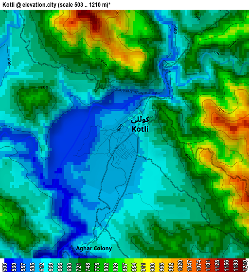
Below is the Elevation map of Kotli, which displays elevation range with different colors. Scale of the first map is from 503 to 1210 m (1650 to 3970 ft) with average elevation of 703.1 meters (=2307 ft) [note 1]
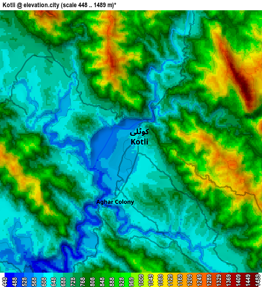
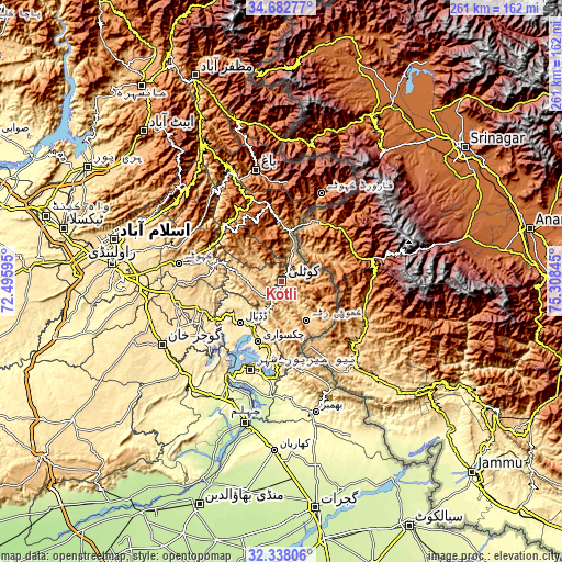
These maps also provides idea of topography and contour of this city, they are displayed at different zoom levels. More info about maps, scale and edge coordinates you can find below images.
| \ | Map #1 | Map #2 | Topo.Map |
| Scale [m] | 503..1210 m | 448..1489 m | × |
| Scale [ft] | 1650..3970 ft | 1470..4885 ft | × |
| Average | 703.1 m = 2307 ft | 783.7 m = 2571 ft | × |
| Width | 8.15 km = 5.1 mi | 16.29 km = 10.1 mi | 260.7 km = 162 mi |
| Height | 8.15 km = 5.1 mi | 16.29 km = 10.1 mi | 260.7 km = 162 mi |
| ↑Max Latitude | 33.55499° | 33.591604° | 34.68277° |
| Latitude at center | 33.51836° | 33.51836° | 33.51836° |
| ↓Min Latitude | 33.481715° | 33.445054° | 32.33806° |
| ← Min Longitude | 73.858255° | 73.814309° | 72.49595° |
| Longitude center | 73.9022° | 73.9022° | 73.9022° |
| →Max Longitude | 73.946145° | 73.990091° | 75.30845° |
Nearby cities:
Cities around Kotli sort by population:
• Bhimbar elevation 332 m
62.6 km,  164°
164°
• Jhelum 230 m
66.8 km,  193°
193°
• Gujar Khan 461 m
62.8 km,  242°
242°
• Rawala Kot 1640 m
40 km,  340°
340°
• Sarai Alamgir 232 m
69.6 km, 191°
• Kamra 1006 m
44.1 km,  305°
305°
• Murree 2098 m
64.2 km, 312°
• Kahuta 610 m
48.4 km,  279°
279°
• Nazir Town 495 m
45.5 km, 238°
• Hattian Bala 1006 m
73.8 km,  348°
348°
• Bagh 1100 m
52.8 km, 347°
• New Mirpur 436 m
43.5 km,  198°
198°
Multilingual:
 En español:
Kotli elevación 609 m.
 En France:
Kotli élévation 609 m.


Sources and notes:
- [note 1] Map square and city borders are not equal. Map elevation data is calculated only from area inside that square.
- [src 1] Elevation data from geonames database provided with same terms of usage.
- [src 2] The elevation map of Kotli is generated using elevation data from NASA's 3 arcsec (90m) resolution SRTM data.
- [src 3] Base (background) map © OpenStreetMap contributors tiles are generated by Geofabrik and OpenTopoMap.
Copyright & License:
This Kotli Elevation Map is licensed under CC BY-SA. You may reuse any part from this page, if you give a proper credit by linking to this URL:
 More info on terms of use page.