Kalabagh elevation
Kalabagh (Punjab), Pakistan elevation is 218 meters and Kalabagh elevation in feet is 715 ft above sea level [src 1]. Kalabagh is a populated place (feature code) with elevation that is 128 meters (420 ft) smaller than average city elevation in Pakistan.
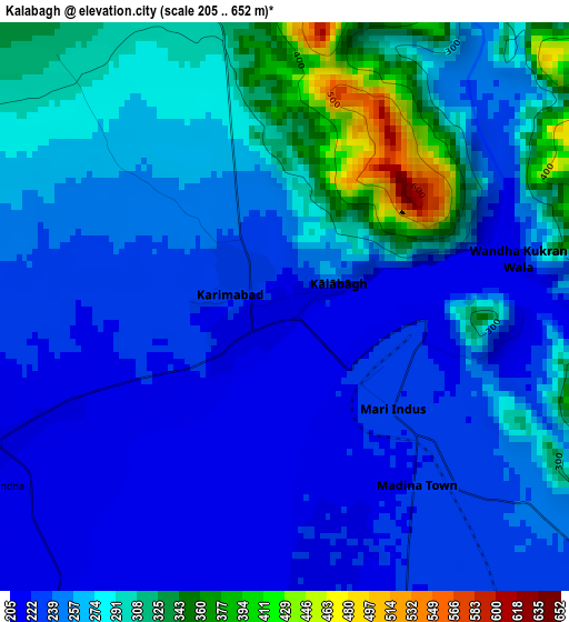
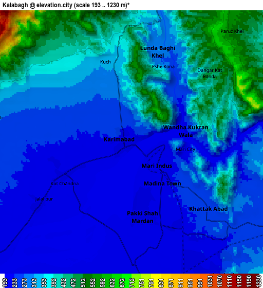
Below is the Elevation map of Kalabagh, which displays elevation range with different colors. Scale of the first map is from 205 to 652 m (673 to 2139 ft) with average elevation of 262.2 meters (=860 ft) [note 1]
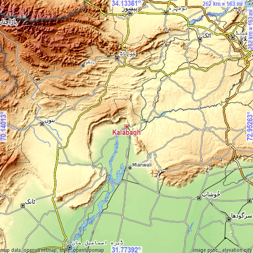
These maps also provides idea of topography and contour of this city, they are displayed at different zoom levels. More info about maps, scale and edge coordinates you can find below images.
| \ | Map #1 | Map #2 | Topo.Map |
| Scale [m] | 205..652 m | 193..1230 m | × |
| Scale [ft] | 673..2139 ft | 633..4035 ft | × |
| Average | 262.2 m = 860 ft | 318.3 m = 1044 ft | × |
| Width | 8.2 km = 5.1 mi | 16.4 km = 10.2 mi | 262.4 km = 163 mi |
| Height | 8.2 km = 5.1 mi | 16.4 km = 10.2 mi | 262.4 km = 163 mi |
| ↑Max Latitude | 32.998504° | 33.035353° | 34.13361° |
| Latitude at center | 32.96164° | 32.96164° | 32.96164° |
| ↓Min Latitude | 32.924761° | 32.887866° | 31.77392° |
| ← Min Longitude | 71.502435° | 71.458489° | 70.14013° |
| Longitude center | 71.54638° | 71.54638° | 71.54638° |
| →Max Longitude | 71.590325° | 71.634271° | 72.95263° |
Nearby cities:
Cities around Kalabagh sort by population:
• Kohat elevation 503 m
69.6 km,  352°
352°
• Mianwali 208 m
42.7 km,  182°
182°
• Lakki 267 m
71.2 km,  236°
236°
• Kundian 203 m
56.4 km,  186°
186°
• Pindi Gheb 327 m
73.8 km,  65°
65°
• Daud Khel 216 m
9.9 km,  166°
166°
• Sarai Naurang 305 m
73 km,  258°
258°
• Lachi 463 m
50.7 km,  337°
337°
• Jand 345 m
68.4 km,  39°
39°
• Kamar Mushani 213 m
21.7 km,  232°
232°
• Harnoli 194 m
75.9 km, 179°
• Karak 582 m
45.6 km,  292°
292°
Multilingual:
 En español:
Kalabagh elevación 218 m.
 En France:
Kalabagh élévation 218 m.
 Auf Deutsch:
Kalabagh höhe über dem Meeresspiegel ist 218 m.

Sources and notes:
- [note 1] Map square and city borders are not equal. Map elevation data is calculated only from area inside that square.
- [src 1] Elevation data from geonames database provided with same terms of usage.
- [src 2] The elevation map of Kalabagh is generated using elevation data from NASA's 3 arcsec (90m) resolution SRTM data.
- [src 3] Base (background) map © OpenStreetMap contributors tiles are generated by Geofabrik and OpenTopoMap.
Copyright & License:
This Kalabagh Elevation Map is licensed under CC BY-SA. You may reuse any part from this page, if you give a proper credit by linking to this URL:
 More info on terms of use page.