Pindi Gheb elevation
Pindi Gheb (Punjab), Pakistan elevation is 327 meters and Pindi Gheb elevation in feet is 1073 ft above sea level [src 1]. Pindi Gheb is a populated place (feature code) with elevation that is 19 meters (62 ft) smaller than average city elevation in Pakistan.
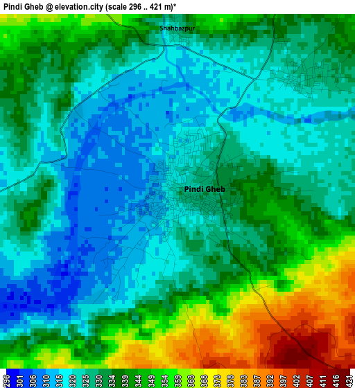
Below is the Elevation map of Pindi Gheb, which displays elevation range with different colors. Scale of the first map is from 296 to 421 m (971 to 1381 ft) with average elevation of 334 meters (=1096 ft) [note 1]
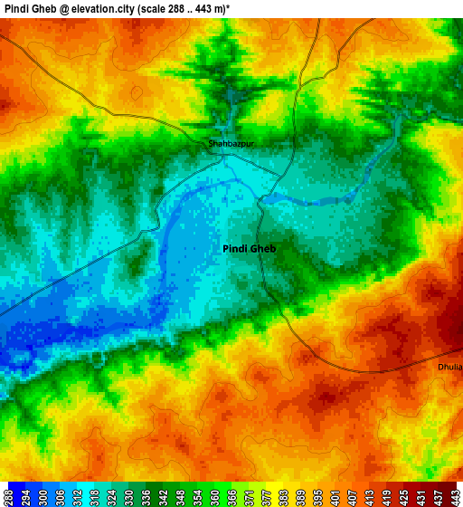
These maps also provides idea of topography and contour of this city, they are displayed at different zoom levels. More info about maps, scale and edge coordinates you can find below images.
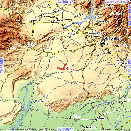
| \ | Map #1 | Map #2 | Topo.Map |
| Scale [m] | 296..421 m | 288..443 m | × |
| Scale [ft] | 971..1381 ft | 945..1453 ft | × |
| Average | 334 m = 1096 ft | 364.4 m = 1196 ft | × |
| Width | 8.17 km = 5.1 mi | 16.35 km = 10.2 mi | 261.5 km = 162.5 mi |
| Height | 8.17 km = 5.1 mi | 16.35 km = 10.2 mi | 261.5 km = 162.5 mi |
| ↑Max Latitude | 33.277697° | 33.314428° | 34.40914° |
| Latitude at center | 33.24095° | 33.24095° | 33.24095° |
| ↓Min Latitude | 33.204188° | 33.16741° | 32.05694° |
| ← Min Longitude | 72.220855° | 72.176909° | 70.85855° |
| Longitude center | 72.2648° | 72.2648° | 72.2648° |
| →Max Longitude | 72.308745° | 72.352691° | 73.67105° |
Nearby cities:
Cities around Pindi Gheb sort by population:
• Chakwal elevation 523 m
64.7 km,  121°
121°
• Attock City 355 m
59.1 km,  8°
8°
• Talagang 456 m
37.6 km,  157°
157°
• Daud Khel 216 m
76.4 km,  237°
237°
• Hazro City 320 m
77.3 km,  15°
15°
• Jand 345 m
31.3 km,  313°
313°
• Kalabagh 218 m
73.8 km,  245°
245°
• Kallar Kahar 644 m
65.3 km,  141°
141°
• Daultala 547 m
81.7 km,  93°
93°
• Sanjwal 357 m
59.9 km, 15°
• Cherat Cantonement 1336 m
73.4 km,  331°
331°
• Khandowa 779 m
70.7 km, 141°
Multilingual:
 En español:
Pindi Gheb elevación 327 m.
 En France:
Pindi Gheb élévation 327 m.
 Auf Deutsch:
Pindi Gheb höhe über dem Meeresspiegel ist 327 m.

Sources and notes:
- [note 1] Map square and city borders are not equal. Map elevation data is calculated only from area inside that square.
- [src 1] Elevation data from geonames database provided with same terms of usage.
- [src 2] The elevation map of Pindi Gheb is generated using elevation data from NASA's 3 arcsec (90m) resolution SRTM data.
- [src 3] Base (background) map © OpenStreetMap contributors tiles are generated by Geofabrik and OpenTopoMap.
Copyright & License:
This Pindi Gheb Elevation Map is licensed under CC BY-SA. You may reuse any part from this page, if you give a proper credit by linking to this URL:
 More info on terms of use page.