Jand elevation
Jand (Punjab), Pakistan elevation is 345 meters and Jand elevation in feet is 1132 ft above sea level [src 1]. Jand is a populated place (feature code) with elevation that is 1 meters (3 ft) smaller than average city elevation in Pakistan.
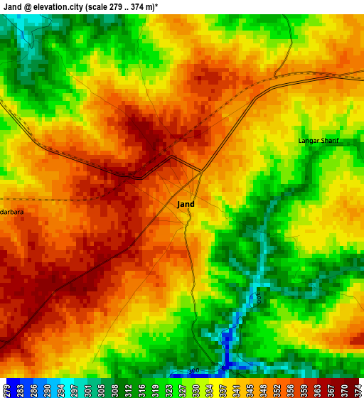
Below is the Elevation map of Jand, which displays elevation range with different colors. Scale of the first map is from 279 to 374 m (915 to 1227 ft) with average elevation of 337.4 meters (=1107 ft) [note 1]
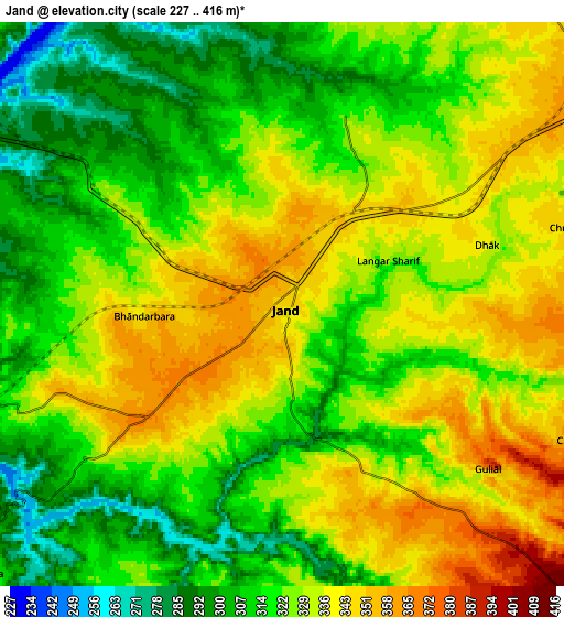
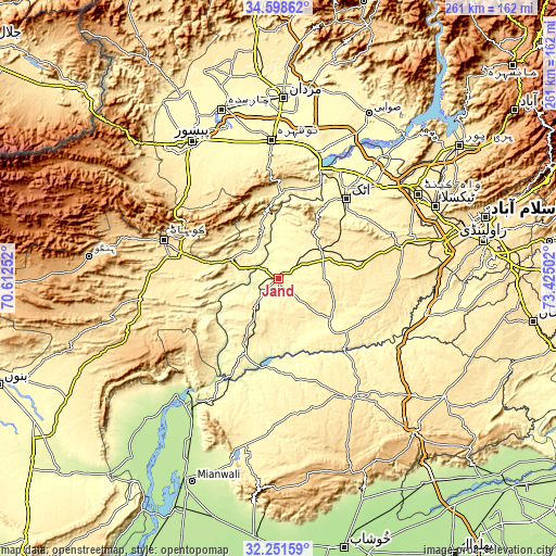
These maps also provides idea of topography and contour of this city, they are displayed at different zoom levels. More info about maps, scale and edge coordinates you can find below images.
| \ | Map #1 | Map #2 | Topo.Map |
| Scale [m] | 279..374 m | 227..416 m | × |
| Scale [ft] | 915..1227 ft | 745..1365 ft | × |
| Average | 337.4 m = 1107 ft | 324.8 m = 1066 ft | × |
| Width | 8.16 km = 5.1 mi | 16.31 km = 10.1 mi | 261 km = 162.2 mi |
| Height | 8.16 km = 5.1 mi | 16.31 km = 10.1 mi | 261 km = 162.2 mi |
| ↑Max Latitude | 33.469706° | 33.506356° | 34.59862° |
| Latitude at center | 33.43304° | 33.43304° | 33.43304° |
| ↓Min Latitude | 33.396359° | 33.359662° | 32.25159° |
| ← Min Longitude | 71.974825° | 71.930879° | 70.61252° |
| Longitude center | 72.01877° | 72.01877° | 72.01877° |
| →Max Longitude | 72.062715° | 72.106661° | 73.42502° |
Nearby cities:
Cities around Jand sort by population:
• Kohat elevation 503 m
55.3 km,  287°
287°
• Nowshera Cantonment 298 m
62.9 km,  358°
358°
• Attock City 355 m
48.7 km,  40°
40°
• Talagang 456 m
67.3 km,  146°
146°
• Pabbi 299 m
67.4 km,  342°
342°
• Pindi Gheb 327 m
31.3 km,  133°
133°
• Aman Garh 301 m
64.2 km,  352°
352°
• Akora 294 m
64.2 km,  8°
8°
• Lachi 463 m
63.5 km,  264°
264°
• Sanjwal 357 m
52.9 km,  46°
46°
• Cherat Cantonement 1336 m
44.9 km, 344°
• Nowshera 290 m
64.9 km, 356°
Multilingual:
 En español:
Jand elevación 345 m.
 En France:
Jand élévation 345 m.


Sources and notes:
- [note 1] Map square and city borders are not equal. Map elevation data is calculated only from area inside that square.
- [src 1] Elevation data from geonames database provided with same terms of usage.
- [src 2] The elevation map of Jand is generated using elevation data from NASA's 3 arcsec (90m) resolution SRTM data.
- [src 3] Base (background) map © OpenStreetMap contributors tiles are generated by Geofabrik and OpenTopoMap.
Copyright & License:
This Jand Elevation Map is licensed under CC BY-SA. You may reuse any part from this page, if you give a proper credit by linking to this URL:
 More info on terms of use page.