Sanjwal elevation
Sanjwal (Punjab), Pakistan elevation is 357 meters and Sanjwal elevation in feet is 1171 ft above sea level [src 1]. Sanjwal is a populated place (feature code) with elevation that is 11 meters (36 ft) bigger than average city elevation in Pakistan.
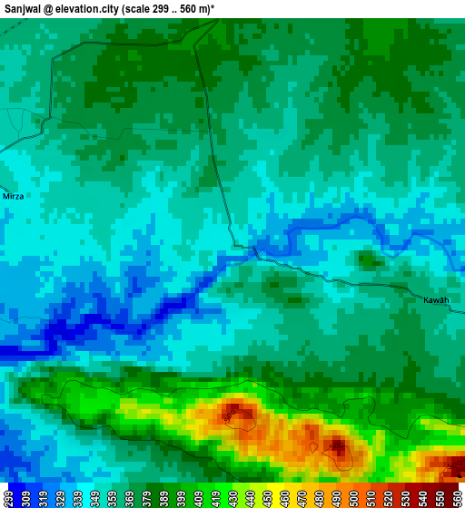
Below is the Elevation map of Sanjwal, which displays elevation range with different colors. Scale of the first map is from 299 to 560 m (981 to 1837 ft) with average elevation of 370 meters (=1214 ft) [note 1]
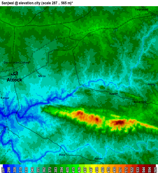
These maps also provides idea of topography and contour of this city, they are displayed at different zoom levels. More info about maps, scale and edge coordinates you can find below images.
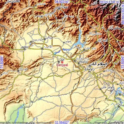
| \ | Map #1 | Map #2 | Topo.Map |
| Scale [m] | 299..560 m | 287..565 m | × |
| Scale [ft] | 981..1837 ft | 942..1854 ft | × |
| Average | 370 m = 1214 ft | 367 m = 1204 ft | × |
| Width | 8.12 km = 5 mi | 16.25 km = 10.1 mi | 260 km = 161.6 mi |
| Height | 8.12 km = 5 mi | 16.25 km = 10.1 mi | 260 km = 161.6 mi |
| ↑Max Latitude | 33.797577° | 33.834088° | 34.92214° |
| Latitude at center | 33.76105° | 33.76105° | 33.76105° |
| ↓Min Latitude | 33.724508° | 33.68795° | 32.58402° |
| ← Min Longitude | 72.389205° | 72.345259° | 71.0269° |
| Longitude center | 72.43315° | 72.43315° | 72.43315° |
| →Max Longitude | 72.477095° | 72.521041° | 73.8394° |
Nearby cities:
Cities around Sanjwal sort by population:
• Swabi elevation 341 m
40.1 km,  4°
4°
• Nowshera Cantonment 298 m
48 km,  303°
303°
• Attock City 355 m
6.8 km,  275°
275°
• Risalpur Cantonment 306 m
52.5 km,  309°
309°
• Topi 348 m
38.5 km,  26°
26°
• Zaida 320 m
33.3 km,  5°
5°
• Hazro City 320 m
17.4 km,  18°
18°
• Akora 294 m
39.1 km, 313°
• Jand 345 m
52.9 km,  226°
226°
• Cherat Cantonement 1336 m
50.4 km, 277°
• Ashanagro Koto 347 m
42.3 km,  335°
335°
• Nowshera 290 m
50.4 km, 304°
Multilingual:
 En español:
Sanjwal elevación 357 m.
 En France:
Sanjwal élévation 357 m.


Sources and notes:
- [note 1] Map square and city borders are not equal. Map elevation data is calculated only from area inside that square.
- [src 1] Elevation data from geonames database provided with same terms of usage.
- [src 2] The elevation map of Sanjwal is generated using elevation data from NASA's 3 arcsec (90m) resolution SRTM data.
- [src 3] Base (background) map © OpenStreetMap contributors tiles are generated by Geofabrik and OpenTopoMap.
Copyright & License:
This Sanjwal Elevation Map is licensed under CC BY-SA. You may reuse any part from this page, if you give a proper credit by linking to this URL:
 More info on terms of use page.