Kohat elevation
Kohat (Khyber Pakhtunkhwa), Pakistan elevation is 503 meters and Kohat elevation in feet is 1650 ft above sea level [src 1]. Kohat is a seat of a second-order administrative division (feature code) with elevation that is 157 meters (515 ft) bigger than average city elevation in Pakistan.
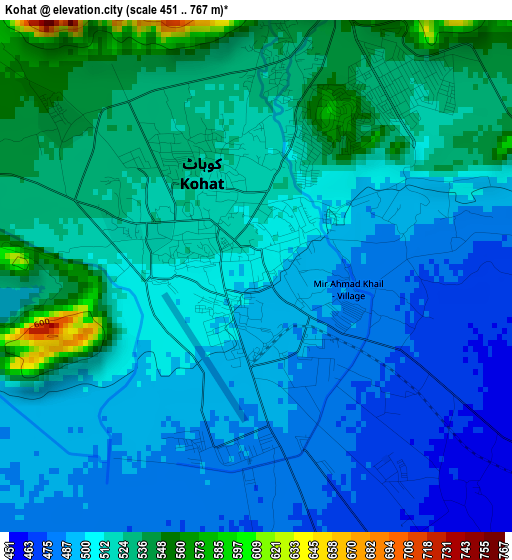
Below is the Elevation map of Kohat, which displays elevation range with different colors. Scale of the first map is from 451 to 767 m (1480 to 2516 ft) with average elevation of 510 meters (=1673 ft) [note 1]
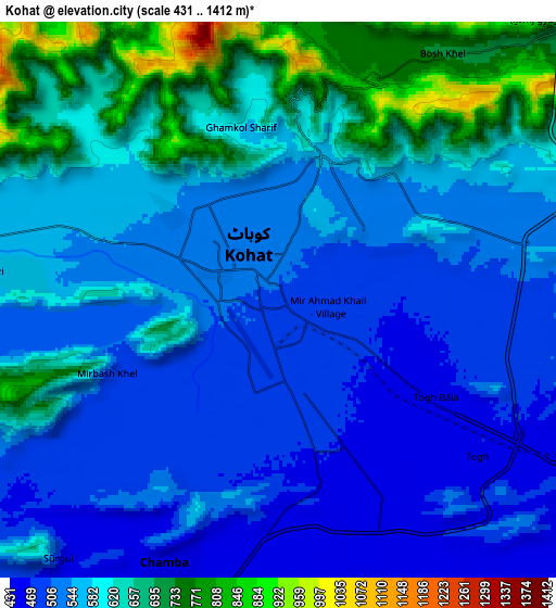
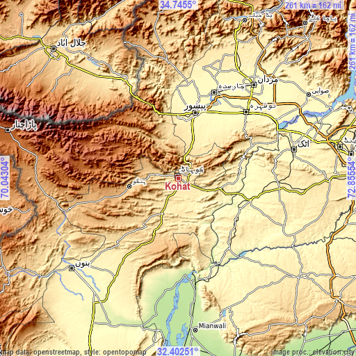
These maps also provides idea of topography and contour of this city, they are displayed at different zoom levels. More info about maps, scale and edge coordinates you can find below images.
| \ | Map #1 | Map #2 | Topo.Map |
| Scale [m] | 451..767 m | 431..1412 m | × |
| Scale [ft] | 1480..2516 ft | 1414..4633 ft | × |
| Average | 510 m = 1673 ft | 573.2 m = 1881 ft | × |
| Width | 8.14 km = 5.1 mi | 16.28 km = 10.1 mi | 260.5 km = 161.9 mi |
| Height | 8.14 km = 5.1 mi | 16.28 km = 10.1 mi | 260.5 km = 161.9 mi |
| ↑Max Latitude | 33.618563° | 33.65515° | 34.7455° |
| Latitude at center | 33.58196° | 33.58196° | 33.58196° |
| ↓Min Latitude | 33.545342° | 33.508708° | 32.40251° |
| ← Min Longitude | 71.405345° | 71.361399° | 70.04304° |
| Longitude center | 71.44929° | 71.44929° | 71.44929° |
| →Max Longitude | 71.493235° | 71.537181° | 72.85554° |
Nearby cities:
Cities around Kohat sort by population:
• Peshawar elevation 340 m
48.9 km,  14°
14°
• Nowshera Cantonment 298 m
68.7 km,  47°
47°
• Charsadda 301 m
68.5 km,  23°
23°
• Pabbi 299 m
57.3 km,  33°
33°
• Hangu 840 m
36.5 km,  261°
261°
• Aman Garh 301 m
64.7 km,  43°
43°
• Lachi 463 m
24.4 km,  205°
205°
• Jand 345 m
55.3 km,  107°
107°
• Karak 582 m
61.4 km, 212°
• Doaba 890 m
68.3 km, 255°
• Cherat Cantonement 1336 m
49 km,  56°
56°
• Landi Kotal 1064 m
64.1 km,  333°
333°
Multilingual:
 En español:
Kohat elevación 503 m.
 En France:
Kohat élévation 503 m.


Sources and notes:
- [note 1] Map square and city borders are not equal. Map elevation data is calculated only from area inside that square.
- [src 1] Elevation data from geonames database provided with same terms of usage.
- [src 2] The elevation map of Kohat is generated using elevation data from NASA's 3 arcsec (90m) resolution SRTM data.
- [src 3] Base (background) map © OpenStreetMap contributors tiles are generated by Geofabrik and OpenTopoMap.
Copyright & License:
This Kohat Elevation Map is licensed under CC BY-SA. You may reuse any part from this page, if you give a proper credit by linking to this URL:
 More info on terms of use page.