Charsadda elevation
Charsadda (Khyber Pakhtunkhwa), Pakistan elevation is 301 meters and Charsadda elevation in feet is 988 ft above sea level [src 1]. Charsadda is a seat of a second-order administrative division (feature code) with elevation that is 45 meters (148 ft) smaller than average city elevation in Pakistan.
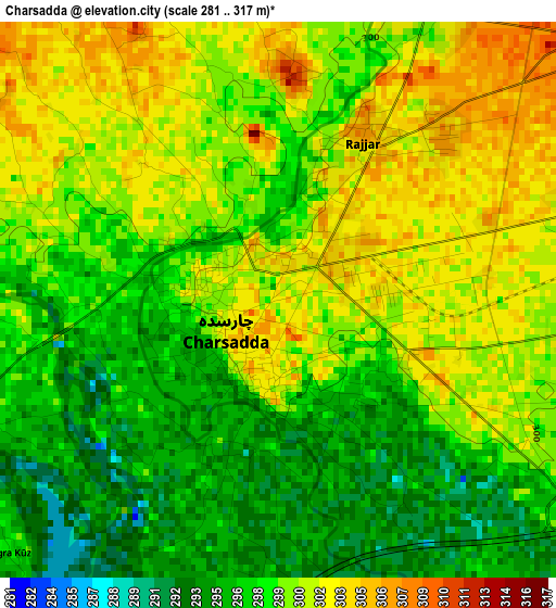
Below is the Elevation map of Charsadda, which displays elevation range with different colors. Scale of the first map is from 281 to 317 m (922 to 1040 ft) with average elevation of 299 meters (=981 ft) [note 1]
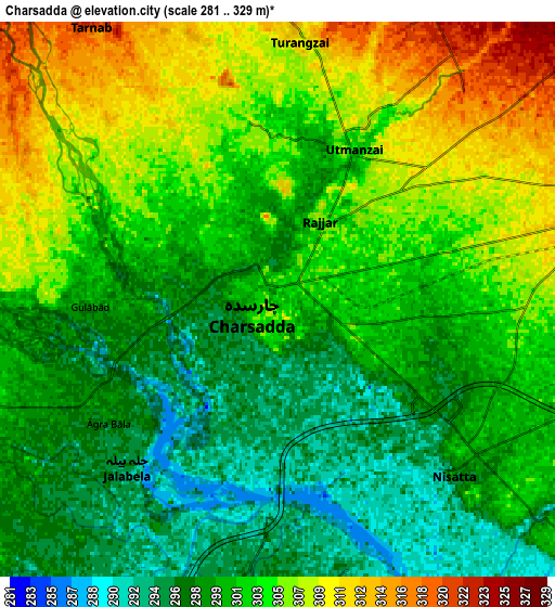
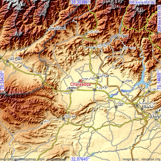
These maps also provides idea of topography and contour of this city, they are displayed at different zoom levels. More info about maps, scale and edge coordinates you can find below images.
| \ | Map #1 | Map #2 | Topo.Map |
| Scale [m] | 281..317 m | 281..329 m | × |
| Scale [ft] | 922..1040 ft | 922..1079 ft | × |
| Average | 299 m = 981 ft | 301.9 m = 990 ft | × |
| Width | 8.09 km = 5 mi | 16.18 km = 10.1 mi | 258.8 km = 160.8 mi |
| Height | 8.09 km = 5 mi | 16.18 km = 10.1 mi | 258.8 km = 160.8 mi |
| ↑Max Latitude | 34.184581° | 34.220926° | 35.30396° |
| Latitude at center | 34.14822° | 34.14822° | 34.14822° |
| ↓Min Latitude | 34.111844° | 34.075451° | 32.97645° |
| ← Min Longitude | 71.696655° | 71.652709° | 70.33435° |
| Longitude center | 71.7406° | 71.7406° | 71.7406° |
| →Max Longitude | 71.784545° | 71.828491° | 73.14685° |
Nearby cities:
Cities around Charsadda sort by population:
• Peshawar elevation 340 m
21.6 km,  223°
223°
• Mardan 311 m
29 km,  78°
78°
• Nowshera Cantonment 298 m
29 km,  125°
125°
• Shabqadar 335 m
18.7 km,  293°
293°
• Pabbi 299 m
16.2 km,  162°
162°
• Risalpur Cantonment 306 m
25.2 km,  112°
112°
• Tangi 358 m
18.8 km,  334°
334°
• Utmanzai 304 m
4.8 km,  24°
24°
• Aman Garh 301 m
23.5 km, 132°
• Cherat Cantonement 1336 m
38.7 km, 158°
• Noorabad 331 m
23.8 km,  60°
60°
• Nowshera 290 m
26.6 km,  123°
123°
Multilingual:
 En español:
Charsadda elevación 301 m.
 En France:
Charsadda élévation 301 m.
 Auf Deutsch:
Charsadda höhe über dem Meeresspiegel ist 301 m.

Sources and notes:
- [note 1] Map square and city borders are not equal. Map elevation data is calculated only from area inside that square.
- [src 1] Elevation data from geonames database provided with same terms of usage.
- [src 2] The elevation map of Charsadda is generated using elevation data from NASA's 3 arcsec (90m) resolution SRTM data.
- [src 3] Base (background) map © OpenStreetMap contributors tiles are generated by Geofabrik and OpenTopoMap.
Copyright & License:
This Charsadda Elevation Map is licensed under CC BY-SA. You may reuse any part from this page, if you give a proper credit by linking to this URL:
 More info on terms of use page.