Harnoli elevation
Harnoli (Punjab), Pakistan elevation is 194 meters and Harnoli elevation in feet is 636 ft above sea level [src 1]. Harnoli is a populated place (feature code) with elevation that is 152 meters (499 ft) smaller than average city elevation in Pakistan.
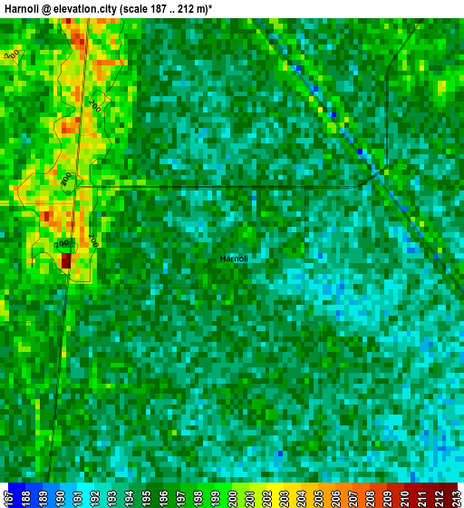
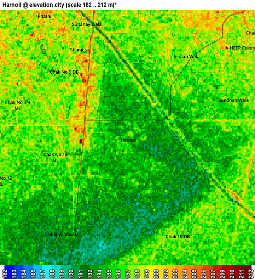
Below is the Elevation map of Harnoli, which displays elevation range with different colors. Scale of the first map is from 187 to 212 m (614 to 696 ft) with average elevation of 195 meters (=640 ft) [note 1]
These maps also provides idea of topography and contour of this city, they are displayed at different zoom levels. More info about maps, scale and edge coordinates you can find below images.
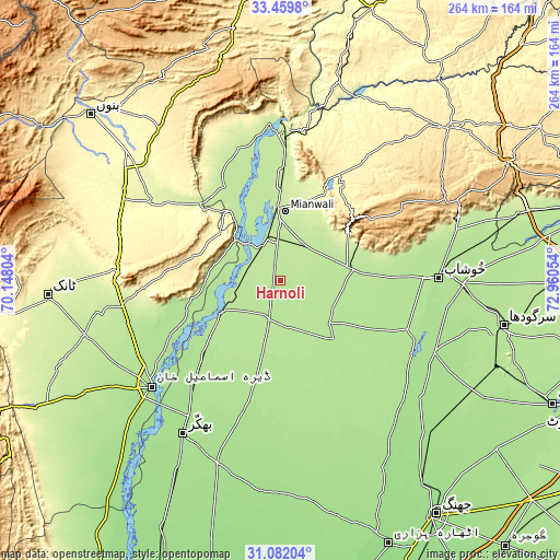
| \ | Map #1 | Map #2 | Topo.Map |
| Scale [m] | 187..212 m | 182..212 m | × |
| Scale [ft] | 614..696 ft | 597..696 ft | × |
| Average | 195 m = 640 ft | 195.9 m = 643 ft | × |
| Width | 8.26 km = 5.1 mi | 16.52 km = 10.3 mi | 264.4 km = 164.3 mi |
| Height | 8.26 km = 5.1 mi | 16.52 km = 10.3 mi | 264.4 km = 164.3 mi |
| ↑Max Latitude | 32.315856° | 32.352988° | 33.4598° |
| Latitude at center | 32.27871° | 32.27871° | 32.27871° |
| ↓Min Latitude | 32.241548° | 32.204372° | 31.08204° |
| ← Min Longitude | 71.510345° | 71.466399° | 70.14804° |
| Longitude center | 71.55429° | 71.55429° | 71.55429° |
| →Max Longitude | 71.598235° | 71.642181° | 72.96054° |
Nearby cities:
Cities around Harnoli sort by population:
• Khushāb elevation 186 m
75.1 km,  88°
88°
• Mianwali 208 m
33.3 km,  355°
355°
• Dullewala 183 m
50.6 km,  192°
192°
• Jauharabad 185 m
68.4 km, 88°
• Lakki 267 m
70.4 km,  301°
301°
• Kundian 203 m
21.1 km,  340°
340°
• Daud Khel 216 m
66.4 km,  1°
1°
• Mitha Tiwana 190 m
52 km, 94°
• Kalur Kot 191 m
30.4 km,  243°
243°
• Paharpur 182 m
58.2 km,  250°
250°
• Kamar Mushani 213 m
65.3 km, 343°
• Darya Khan 176 m
69.6 km,  217°
217°
Multilingual:
 En español:
Harnoli elevación 194 m.
 En France:
Harnoli élévation 194 m.


Sources and notes:
- [note 1] Map square and city borders are not equal. Map elevation data is calculated only from area inside that square.
- [src 1] Elevation data from geonames database provided with same terms of usage.
- [src 2] The elevation map of Harnoli is generated using elevation data from NASA's 3 arcsec (90m) resolution SRTM data.
- [src 3] Base (background) map © OpenStreetMap contributors tiles are generated by Geofabrik and OpenTopoMap.
Copyright & License:
This Harnoli Elevation Map is licensed under CC BY-SA. You may reuse any part from this page, if you give a proper credit by linking to this URL:
 More info on terms of use page.