Surab elevation
Surab (Balochistan), Pakistan elevation is 1762 meters and Surab elevation in feet is 5781 ft above sea level [src 1]. Surab is a populated place (feature code) with elevation that is 1416 meters (4646 ft) bigger than average city elevation in Pakistan.
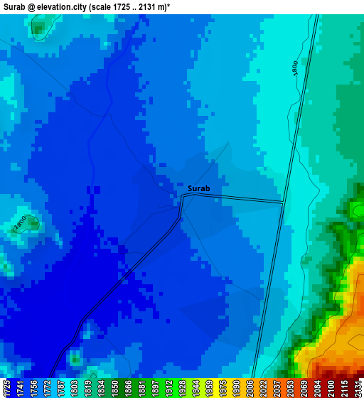
Below is the Elevation map of Surab, which displays elevation range with different colors. Scale of the first map is from 1725 to 2131 m (5659 to 6991 ft) with average elevation of 1780.5 meters (=5842 ft) [note 1]
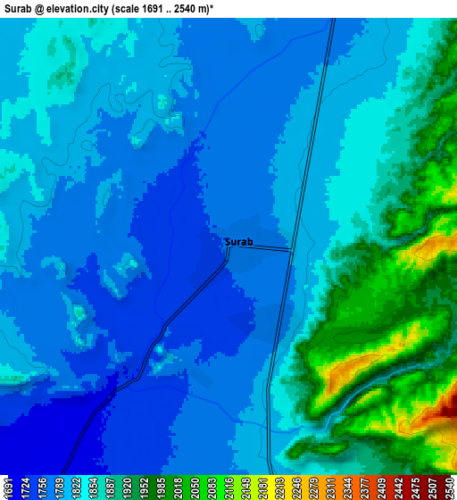
These maps also provides idea of topography and contour of this city, they are displayed at different zoom levels. More info about maps, scale and edge coordinates you can find below images.
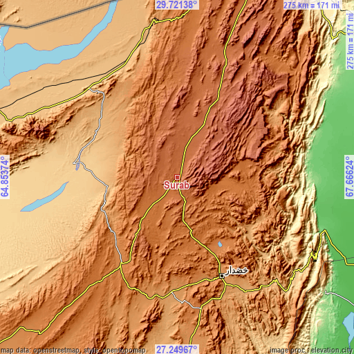
| \ | Map #1 | Map #2 | Topo.Map |
| Scale [m] | 1725..2131 m | 1691..2540 m | × |
| Scale [ft] | 5659..6991 ft | 5548..8333 ft | × |
| Average | 1780.5 m = 5842 ft | 1835.7 m = 6023 ft | × |
| Width | 8.59 km = 5.3 mi | 17.18 km = 10.7 mi | 274.8 km = 170.8 mi |
| Height | 8.59 km = 5.3 mi | 17.18 km = 10.7 mi | 274.8 km = 170.8 mi |
| ↑Max Latitude | 28.531375° | 28.569977° | 29.72138° |
| Latitude at center | 28.49276° | 28.49276° | 28.49276° |
| ↓Min Latitude | 28.45413° | 28.415487° | 27.24967° |
| ← Min Longitude | 66.216045° | 66.172099° | 64.85374° |
| Longitude center | 66.25999° | 66.25999° | 66.25999° |
| →Max Longitude | 66.303935° | 66.347881° | 67.66624° |
Nearby cities:
Cities around Surab sort by population:
• Khuzdar elevation 1233 m
83.2 km,  155°
155°
• Shahdad Kot 52 m
176.7 km,  113°
113°
• Usta Muhammad 57 m
178.1 km,  101°
101°
• Kharan 722 m
83.2 km,  277°
277°
• Mastung 1682 m
156 km,  21°
21°
• Nushki 997 m
120 km,  348°
348°
• Kalat 2014 m
67.7 km,  28°
28°
• Dadhar 160 m
173.9 km,  51°
51°
• Bhag 103 m
164.2 km,  68°
68°
• Garhi Khairo 51 m
175.2 km, 105°
• Chowki Jamali 48 m
171 km, 107°
• Gandava 88 m
120.5 km,  83°
83°
Multilingual:
 En español:
Surab elevación 1762 m.
 En France:
Surab élévation 1762 m.


Sources and notes:
- [note 1] Map square and city borders are not equal. Map elevation data is calculated only from area inside that square.
- [src 1] Elevation data from geonames database provided with same terms of usage.
- [src 2] The elevation map of Surab is generated using elevation data from NASA's 3 arcsec (90m) resolution SRTM data.
- [src 3] Base (background) map © OpenStreetMap contributors tiles are generated by Geofabrik and OpenTopoMap.
Copyright & License:
This Surab Elevation Map is licensed under CC BY-SA. You may reuse any part from this page, if you give a proper credit by linking to this URL:
 More info on terms of use page.