Gandava elevation
Gandava (Balochistan), Pakistan elevation is 88 meters and Gandava elevation in feet is 289 ft above sea level [src 1]. Gandava is a seat of a second-order administrative division (feature code) with elevation that is 258 meters (846 ft) smaller than average city elevation in Pakistan.
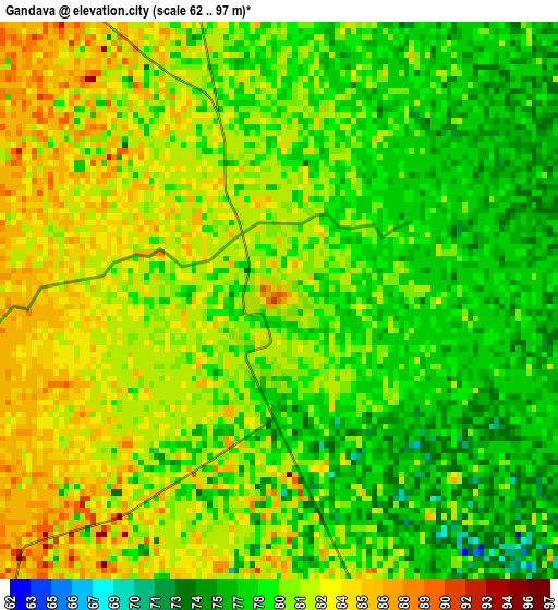
Below is the Elevation map of Gandava, which displays elevation range with different colors. Scale of the first map is from 62 to 97 m (203 to 318 ft) with average elevation of 80.1 meters (=263 ft) [note 1]
These maps also provides idea of topography and contour of this city, they are displayed at different zoom levels. More info about maps, scale and edge coordinates you can find below images.
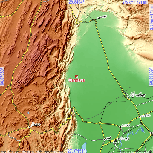
| \ | Map #1 | Topo.Map |
| Scale [m] | 62..97 m | × |
| Scale [ft] | 203..318 ft | × |
| Average | 80.1 m = 263 ft | × |
| Width | 8.58 km = 5.3 mi | 274.5 km = 170.6 mi |
| Height | 8.58 km = 5.3 mi | 274.5 km = 170.6 mi |
| ↑Max Latitude | 28.651781° | 29.8404° |
| Latitude at center | 28.61321° | 28.61321° |
| ↓Min Latitude | 28.574625° | 27.37151° |
| ← Min Longitude | 67.441695° | 66.07939° |
| Longitude center | 67.48564° | 67.48564° |
| →Max Longitude | 67.529585° | 68.89189° |
Nearby cities:
Cities around Gandava sort by population:
• Jacobabad elevation 60 m
100.1 km,  111°
111°
• Shahdad Kot 52 m
94.6 km,  154°
154°
• Usta Muhammad 57 m
73 km,  131°
131°
• Mehrabpur 53 m
77.1 km,  136°
136°
• Kalat 2014 m
98.3 km,  297°
297°
• Dadhar 160 m
97.2 km,  9°
9°
• Bhag 103 m
57.9 km,  34°
34°
• Garhi Khairo 51 m
78.3 km, 141°
• Sohbatpur 59 m
103.8 km,  95°
95°
• Chowki Jamali 48 m
78.6 km, 147°
• Dera Allahyar 58 m
88.6 km, 107°
• Dera Murad Jamali 68 m
72.4 km, 95°
Multilingual:
 En español:
Gandava elevación 88 m.
 En France:
Gandava élévation 88 m.


Sources and notes:
- [note 1] Map square and city borders are not equal. Map elevation data is calculated only from area inside that square.
- [src 1] Elevation data from geonames database provided with same terms of usage.
- [src 2] The elevation map of Gandava is generated using elevation data from NASA's 3 arcsec (90m) resolution SRTM data.
- [src 3] Base (background) map © OpenStreetMap contributors tiles are generated by Geofabrik and OpenTopoMap.
Copyright & License:
This Gandava Elevation Map is licensed under CC BY-SA. You may reuse any part from this page, if you give a proper credit by linking to this URL:
 More info on terms of use page.