Jacobabad elevation
Jacobabad (Sindh, Jacobabad District), Pakistan elevation is 60 meters and Jacobabad elevation in feet is 197 ft above sea level [src 1]. Jacobabad is a seat of a second-order administrative division (feature code) with elevation that is 286 meters (938 ft) smaller than average city elevation in Pakistan.
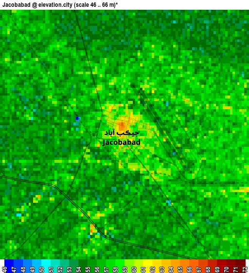
Below is the Elevation map of Jacobabad, which displays elevation range with different colors. Scale of the first map is from 46 to 66 m (151 to 217 ft) with average elevation of 55.9 meters (=183 ft) [note 1]
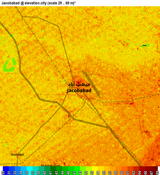
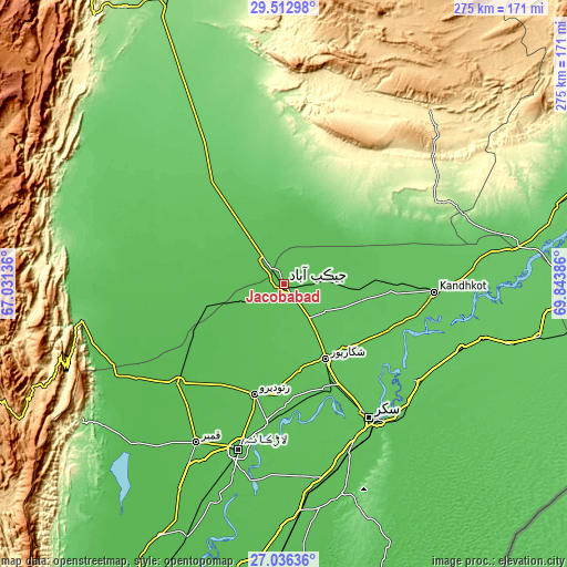
These maps also provides idea of topography and contour of this city, they are displayed at different zoom levels. More info about maps, scale and edge coordinates you can find below images.
| \ | Map #1 | Map #2 | Topo.Map |
| Scale [m] | 46..66 m | 29..69 m | × |
| Scale [ft] | 151..217 ft | 95..226 ft | × |
| Average | 55.9 m = 183 ft | 55.9 m = 183 ft | × |
| Width | 8.61 km = 5.3 mi | 17.21 km = 10.7 mi | 275.4 km = 171.1 mi |
| Height | 8.61 km = 5.3 mi | 17.21 km = 10.7 mi | 275.4 km = 171.1 mi |
| ↑Max Latitude | 28.320562° | 28.359241° | 29.51298° |
| Latitude at center | 28.28187° | 28.28187° | 28.28187° |
| ↓Min Latitude | 28.243164° | 28.204443° | 27.03636° |
| ← Min Longitude | 68.393665° | 68.349719° | 67.03136° |
| Longitude center | 68.43761° | 68.43761° | 68.43761° |
| →Max Longitude | 68.481555° | 68.525501° | 69.84386° |
Nearby cities:
Cities around Jacobabad sort by population:
• Shikarpur elevation 71 m
41.3 km,  151°
151°
• Usta Muhammad 57 m
40.3 km,  253°
253°
• Mehrabpur 53 m
44.8 km,  244°
244°
• Thul 64 m
33.4 km,  97°
97°
• Garhiyasin 60 m
42.4 km,  170°
170°
• Garhi Khairo 51 m
51.1 km, 241°
• Lakhi 72 m
54.6 km, 151°
• Tangwani 68 m
54.8 km,  90°
90°
• Rustam 70 m
50.2 km,  134°
134°
• Sohbatpur 59 m
28.5 km,  21°
21°
• Dera Murad Jamali 68 m
36.1 km,  324°
324°
• Dera Allahyar 58 m
13.3 km, 320°
Multilingual:
 En español:
Jacobabad elevación 60 m.
 En France:
Jacobabad élévation 60 m.
 Auf Deutsch:
Jacobabad höhe über dem Meeresspiegel ist 60 m.

Sources and notes:
- [note 1] Map square and city borders are not equal. Map elevation data is calculated only from area inside that square.
- [src 1] Elevation data from geonames database provided with same terms of usage.
- [src 2] The elevation map of Jacobabad is generated using elevation data from NASA's 3 arcsec (90m) resolution SRTM data.
- [src 3] Base (background) map © OpenStreetMap contributors tiles are generated by Geofabrik and OpenTopoMap.
Copyright & License:
This Jacobabad Elevation Map is licensed under CC BY-SA. You may reuse any part from this page, if you give a proper credit by linking to this URL:
 More info on terms of use page.