Nushki elevation
Nushki (Balochistan), Pakistan elevation is 997 meters and Nushki elevation in feet is 3271 ft above sea level [src 1]. Nushki is a populated place (feature code) with elevation that is 651 meters (2136 ft) bigger than average city elevation in Pakistan.
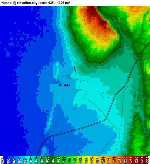
Below is the Elevation map of Nushki, which displays elevation range with different colors. Scale of the first map is from 935 to 1326 m (3068 to 4350 ft) with average elevation of 1012.2 meters (=3321 ft) [note 1]
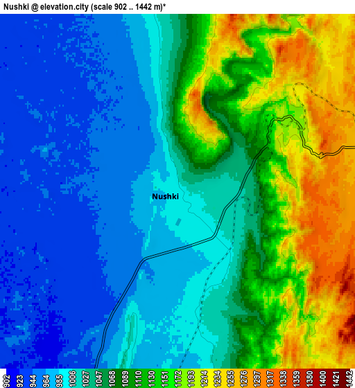
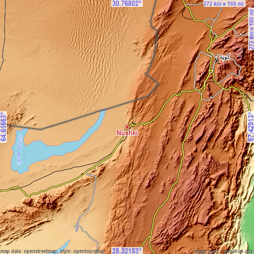
These maps also provides idea of topography and contour of this city, they are displayed at different zoom levels. More info about maps, scale and edge coordinates you can find below images.
| \ | Map #1 | Map #2 | Topo.Map |
| Scale [m] | 935..1326 m | 902..1442 m | × |
| Scale [ft] | 3068..4350 ft | 2959..4731 ft | × |
| Average | 1012.2 m = 3321 ft | 1058.4 m = 3472 ft | × |
| Width | 8.5 km = 5.3 mi | 17 km = 10.6 mi | 272 km = 169 mi |
| Height | 8.5 km = 5.3 mi | 17 km = 10.6 mi | 272 km = 169 mi |
| ↑Max Latitude | 29.590401° | 29.628608° | 30.76802° |
| Latitude at center | 29.55218° | 29.55218° | 29.55218° |
| ↓Min Latitude | 29.513944° | 29.475694° | 28.32153° |
| ← Min Longitude | 65.978935° | 65.934989° | 64.61663° |
| Longitude center | 66.02288° | 66.02288° | 66.02288° |
| →Max Longitude | 66.066825° | 66.110771° | 67.42913° |
Nearby cities:
Cities around Nushki sort by population:
• Quetta elevation 1683 m
117.6 km,  53°
53°
• Chaman 1336 m
157.3 km,  15°
15°
• Kot Malik Barkhurdar 1651 m
117.9 km, 52°
• Kharan 722 m
122.7 km,  208°
208°
• Mastung 1682 m
84.1 km,  70°
70°
• Kalat 2014 m
80.5 km,  136°
136°
• Pishin 1541 m
147.8 km,  39°
39°
• Mach 977 m
130.9 km, 74°
• Dadhar 160 m
157.8 km,  93°
93°
• Dalbandin 851 m
173.4 km,  244°
244°
• Surab 1762 m
120 km,  168°
168°
• Qila Abdullah 1562 m
144.4 km,  25°
25°
Multilingual:
 En español:
Nushki elevación 997 m.
 En France:
Nushki élévation 997 m.


Sources and notes:
- [note 1] Map square and city borders are not equal. Map elevation data is calculated only from area inside that square.
- [src 1] Elevation data from geonames database provided with same terms of usage.
- [src 2] The elevation map of Nushki is generated using elevation data from NASA's 3 arcsec (90m) resolution SRTM data.
- [src 3] Base (background) map © OpenStreetMap contributors tiles are generated by Geofabrik and OpenTopoMap.
Copyright & License:
This Nushki Elevation Map is licensed under CC BY-SA. You may reuse any part from this page, if you give a proper credit by linking to this URL:
 More info on terms of use page.